Saint-Angeau (Saint-Angeau)

- former commune in Charente, France
- Country:

- Postal Code: 16230
- Coordinates: 45° 50' 54" N, 0° 17' 12" E


- GPS tracks (wikiloc): [Link]
- Area: 10.94 sq km
- Population: 768
- Wikipedia en: wiki(en)
- Wikipedia: wiki(fr)
- Wikidata storage: Wikidata: Q918117
- Wikipedia Commons Category: [Link]
- Freebase ID: [/m/03mcd4d]
- GeoNames ID: Alt: [2981701]
- SIREN number: [211603006]
- BnF ID: [15248739x]
- PACTOLS thesaurus ID: [pcrtMgXyyNSwcj]
- INSEE municipality code: 16300
Shares border with regions:

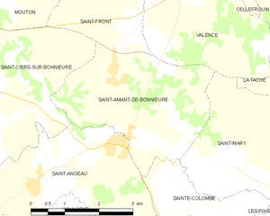
Saint-Amant-de-Bonnieure
- former commune in Charente, France
- Country:
- Postal Code: 16230
- Coordinates: 45° 51' 8" N, 0° 17' 37" E
- GPS tracks (wikiloc): [Link]
- Area: 10.67 sq km
- Population: 358


Coulgens
- commune in Charente, France
- Country:
- Postal Code: 16560
- Coordinates: 45° 48' 41" N, 0° 17' 13" E
- GPS tracks (wikiloc): [Link]
- Area: 11.7 sq km
- Population: 540
- Web site: [Link]


La Rochette
- commune in Charente, France
- Country:
- Postal Code: 16110
- Coordinates: 45° 48' 5" N, 0° 18' 50" E
- GPS tracks (wikiloc): [Link]
- Area: 10.99 sq km
- Population: 530
- Web site: [Link]


Aussac-Vadalle
- commune in Charente, France
- Country:
- Postal Code: 16560
- Coordinates: 45° 48' 59" N, 0° 13' 14" E
- GPS tracks (wikiloc): [Link]
- AboveSeaLevel: 109 м m
- Area: 17.61 sq km
- Population: 517
- Web site: [Link]


Saint-Ciers-sur-Bonnieure
- commune in Charente, France
- Country:
- Postal Code: 16230
- Coordinates: 45° 51' 35" N, 0° 14' 40" E
- GPS tracks (wikiloc): [Link]
- Area: 10.44 sq km
- Population: 328
- Web site: [Link]


Nanclars
- commune in Charente, France
- Country:
- Postal Code: 16230
- Coordinates: 45° 50' 40" N, 0° 13' 11" E
- GPS tracks (wikiloc): [Link]
- Area: 5.73 sq km
- Population: 196


Sainte-Colombe
- former commune in Charente, France
- Country:
- Postal Code: 16230
- Coordinates: 45° 50' 0" N, 0° 19' 8" E
- GPS tracks (wikiloc): [Link]
- AboveSeaLevel: 78 м m
- Area: 6.5 sq km
- Population: 188