Saint-Bon-Tarentaise (Saint-Bon-Tarentaise)

- former commune in Savoie, France
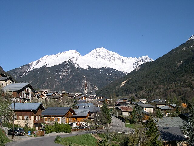
 Hiking in Saint-Bon-Tarentaise
Saint-Bon-Tarentaise is a stunning region located in the French Alps, known for its breathtaking mountain scenery and a variety of outdoor activities, especially hiking. Here are some key points about hiking in this beautiful area:
1.
- The region is characterized by dramatic alpine landscapes, including majestic peaks, lush valleys, and crystal-clear lakes.
- It is part of the Vanoise National Park, which is home to diverse flora and fauna, making it a great destination for nature lovers.
2.
- There is a wide range of hiking trails suitable for various skill levels, from easy walks to challenging treks.
- Popular trails often lead to stunning viewpoints, such as the Grande Casse and other iconic peaks in the Mont Blanc Massif.
3.
- The best time to hike in Saint-Bon-Tarentaise is typically from late spring to early autumn (May to October). During these months, the weather is milder, and the trails are more accessible.
- Be aware that higher-altitude trails may still have snow in early summer, so check trail conditions if you plan to hike in late spring.
4.
- The area has various visitor centers and local guides who can provide maps and information about the trails, as well as guided hiking options if desired.
- Many hotels and lodges in the region also offer hiking packages or organize excursions.
5.
- Always inform someone about your hiking plans, especially if you are heading into remote areas.
- Carry enough water, snacks, and a map or GPS. Cell service can be limited in the mountains.
- Dress in layers, as weather conditions can change rapidly in the mountains.
6.
- Keep an eye out for local wildlife, including marmots, chamois, and maybe even a golden eagle.
- Enjoy the peacefulness of the surroundings, and take time to soak in the beauty of the views.
7.
- The region is rich in cultural history, with charming alpine villages and traditional architecture. Consider incorporating visits to local markets or cultural sites along your hike.
In summary, hiking in Saint-Bon-Tarentaise presents a fantastic opportunity to explore the natural beauty of the French Alps, catering to both novice hikers and experienced trail enthusiasts. Whether you’re looking for a casual walk or a challenging adventure, there are plenty of trails to satisfy your outdoor cravings.
- Country:

- Postal Code: 73120
- Coordinates: 45° 26' 2" N, 6° 38' 13" E


- GPS tracks (wikiloc): [Link]
- Area: 58.94 sq km
- Population: 1901
- Web site: http://www.mairie-courchevel.com
- Wikipedia en: wiki(en)
- Wikipedia: wiki(fr)
- Wikidata storage: Wikidata: Q735334
- Wikipedia Commons Category: [Link]
- Freebase ID: [/m/03npfhb]
- GeoNames ID: Alt: [6442864]
- BnF ID: [152741586]
- VIAF ID: Alt: [153787951]
- INSEE municipality code: 73227
Shares border with regions:
Montagny
- commune in Savoie, France
Hiking in Montagny
Montagny, located in the Savoie region of the French Alps, is an excellent destination for hiking enthusiasts. Nestled amid stunning mountainous scenery, it offers a variety of trails suitable for different skill levels, ranging from leisurely walks to challenging hikes. Here are some highlights about hiking in the area:...
- Country:
- Postal Code: 73350
- Coordinates: 45° 27' 22" N, 6° 35' 31" E
- GPS tracks (wikiloc): [Link]
- Area: 13.26 sq km
- Population: 662

Bozel
- commune in Savoie, France
Hiking in Bozel
Bozel is a charming village located in the Savoie region of the French Alps, close to the renowned ski resorts of Courchevel and Les 3 Vallées. While it's popular for winter sports, Bozel also offers fantastic hiking opportunities in the warmer months, attracting outdoor enthusiasts to explore its beautiful landscapes....
- Country:
- Postal Code: 73350
- Coordinates: 45° 26' 34" N, 6° 38' 56" E
- GPS tracks (wikiloc): [Link]
- Area: 28.8 sq km
- Population: 1959
- Web site: [Link]


Les Allues
- commune in Savoie, France
Hiking in Les Allues
Les Allues is a charming village located in the French Alps, near the popular ski resort of Méribel in the Tarentaise Valley. While it is best known for its winter sports, Les Allues also offers beautiful hiking opportunities during the warmer months....
- Country:
- Postal Code: 73550
- Coordinates: 45° 25' 51" N, 6° 33' 23" E
- GPS tracks (wikiloc): [Link]
- Area: 85.99 sq km
- Population: 1848


Planay, Savoie
- commune in Savoie, France
Hiking in Planay, Savoie
Planay, located in the Savoie region of the French Alps, is a beautiful destination for hiking enthusiasts. The area is known for its stunning alpine landscapes, picturesque villages, and various hiking trails suitable for different experience levels. Here’s what you can expect when hiking in Planay:...
- Country:
- Postal Code: 73350
- Coordinates: 45° 25' 23" N, 6° 41' 55" E
- GPS tracks (wikiloc): [Link]
- Area: 22.41 sq km
- Population: 412


Pralognan-la-Vanoise
- commune in Savoie, France
Hiking in Pralognan-la-Vanoise
Pralognan-la-Vanoise is a charming village located in the heart of the Vanoise National Park in the French Alps. It is an excellent destination for hiking enthusiasts, offering a diverse range of trails suitable for varying skill levels, as well as breathtaking scenery....
- Country:
- Postal Code: 73710
- Coordinates: 45° 22' 53" N, 6° 43' 17" E
- GPS tracks (wikiloc): [Link]
- Area: 88.57 sq km
- Population: 744
- Web site: [Link]


La Perrière
- former commune in Savoie, France
Hiking in La Perrière
La Perrière, located in the Savoie region of the French Alps, offers some stunning hiking opportunities that appeal to a variety of skill levels. The region is characterized by its breathtaking mountain landscapes, alpine meadows, and rich biodiversity, making it a fantastic destination for outdoor enthusiasts....
- Country:
- Postal Code: 73600
- Coordinates: 45° 26' 42" N, 6° 35' 38" E
- GPS tracks (wikiloc): [Link]
- Area: 9.96 sq km
- Population: 469