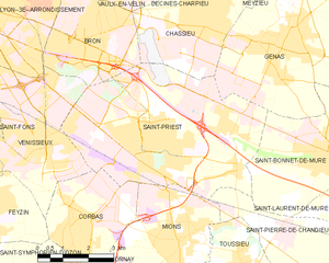
Saint-Bonnet-de-Mure (Saint-Bonnet-de-Mure)
- commune in Rhône, France
 Hiking in Saint-Bonnet-de-Mure
Saint-Bonnet-de-Mure is a charming commune located near Lyon, in the Auvergne-Rhône-Alpes region of France. While it may not be as famous as some larger hiking destinations, it offers some pleasant trails and outdoor opportunities for hikers. Here are a few points of interest regarding hiking in and around Saint-Bonnet-de-Mure:
Local Trails
-
Nearby Parks and Natural Areas: Explore local parks such as the Parc de la Mure. While not extensive, these parks can offer short trails suitable for casual walks and family hikes.
-
Surrounding Areas: There are many hiking opportunities in the nearby Pilat Regional Natural Park, which features more substantial trails with varied difficulty levels. You can find beautiful landscapes, including hills, forests, and views of the Rhône Valley.
-
Lyon to Saint-Bonnet Pathways: If you are looking for a longer hike, consider the pathways that connect Saint-Bonnet-de-Mure to Lyon, which may include sections along rivers or through agricultural land.
Hiking Tips
- Preparation: Always check the weather before heading out and dress in layers. Bring enough water and snacks for your hike.
- Maps and Navigation: It’s helpful to have a map or a GPS app, especially if you venture into less marked areas.
- Local Guides or Groups: Check for local hiking clubs or guides that may offer organized hikes or tours, providing insight into the area’s flora and fauna.
Other Activities
In addition to hiking, you can consider cycling or walking in the scenic countryside. Nearby towns and cultural sites can also enhance your hike with historical explorations.
Overall, while Saint-Bonnet-de-Mure itself might not be a major hiking hub, its proximity to Lyon and natural parks provides opportunities for enjoyable outdoor experiences.
- Country:

- Postal Code: 69720
- Coordinates: 45° 41' 26" N, 5° 1' 45" E


- GPS tracks (wikiloc): [Link]
- Area: 16.34 sq km
- Population: 6851
- Web site: http://www.saintbonnetdemure.com
- Wikipedia en: wiki(en)
- Wikipedia: wiki(fr)
- Wikidata storage: Wikidata: Q1650056
- Wikipedia Commons Category: [Link]
- Freebase ID: [/m/03qgf97]
- Freebase ID: [/m/03qgf97]
- GeoNames ID: Alt: [6441832]
- GeoNames ID: Alt: [6441832]
- SIREN number: [216902874]
- SIREN number: [216902874]
- BnF ID: [152723735]
- BnF ID: [152723735]
- GND ID: Alt: [4625648-9]
- GND ID: Alt: [4625648-9]
- INSEE municipality code: 69287
- INSEE municipality code: 69287
Shares border with regions:


Saint-Laurent-de-Mure
- commune in Rhône, France
 Hiking in Saint-Laurent-de-Mure
Saint-Laurent-de-Mure is a charming commune located in the Auvergne-Rhône-Alpes region of France, near Lyon. While it may not be as famous as some of the larger national parks, it offers some scenic opportunities for hiking and enjoying the natural landscape....
- Country:

- Postal Code: 69720
- Coordinates: 45° 41' 8" N, 5° 2' 41" E


- GPS tracks (wikiloc): [Link]
- Area: 18.63 sq km
- Population: 5391
- Web site: [Link]


Saint-Priest
- commune in the metropolis of Lyon, France
- Country:

- Postal Code: 69800
- Coordinates: 45° 41' 47" N, 4° 56' 38" E


- GPS tracks (wikiloc): [Link]
- AboveSeaLevel: 208 м m
- Area: 29.71 sq km
- Population: 45097
- Web site: [Link]


Colombier-Saugnieu
- commune in Rhône, France
Colombier-Saugnieu, located in the Auvergne-Rhône-Alps region of France, offers a variety of hiking opportunities that showcase the natural beauty of the surrounding landscape. Here are some key points about hiking in this area:...
- Country:

- Postal Code: 69124
- Coordinates: 45° 42' 41" N, 5° 6' 44" E


- GPS tracks (wikiloc): [Link]
- Area: 27.62 sq km
- Population: 2554


Genas
- commune in Rhône, France
- Country:

- Postal Code: 69740
- Coordinates: 45° 43' 53" N, 5° 0' 8" E


- GPS tracks (wikiloc): [Link]
- Area: 23.84 sq km
- Population: 12741
- Web site: [Link]


Saint-Pierre-de-Chandieu
- commune in Rhône, France
 Hiking in Saint-Pierre-de-Chandieu
Saint-Pierre-de-Chandieu is a small commune located in the Rhône department of the Auvergne-Rhône-Alpes region in France, not far from the city of Lyon. While it may not be as widely recognized as a hiking destination compared to larger national parks or mountainous areas, it offers some charming trails and outdoor activities....
- Country:

- Postal Code: 69780
- Coordinates: 45° 38' 47" N, 5° 0' 53" E


- GPS tracks (wikiloc): [Link]
- Area: 29.28 sq km
- Population: 4546
- Web site: [Link]
