Saint-Chamant (Saint-Chamant)

- commune in Cantal, France
- Country:

- Postal Code: 15140
- Coordinates: 45° 5' 27" N, 2° 26' 21" E


- GPS tracks (wikiloc): [Link]
- Area: 13.72 sq km
- Population: 234
- Wikipedia en: wiki(en)
- Wikipedia: wiki(fr)
- Wikidata storage: Wikidata: Q734549
- Wikipedia Commons Category: [Link]
- Freebase ID: [/m/03mb9rl]
- GeoNames ID: Alt: [6427626]
- SIREN number: [211501762]
- BnF ID: [152483463]
- INSEE municipality code: 15176
Shares border with regions:

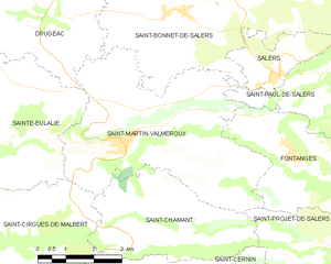
Saint-Martin-Valmeroux
- commune in Cantal, France
- Country:
- Postal Code: 15140
- Coordinates: 45° 7' 3" N, 2° 25' 30" E
- GPS tracks (wikiloc): [Link]
- Area: 25.92 sq km
- Population: 793

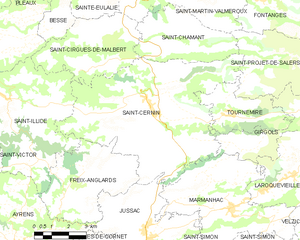
Saint-Cernin
- commune in Cantal, France
- Country:
- Postal Code: 15310
- Coordinates: 45° 3' 31" N, 2° 25' 15" E
- GPS tracks (wikiloc): [Link]
- Area: 46.75 sq km
- Population: 1087
- Web site: [Link]
Saint-Cirgues-de-Malbert
- commune in Cantal, France
- Country:
- Postal Code: 15140
- Coordinates: 45° 5' 54" N, 2° 23' 36" E
- GPS tracks (wikiloc): [Link]
- Area: 16.21 sq km
- Population: 249


Saint-Projet-de-Salers
- commune in Cantal, France
- Country:
- Postal Code: 15140
- Coordinates: 45° 5' 8" N, 2° 31' 36" E
- GPS tracks (wikiloc): [Link]
- Area: 36.32 sq km
- Population: 138