Saint-Chaffrey (Saint-Chaffrey)
- commune in Hautes-Alpes, France
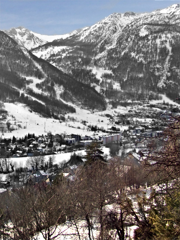
 Hiking in Saint-Chaffrey
Saint-Chaffrey is a charming commune located in the Hautes-Alpes region of France, and it's part of the broader area known for its stunning alpine scenery and outdoor activities, particularly hiking. Here are some key points about hiking in and around Saint-Chaffrey:
Scenic Trails
- Varied Terrain: The area offers a range of hiking trails that cater to different skill levels, from easy walks suitable for families to challenging hikes for more experienced adventurers.
- Breathtaking Views: Many trails provide stunning panoramic views of the surrounding mountains, including the Écrins National Park, which is known for its dramatic landscapes.
Popular Hiking Routes
- The Vallée de la Clarée: This valley is renowned for its beautiful scenery and offers a number of hiking paths that allow you to explore the flora and fauna of the region.
- Col du Granon: A popular trail leading to a mountain pass where hikers can enjoy spectacular views of the surrounding peaks. This route can be more challenging and is suitable for experienced hikers.
Accessibility
- Starting Points: Saint-Chaffrey serves as a great base for accessing numerous hiking trails. The village is well-connected and offers access to various starting points for hikes in the vicinity.
- Local Guides: Consider hiring a local guide if you're unfamiliar with the area. They can provide valuable insights into the best trails, safety tips, and information about the local environment.
Best Time to Hike
- Summer Months: The best time for hiking in Saint-Chaffrey is generally from late spring to early autumn (June to September) when the weather is milder and the trails are more accessible.
- Winter Hiking: For those interested in winter sports, there are also opportunities for snowshoeing and winter hikes, but it's important to check local conditions and consider safety gear.
Preparation
- Equipment: Ensure you're equipped with proper hiking boots, clothing suitable for changing weather conditions, water, snacks, and a map or GPS device.
- Safety: Always inform someone about your hiking plans and be aware of your physical limitations. It's also advisable to check the weather forecast before heading out.
Conclusion
Hiking in Saint-Chaffrey offers a fantastic opportunity to immerse yourself in the natural beauty of the French Alps. Whether you're looking for a leisurely stroll or a challenging trek, the area provides a variety of options to suit all preferences. Enjoy your hiking adventures!
- Country:

- Postal Code: 05330
- Coordinates: 44° 55' 34" N, 6° 36' 24" E


- GPS tracks (wikiloc): [Link]
- Area: 25.88 sq km
- Population: 1643
- Web site: http://www.saint-chaffrey.fr
- Wikipedia en: wiki(en)
- Wikipedia: wiki(fr)
- Wikidata storage: Wikidata: Q1085935
- Wikipedia Commons Category: [Link]
- Freebase ID: [/m/03mfp84]
- Freebase ID: [/m/03mfp84]
- GeoNames ID: Alt: [6425627]
- GeoNames ID: Alt: [6425627]
- SIREN number: [210501334]
- SIREN number: [210501334]
- PACTOLS thesaurus ID: [pcrtw3qFFyVfIu]
- PACTOLS thesaurus ID: [pcrtw3qFFyVfIu]
- INSEE municipality code: 05133
- INSEE municipality code: 05133
Shares border with regions:

Val-des-Prés
- commune in Hautes-Alpes, France
Hiking in Val-des-Prés
Val-des-Prés is a picturesque commune located in the Alpes-de-Haute-Provence region of France, known for its stunning landscapes and outdoor recreational opportunities, particularly hiking. Here are some key points to consider if you're planning to hike in Val-des-Prés:...
- Country:
- Postal Code: 05100
- Coordinates: 44° 56' 54" N, 6° 40' 42" E
- GPS tracks (wikiloc): [Link]
- Area: 44.77 sq km
- Population: 656
- Web site: [Link]

Puy-Saint-André
- commune in Hautes-Alpes, France
Hiking in Puy-Saint-André
Puy-Saint-André is a charming village located in the Hautes-Alpes region of southeastern France, and it serves as a wonderful base for hiking enthusiasts. Nestled near the Écrins National Park, the area boasts stunning alpine scenery, diverse flora and fauna, and a range of trails suitable for various skill levels....
- Country:
- Postal Code: 05100
- Coordinates: 44° 52' 44" N, 6° 35' 55" E
- GPS tracks (wikiloc): [Link]
- Area: 15.37 sq km
- Population: 466

Puy-Saint-Pierre
- commune in Hautes-Alpes, France
Hiking in Puy-Saint-Pierre
Puy-Saint-Pierre is a charming commune located in the Hautes-Alpes region of southeastern France. It's surrounded by stunning landscapes and offers a range of hiking opportunities, perfect for both beginner and experienced hikers. Here are some highlights about hiking in Puy-Saint-Pierre:...
- Country:
- Postal Code: 05100
- Coordinates: 44° 53' 27" N, 6° 37' 26" E
- GPS tracks (wikiloc): [Link]
- Area: 7.74 sq km
- Population: 529

Briançon
- commune in Hautes-Alpes, France
Hiking in Briançon
Briançon, located in the French Alps, is renowned for its stunning natural beauty and rich history. It sits at an elevation of about 1,326 meters (4,347 feet) and is surrounded by impressive mountain ranges, making it an ideal destination for hiking enthusiasts....
- Country:
- Postal Code: 05100
- Coordinates: 44° 53' 45" N, 6° 38' 6" E
- GPS tracks (wikiloc): [Link]
- AboveSeaLevel: 1325 м m
- Area: 28.07 sq km
- Population: 12370
- Web site: [Link]
La Salle-les-Alpes
- commune in Hautes-Alpes, France
Hiking in La Salle-les-Alpes
La Salle-les-Alpes, located in the Hautes-Alpes region of southeastern France, is a fantastic destination for hiking enthusiasts. Nestled in the enchanting Écrins National Park, this charming village offers breathtaking mountain views, diverse landscapes, and a variety of trails suited for all skill levels....
- Country:
- Postal Code: 05240
- Coordinates: 44° 56' 41" N, 6° 34' 15" E
- GPS tracks (wikiloc): [Link]
- AboveSeaLevel: 1397 м m
- Area: 35.42 sq km
- Population: 1003