La Salle-les-Alpes (La Salle-les-Alpes)
- commune in Hautes-Alpes, France
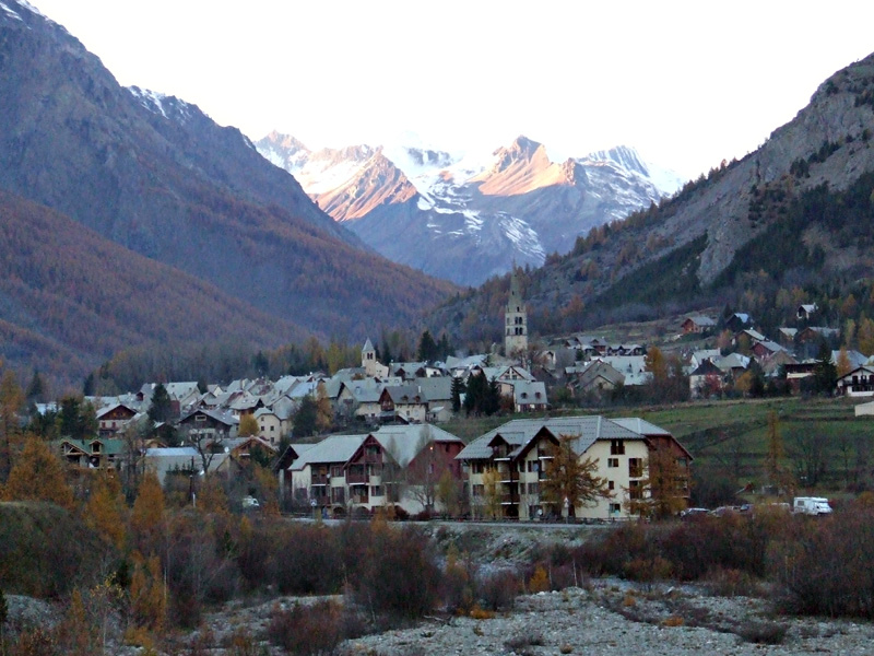
 Hiking in La Salle-les-Alpes
La Salle-les-Alpes, located in the Hautes-Alpes region of southeastern France, is a fantastic destination for hiking enthusiasts. Nestled in the enchanting Écrins National Park, this charming village offers breathtaking mountain views, diverse landscapes, and a variety of trails suited for all skill levels.
Key Features of Hiking in La Salle-les-Alpes:
-
Scenic Trails:
- The area boasts numerous well-marked hiking trails that lead you through stunning alpine landscapes, including meadows, forests, and rocky terrain.
- Popular trails include those leading to the Col du Granon and the Jardin des Neiges, offering panoramic views of the surrounding peaks.
-
Variety of Difficulty Levels:
- There are hikes suitable for beginners and families, as well as more challenging routes for experienced hikers. You can find short, leisurely walks or strenuous multi-day hikes.
-
Wildlife and Flora:
- The diverse ecosystems in and around the Écrins National Park are home to many species of flora and fauna. Keep an eye out for wildflowers, marmots, and possibly ibex as you hike.
-
Access to Alpine Lakes:
- Some trails lead to beautiful alpine lakes, such as Lac de la Douche, providing perfect spots for a picnic or just resting while enjoying the view.
-
Seasonal Considerations:
- Summer is ideal for hiking, with warmer temperatures and longer daylight hours, but be mindful of potential thunderstorms in the afternoons.
- Early autumn (September-October) can also be beautiful as the foliage changes colors. Snow can limit hiking options in late autumn and winter, but some trails can still be accessed with appropriate gear.
-
Local Guides and Resources:
- Consider hiring a local guide for tailored experiences or for exploring off-the-beaten-path trails. The local tourist office can provide maps, information on trail conditions, and guided hike options.
-
Safety Tips:
- Always check the weather forecast before heading out and be prepared for changes in weather.
- Ensure you have proper footwear, attire, and sufficient water and snacks.
- Let someone know your itinerary and expected return time.
Overall, hiking in La Salle-les-Alpes promises a memorable outdoor experience with the opportunity to appreciate the stunning beauty of the Alps. Whether you're looking for a leisurely day hike or an adventurous trek through the mountains, this location has something to offer everyone.
- Country:

- Postal Code: 05240
- Coordinates: 44° 56' 41" N, 6° 34' 15" E


- GPS tracks (wikiloc): [Link]
- AboveSeaLevel: 1397 м m
- Area: 35.42 sq km
- Population: 1003
- Wikipedia en: wiki(en)
- Wikipedia: wiki(fr)
- Wikidata storage: Wikidata: Q582511
- Wikipedia Commons Category: [Link]
- Freebase ID: [/m/03mfnsb]
- Freebase ID: [/m/03mfnsb]
- GeoNames ID: Alt: [3006541]
- GeoNames ID: Alt: [3006541]
- SIREN number: [210501615]
- SIREN number: [210501615]
- PACTOLS thesaurus ID: [pcrtMOSvNJKn6z]
- PACTOLS thesaurus ID: [pcrtMOSvNJKn6z]
- INSEE municipality code: 05161
- INSEE municipality code: 05161
Shares border with regions:
Le Monêtier-les-Bains
- commune in Hautes-Alpes, France
Hiking in Le Monêtier-les-Bains
Le Monêtier-les-Bains, located in the Hautes-Alpes region of France, is a stunning destination for hiking enthusiasts. Nestled in the Serre Chevalier Valley, this alpine village offers a variety of trails that cater to all levels of hikers, from beginners to experienced adventurers. Here are some highlights and tips for hiking in Le Monêtier-les-Bains:...
- Country:
- Postal Code: 05220
- Coordinates: 44° 58' 34" N, 6° 30' 31" E
- GPS tracks (wikiloc): [Link]
- Area: 97.87 sq km
- Population: 1024
- Web site: [Link]

Val-des-Prés
- commune in Hautes-Alpes, France
Hiking in Val-des-Prés
Val-des-Prés is a picturesque commune located in the Alpes-de-Haute-Provence region of France, known for its stunning landscapes and outdoor recreational opportunities, particularly hiking. Here are some key points to consider if you're planning to hike in Val-des-Prés:...
- Country:
- Postal Code: 05100
- Coordinates: 44° 56' 54" N, 6° 40' 42" E
- GPS tracks (wikiloc): [Link]
- Area: 44.77 sq km
- Population: 656
- Web site: [Link]

Saint-Chaffrey
- commune in Hautes-Alpes, France
Hiking in Saint-Chaffrey
Saint-Chaffrey is a charming commune located in the Hautes-Alpes region of France, and it's part of the broader area known for its stunning alpine scenery and outdoor activities, particularly hiking. Here are some key points about hiking in and around Saint-Chaffrey:...
- Country:
- Postal Code: 05330
- Coordinates: 44° 55' 34" N, 6° 36' 24" E
- GPS tracks (wikiloc): [Link]
- Area: 25.88 sq km
- Population: 1643
- Web site: [Link]

Puy-Saint-André
- commune in Hautes-Alpes, France
Hiking in Puy-Saint-André
Puy-Saint-André is a charming village located in the Hautes-Alpes region of southeastern France, and it serves as a wonderful base for hiking enthusiasts. Nestled near the Écrins National Park, the area boasts stunning alpine scenery, diverse flora and fauna, and a range of trails suitable for various skill levels....
- Country:
- Postal Code: 05100
- Coordinates: 44° 52' 44" N, 6° 35' 55" E
- GPS tracks (wikiloc): [Link]
- Area: 15.37 sq km
- Population: 466

Pelvoux
- former commune in Hautes-Alpes, France
Hiking in Pelvoux
Pelvoux is a beautiful region located in the French Alps, specifically in the Ecrins National Park. It's known for its stunning mountain landscapes, varied hiking trails, and breathtaking views. Here are some key points to keep in mind when planning a hiking trip to Pelvoux:...
- Country:
- Postal Code: 05340
- Coordinates: 44° 52' 9" N, 6° 29' 12" E
- GPS tracks (wikiloc): [Link]
- Area: 76.23 sq km
- Population: 483

Névache
- commune in Hautes-Alpes, France
Hiking in Névache
Névache, located in the Hautes-Alpes region of France, is a beautiful destination for hiking enthusiasts. Nestled in the Écrins National Park, Névache is known for its stunning landscapes, including alpine meadows, rugged mountains, and crystal-clear rivers. Here are some highlights and tips for hiking in the area:...
- Country:
- Postal Code: 05100
- Coordinates: 45° 1' 7" N, 6° 36' 17" E
- GPS tracks (wikiloc): [Link]
- Area: 191.93 sq km
- Population: 359
- Web site: [Link]