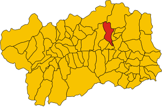
Saint-Denis, Aosta Valley (Saint-Denis)
.svg)
- Italian comune
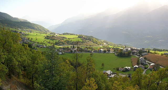
 Hiking in Saint-Denis, Aosta Valley
Saint-Denis in the Aosta Valley is a beautiful location for hiking, surrounded by stunning alpine landscapes and offering a variety of trails suited for different skill levels. Here are some key points about hiking in this region:
Landscape and Nature
- Scenic Views: The Aosta Valley is known for its mountainous terrain, rich flora and diverse fauna. As you hike, you can enjoy views of the surrounding peaks, lush valleys, and picturesque villages.
- Wildlife: Keep an eye out for local wildlife, including chamois, ibex, and a variety of bird species.
Hiking Trails
- Difficulty Levels: Trails range from easy walks suitable for families to more challenging ascents for experienced hikers. Whether you’re looking for a leisurely stroll or an intensive hike, there's something for everyone.
- Trail Markings: There are well-marked trails throughout the area, making navigation easier. Make sure to carry a map or a GPS device.
Popular Trails
- Trails around Mont Avic Natural Park: A must-visit for scenic hiking and diverse ecosystems.
- The Via Alta della Val d’Aosta: This long-distance trail offers connection through several stages, showcasing the region's natural beauty.
Best Times to Hike
- Summer (June to September): This is the best time for hiking, as the weather is generally mild and the trails are in good condition. However, early summer hikes may still have some snow at higher altitudes.
- Fall: Autumn offers spectacular foliage but be mindful of colder temperatures and shorter daylight hours.
Preparation and Safety
- Gear: Wear proper hiking boots and bring layers of clothing. The weather can change rapidly in the mountains, so it’s essential to be prepared.
- Hydration and Nutrition: Carry enough water and snacks, as you may not find facilities on some trails.
- Check Local Guides: It can be beneficial to consult local hiking organizations or guides for the latest trail conditions or recommendations.
Accessibility
- Transportation: Saint-Denis is well-connected by public transport to other towns in the valley, making it easy to access trailheads.
Overall, hiking in Saint-Denis offers a fantastic opportunity to experience the natural beauty of the Aosta Valley. Whether you’re a seasoned hiker or just starting, you will find a trail that suits your preferences. Always remember to respect nature and follow local guidelines to ensure a safe and enjoyable experience.
- Country:

- Postal Code: 11023
- Local Dialing Code: 0166
- Licence Plate Code: AO
- Coordinates: 45° 45' 0" N, 7° 33' 0" E


- GPS tracks (wikiloc): [Link]
- AboveSeaLevel: 820 м m
- Area: 11.39 sq km
- Population: 369
- Web site: http://www.comune.saintdenis.ao.it/
- Wikipedia en: wiki(en)
- Wikipedia: wiki(it)
- Wikidata storage: Wikidata: Q35352
- Wikipedia Commons Category: [Link]
- Wikipedia Commons Maps Category: [Link]
- Freebase ID: [/m/0fwz86]
- GeoNames ID: Alt: [6535989]
- OSM relation ID: [45975]
- Quora topic ID: [Saint-Denis]
- ISTAT ID: 007059
- Italian cadastre code: H670
Shares border with regions:


Antey-Saint-André
- Italian comune
Hiking in Antey-Saint-André
Antey-Saint-André is a charming commune located in the Aosta Valley region of Italy, surrounded by stunning Alpine scenery, making it a great destination for hiking enthusiasts. Here are some key points to consider for hiking in this area:...
- Country:
- Postal Code: 11020
- Local Dialing Code: 0166
- Licence Plate Code: AO
- Coordinates: 45° 48' 0" N, 7° 36' 0" E
- GPS tracks (wikiloc): [Link]
- AboveSeaLevel: 1074 м m
- Area: 11.81 sq km
- Population: 573
- Web site: [Link]


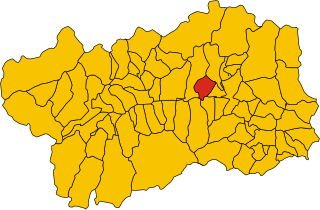
Chambave
- Italian comune
Hiking in Chambave
Chambave, located in the Aosta Valley of Italy, offers scenic hiking opportunities amidst stunning Alpine landscapes. This charming village is surrounded by picturesque mountains, vineyards, and historical sites, making it a great base for outdoor enthusiasts....
- Country:
- Postal Code: 11023
- Local Dialing Code: 0166
- Licence Plate Code: AO
- Coordinates: 45° 45' 0" N, 7° 33' 0" E
- GPS tracks (wikiloc): [Link]
- AboveSeaLevel: 480 м m
- Area: 21.54 sq km
- Population: 937
- Web site: [Link]


Châtillon
- Italian comune
Hiking in Châtillon
Châtillon is a charming town located in the Aosta Valley region of Italy, surrounded by stunning mountainous landscapes that make it a great starting point for hiking enthusiasts. Here’s what you should know about hiking in and around Châtillon:...
- Country:
- Postal Code: 11024
- Local Dialing Code: 0166
- Licence Plate Code: AO
- Coordinates: 45° 45' 0" N, 7° 37' 0" E
- GPS tracks (wikiloc): [Link]
- AboveSeaLevel: 549 м m
- Area: 39.68 sq km
- Population: 4654
- Web site: [Link]


Pontey
- Italian comune
Hiking in Pontey
Pontey is a small village located in the Aosta Valley region of Italy, surrounded by picturesque landscapes and beautiful mountain scenery. It offers several hiking opportunities that are suitable for a range of skill levels, from beginner to more experienced hikers. Here are some key points about hiking in Pontey:...
- Country:
- Postal Code: 11024
- Local Dialing Code: 0166
- Licence Plate Code: AO
- Coordinates: 45° 44' 0" N, 7° 35' 0" E
- GPS tracks (wikiloc): [Link]
- AboveSeaLevel: 523 м m
- Area: 15.75 sq km
- Population: 815
- Web site: [Link]

Torgnon
- Italian comune
Hiking in Torgnon
Torgnon is a beautiful village located in the Aosta Valley region of Italy, nestled in the Italian Alps. It's known for its stunning landscapes, lush valleys, and pristine nature, making it an ideal destination for hiking enthusiasts. Here are some key points about hiking in Torgnon:...
- Country:
- Postal Code: 11020
- Local Dialing Code: 0166
- Licence Plate Code: AO
- Coordinates: 45° 48' 0" N, 7° 34' 0" E
- GPS tracks (wikiloc): [Link]
- AboveSeaLevel: 1489 м m
- Area: 42.46 sq km
- Population: 587
- Web site: [Link]
Verrayes
- Italian comune
Hiking in Verrayes
Verrayes is a beautiful municipality located in the Aosta Valley region of Italy. It's known for its stunning landscapes, charming villages, and the surrounding mountains, which offer a variety of hiking opportunities suitable for different skill levels. Here are some key points about hiking in Verrayes:...
- Country:
- Postal Code: 11020
- Local Dialing Code: 0166
- Licence Plate Code: AO
- Coordinates: 45° 46' 0" N, 7° 32' 0" E
- GPS tracks (wikiloc): [Link]
- AboveSeaLevel: 1017 м m
- Area: 22.36 sq km
- Population: 1303
- Web site: [Link]