Torgnon (Torgnon)
- Italian comune
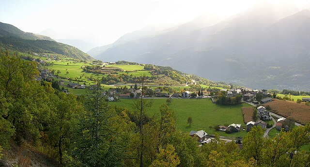
Torgnon is a beautiful village located in the Aosta Valley region of Italy, nestled in the Italian Alps. It's known for its stunning landscapes, lush valleys, and pristine nature, making it an ideal destination for hiking enthusiasts. Here are some key points about hiking in Torgnon:
Hiking Trails
-
Diverse Difficulty Levels: Torgnon offers a range of trails suitable for all skill levels, from beginner to advanced. Whether you're looking for a leisurely stroll or a challenging hike, there are options for everyone.
-
Nature and Scenery: Hikes in Torgnon typically feature breathtaking views of the surrounding mountain ranges, valleys, and even the Matterhorn on clear days. The lush forests, alpine meadows, and clear streams enhance the natural beauty of the area.
-
Signposted Trails: Many trails are well-marked and maintained, making it easy for hikers to navigate the routes. Information boards are often present to provide details about the trails, local flora, and fauna.
Popular Hiking Routes
-
Col Fenêtre: This hike leads you to a mountain pass that provides panoramic views of the Aosta Valley and surrounding peaks. It's a moderate trek that rewards hikers with stunning vistas.
-
Lago di Nana: A picturesque hike that takes you to a serene alpine lake. This trail is great for a day trip and is suitable for families.
-
Giro del Mont Velan: This is a more challenging hike that offers beautiful scenery and a chance to experience the high alpine environment.
Tips for Hiking in Torgnon
-
Check the Weather: The weather in the mountains can change rapidly, so it’s important to check forecasts before heading out and be prepared for various conditions.
-
Proper Gear: Wear appropriate hiking boots and clothing. Layering is key due to temperature fluctuations. Don't forget a hat, sunscreen, and sufficient water.
-
Respect Nature: Follow the principles of Leave No Trace. Stay on marked paths, take your trash with you, and avoid disturbing wildlife.
-
Local Recommendations: Consider visiting local tourist information centers for updated maps and advice on trails, as well as insights on seasonal events or guided hikes.
-
Safety First: Always let someone know your hiking plans, especially if you're venturing off the beaten path.
Hiking in Torgnon offers a fantastic opportunity to immerse yourself in nature, enjoy fresh mountain air, and experience the serenity of the Italian Alps. Whether you're looking for an adventurous day hike or a peaceful nature walk, Torgnon provides the perfect backdrop.
- Country:

- Postal Code: 11020
- Local Dialing Code: 0166
- Licence Plate Code: AO
- Coordinates: 45° 48' 0" N, 7° 34' 0" E


- GPS tracks (wikiloc): [Link]
- AboveSeaLevel: 1489 м m
- Area: 42.46 sq km
- Population: 587
- Web site: http://www.comune.torgnon.ao.it
- Wikipedia en: wiki(en)
- Wikipedia: wiki(it)
- Wikidata storage: Wikidata: Q35504
- Wikipedia Commons Category: [Link]
- Wikipedia Commons Maps Category: [Link]
- Freebase ID: [/m/0ft07t]
- GeoNames ID: Alt: [6536390]
- BnF ID: [131636607]
- VIAF ID: Alt: [136210107]
- OSM relation ID: [46123]
- ISTAT ID: 007067
- Italian cadastre code: L217
Shares border with regions:


Antey-Saint-André
- Italian comune
Antey-Saint-André is a charming commune located in the Aosta Valley region of Italy, surrounded by stunning Alpine scenery, making it a great destination for hiking enthusiasts. Here are some key points to consider for hiking in this area:...
- Country:

- Postal Code: 11020
- Local Dialing Code: 0166
- Licence Plate Code: AO
- Coordinates: 45° 48' 0" N, 7° 36' 0" E


- GPS tracks (wikiloc): [Link]
- AboveSeaLevel: 1074 м m
- Area: 11.81 sq km
- Population: 573
- Web site: [Link]


Bionaz
- Italian comune
Bionaz is a picturesque valley located in the Aosta Valley region of Italy, offering stunning landscapes, charming scenery, and a variety of hiking opportunities. Here’s what you need to know about hiking in Bionaz:...
- Country:

- Postal Code: 11010
- Local Dialing Code: 0165
- Licence Plate Code: AO
- Coordinates: 45° 52' 0" N, 7° 25' 0" E


- GPS tracks (wikiloc): [Link]
- AboveSeaLevel: 1606 м m
- Area: 142.09 sq km
- Population: 235
- Web site: [Link]


Châtillon
- Italian comune
Châtillon is a charming town located in the Aosta Valley region of Italy, surrounded by stunning mountainous landscapes that make it a great starting point for hiking enthusiasts. Here’s what you should know about hiking in and around Châtillon:...
- Country:

- Postal Code: 11024
- Local Dialing Code: 0166
- Licence Plate Code: AO
- Coordinates: 45° 45' 0" N, 7° 37' 0" E


- GPS tracks (wikiloc): [Link]
- AboveSeaLevel: 549 м m
- Area: 39.68 sq km
- Population: 4654
- Web site: [Link]


Nus
- Italian comune
Nus, a charming village located in the Aosta Valley region of Italy, offers some wonderful hiking opportunities. The picturesque landscape is characterized by mountains, valleys, and lush greenery, making it a great destination for outdoor enthusiasts. Here are some key points about hiking in Nus:...
- Country:

- Postal Code: 11020
- Local Dialing Code: 0165
- Licence Plate Code: AO
- Coordinates: 45° 44' 0" N, 7° 28' 0" E


- GPS tracks (wikiloc): [Link]
- AboveSeaLevel: 529 м m
- Area: 57.36 sq km
- Population: 2991
- Web site: [Link]
Saint-Denis, Aosta Valley
- Italian comune
 Hiking in Saint-Denis, Aosta Valley
Saint-Denis in the Aosta Valley is a beautiful location for hiking, surrounded by stunning alpine landscapes and offering a variety of trails suited for different skill levels. Here are some key points about hiking in this region:...
- Country:

- Postal Code: 11023
- Local Dialing Code: 0166
- Licence Plate Code: AO
- Coordinates: 45° 45' 0" N, 7° 33' 0" E


- GPS tracks (wikiloc): [Link]
- AboveSeaLevel: 820 м m
- Area: 11.39 sq km
- Population: 369
- Web site: [Link]


Valtournenche
- Italian comune
Valtournenche, located in the Aosta Valley of Italy near the Swiss border, is a stunning destination for hiking enthusiasts. It's well-known for its breathtaking mountain scenery, including views of the iconic Matterhorn, which is particularly visible from the valley and its surrounding areas. Here are some highlights about hiking in Valtournenche:...
- Country:

- Postal Code: 11028
- Local Dialing Code: 0166
- Licence Plate Code: AO
- Coordinates: 45° 53' 0" N, 7° 37' 0" E


- GPS tracks (wikiloc): [Link]
- AboveSeaLevel: 1528 м m
- Area: 116.15 sq km
- Population: 2294
- Web site: [Link]


Verrayes
- Italian comune
Verrayes is a beautiful municipality located in the Aosta Valley region of Italy. It's known for its stunning landscapes, charming villages, and the surrounding mountains, which offer a variety of hiking opportunities suitable for different skill levels. Here are some key points about hiking in Verrayes:...
- Country:

- Postal Code: 11020
- Local Dialing Code: 0166
- Licence Plate Code: AO
- Coordinates: 45° 46' 0" N, 7° 32' 0" E


- GPS tracks (wikiloc): [Link]
- AboveSeaLevel: 1017 м m
- Area: 22.36 sq km
- Population: 1303
- Web site: [Link]
