Saint-Denis-en-Val (Saint-Denis-en-Val)

- commune in Loiret, France
- Country:

- Postal Code: 45560
- Coordinates: 47° 52' 38" N, 1° 57' 36" E


- GPS tracks (wikiloc): [Link]
- Area: 17.11 sq km
- Population: 7497
- Web site: http://www.saintdenisenval.com
- Wikipedia en: wiki(en)
- Wikipedia: wiki(fr)
- Wikidata storage: Wikidata: Q761701
- Wikipedia Commons Category: [Link]
- Freebase ID: [/m/03nwhp2]
- GeoNames ID: Alt: [6434705]
- SIREN number: [214502742]
- BnF ID: [152606661]
- VIAF ID: Alt: [127128207]
- GND ID: Alt: [4457656-0]
- Library of Congress authority ID: Alt: [nr98033549]
- PACTOLS thesaurus ID: [pcrtg9uKbn4Akr]
- SUDOC authorities ID: [177896205]
- INSEE municipality code: 45274
Shares border with regions:


Sandillon
- commune in Loiret, France
- Country:
- Postal Code: 45640
- Coordinates: 47° 50' 43" N, 2° 1' 57" E
- GPS tracks (wikiloc): [Link]
- Area: 41.31 sq km
- Population: 3908
- Web site: [Link]


Saint-Cyr-en-Val
- commune in Loiret, France
- Country:
- Postal Code: 45590
- Coordinates: 47° 49' 48" N, 1° 58' 10" E
- GPS tracks (wikiloc): [Link]
- Area: 44.23 sq km
- Population: 3273
- Web site: [Link]

Saint-Jean-le-Blanc
- commune in Loiret, France
- Country:
- Postal Code: 45650
- Coordinates: 47° 53' 31" N, 1° 55' 2" E
- GPS tracks (wikiloc): [Link]
- Area: 7.66 sq km
- Population: 8459
- Web site: [Link]
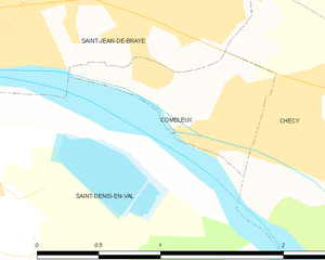
Combleux
- commune in Loiret, France
- Country:
- Postal Code: 45800
- Coordinates: 47° 53' 59" N, 1° 59' 26" E
- GPS tracks (wikiloc): [Link]
- Area: 1.1 sq km
- Population: 509


Chécy
- commune in Loiret, France
- Country:
- Postal Code: 45430
- Coordinates: 47° 53' 37" N, 2° 1' 37" E
- GPS tracks (wikiloc): [Link]
- Area: 15.47 sq km
- Population: 8791
- Web site: [Link]


Saint-Jean-de-Braye
- commune in Loiret, France
- Country:
- Postal Code: 45800
- Coordinates: 47° 54' 43" N, 1° 58' 16" E
- GPS tracks (wikiloc): [Link]
- AboveSeaLevel: 100 м m
- Area: 13.7 sq km
- Population: 20123
- Web site: [Link]