Saint-Georges-sur-Cher (Saint-Georges-sur-Cher)

- commune in Loir-et-Cher, France
- Country:

- Postal Code: 41400
- Coordinates: 47° 19' 31" N, 1° 7' 31" E


- GPS tracks (wikiloc): [Link]
- Area: 23.78 sq km
- Population: 2645
- Web site: http://www.saintgeorgessurcher.net
- Wikipedia en: wiki(en)
- Wikipedia: wiki(fr)
- Wikidata storage: Wikidata: Q1170542
- Wikipedia Commons Category: [Link]
- Freebase ID: [/m/03nw28c]
- GeoNames ID: Alt: [2979892]
- SIREN number: [214102113]
- BnF ID: [15259485q]
- INSEE municipality code: 41211
Shares border with regions:


Francueil
- commune in Indre-et-Loire, France
- Country:
- Postal Code: 37150
- Coordinates: 47° 18' 43" N, 1° 4' 58" E
- GPS tracks (wikiloc): [Link]
- Area: 12.91 sq km
- Population: 1363
- Web site: [Link]


Céré-la-Ronde
- commune in Indre-et-Loire, France
- Country:
- Postal Code: 37460
- Coordinates: 47° 15' 38" N, 1° 11' 24" E
- GPS tracks (wikiloc): [Link]
- Area: 49.2 sq km
- Population: 450
- Web site: [Link]

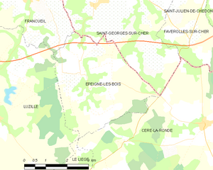
Épeigné-les-Bois
- commune in Indre-et-Loire, France
- Country:
- Postal Code: 37150
- Coordinates: 47° 16' 50" N, 1° 6' 39" E
- GPS tracks (wikiloc): [Link]
- Area: 14.52 sq km
- Population: 449
- Web site: [Link]


Faverolles-sur-Cher
- commune in Loir-et-Cher, France
- Country:
- Postal Code: 41400
- Coordinates: 47° 19' 17" N, 1° 11' 8" E
- GPS tracks (wikiloc): [Link]
- Area: 15.51 sq km
- Population: 1357


Chisseaux
- commune in Indre-et-Loire, France
- Country:
- Postal Code: 37150
- Coordinates: 47° 19' 52" N, 1° 5' 35" E
- GPS tracks (wikiloc): [Link]
- Area: 11.8 sq km
- Population: 626
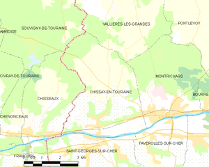
Chissay-en-Touraine
- commune in Loir-et-Cher, France
- Country:
- Postal Code: 41400
- Coordinates: 47° 20' 14" N, 1° 7' 59" E
- GPS tracks (wikiloc): [Link]
- Area: 18.17 sq km
- Population: 1168
- Web site: [Link]