Francueil (Francueil)

- commune in Indre-et-Loire, France
- Country:

- Postal Code: 37150
- Coordinates: 47° 18' 43" N, 1° 4' 58" E


- GPS tracks (wikiloc): [Link]
- Area: 12.91 sq km
- Population: 1363
- Web site: http://www.francueil.fr/
- Wikipedia en: wiki(en)
- Wikipedia: wiki(fr)
- Wikidata storage: Wikidata: Q1135876
- Wikipedia Commons Category: [Link]
- Freebase ID: [/m/03nvfnq]
- GeoNames ID: Alt: [6433024]
- SIREN number: [213701105]
- BnF ID: [15257661s]
- VIAF ID: Alt: [141162457]
- Library of Congress authority ID: Alt: [nr92027808]
- INSEE municipality code: 37110
Shares border with regions:


Civray-de-Touraine
- commune in Indre-et-Loire, France
- Country:
- Postal Code: 37150
- Coordinates: 47° 19' 56" N, 1° 2' 55" E
- GPS tracks (wikiloc): [Link]
- Area: 22.88 sq km
- Population: 1845
- Web site: [Link]

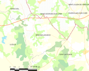
Épeigné-les-Bois
- commune in Indre-et-Loire, France
- Country:
- Postal Code: 37150
- Coordinates: 47° 16' 50" N, 1° 6' 39" E
- GPS tracks (wikiloc): [Link]
- Area: 14.52 sq km
- Population: 449
- Web site: [Link]

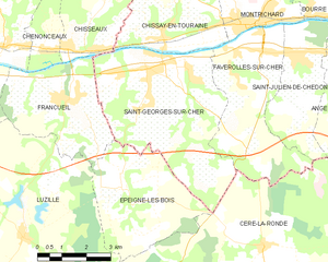
Saint-Georges-sur-Cher
- commune in Loir-et-Cher, France
- Country:
- Postal Code: 41400
- Coordinates: 47° 19' 31" N, 1° 7' 31" E
- GPS tracks (wikiloc): [Link]
- Area: 23.78 sq km
- Population: 2645
- Web site: [Link]


Luzillé
- commune in Indre-et-Loire, France
- Country:
- Postal Code: 37150
- Coordinates: 47° 15' 44" N, 1° 3' 37" E
- GPS tracks (wikiloc): [Link]
- Area: 40.68 sq km
- Population: 981
- Web site: [Link]

Chenonceaux
- commune in Indre-et-Loire, France
- Country:
- Postal Code: 37150
- Coordinates: 47° 19' 55" N, 1° 4' 6" E
- GPS tracks (wikiloc): [Link]
- Area: 4.33 sq km
- Population: 351


Chisseaux
- commune in Indre-et-Loire, France
- Country:
- Postal Code: 37150
- Coordinates: 47° 19' 52" N, 1° 5' 35" E
- GPS tracks (wikiloc): [Link]
- Area: 11.8 sq km
- Population: 626