Saint-Gervasy (Saint-Gervasy)

- commune in Gard, France
- Country:

- Postal Code: 30320
- Coordinates: 43° 52' 39" N, 4° 28' 7" E


- GPS tracks (wikiloc): [Link]
- Area: 6.93 sq km
- Population: 1853
- Web site: http://www.mairie-saint-gervasy.com
- Wikipedia en: wiki(en)
- Wikipedia: wiki(fr)
- Wikidata storage: Wikidata: Q379622
- Wikipedia Commons Category: [Link]
- Freebase ID: [/m/03c7_2s]
- GeoNames ID: Alt: [6431401]
- SIREN number: [213002579]
- BnF ID: [15254897m]
- PACTOLS thesaurus ID: [pcrtfYGTBLRX2j]
- INSEE municipality code: 30257
Shares border with regions:


Marguerittes
- commune in Gard, France
- Country:
- Postal Code: 30320
- Coordinates: 43° 51' 36" N, 4° 26' 38" E
- GPS tracks (wikiloc): [Link]
- Area: 25.29 sq km
- Population: 8584
- Web site: [Link]


Bezouce
- commune in Gard, France
- Country:
- Postal Code: 30320
- Coordinates: 43° 52' 53" N, 4° 29' 24" E
- GPS tracks (wikiloc): [Link]
- Area: 12.29 sq km
- Population: 2265
- Web site: [Link]

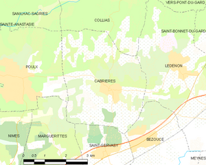
Cabrières
- commune in Gard, France
- Country:
- Postal Code: 30210
- Coordinates: 43° 54' 17" N, 4° 28' 18" E
- GPS tracks (wikiloc): [Link]
- Area: 14.76 sq km
- Population: 1600