Saint-Jean-Saint-Nicolas (Saint-Jean-Saint-Nicolas)
- commune in Hautes-Alpes, France
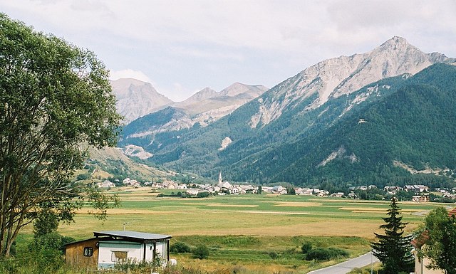
 Hiking in Saint-Jean-Saint-Nicolas
Saint-Jean-Saint-Nicolas is a charming village located in the Hautes-Alpes region of France, and it's an excellent destination for hiking enthusiasts. Nestled at the foot of the Écrins mountain range, the area is known for its stunning natural scenery, diverse landscapes, and a variety of hiking trails suitable for different skill levels.
Hiking Trails
-
Discovery Trails: There are several marked trails around the village that offer a gentle introduction to hiking, perfect for families or casual hikers. These trails typically wind through meadows and forests, providing beautiful views of the surrounding mountains.
-
Moderate Hikes: For those looking for something a bit more challenging, trails leading to nearby peaks, such as Montagne de Charance or the surrounding ridges offer moderately difficult hikes with spectacular panoramic views.
-
Advanced Routes: Experienced hikers can tackle more challenging routes, such as those leading into the Écrins National Park. These trails may involve steeper ascents and can lead to breathtaking alpine lakes or mountain summits.
Highlights of Hiking in the Area
-
Scenic Views: The hiking trails often provide stunning vistas of the Écrins mountain range, glacial lakes, and lush valleys.
-
Flora and Fauna: The diverse ecosystems support a variety of wildlife and plant species, making hikes an opportunity for nature observation.
-
Cultural Heritage: Along the trails, you might encounter traditional mountain villages and historical sites, providing insight into the local culture and history.
Practical Considerations
-
Preparation: Always check the weather conditions and trail status before you head out. Some trails may be subject to seasonal closures or may require specific gear.
-
Safety: Familiarize yourself with the area and prepare for changing weather conditions. Carry adequate water, snacks, and first-aid supplies.
-
Guided Tours: If you're unfamiliar with the area or new to hiking, consider joining a guided hike. Local guides can provide valuable insights and ensure your safety on the trails.
Best Time to Hike
The best hiking season in Saint-Jean-Saint-Nicolas typically spans from late spring to early autumn (May to October), when the weather is generally mild, and the trails are accessible.
Hiking in and around Saint-Jean-Saint-Nicolas promises an unforgettable experience amidst stunning landscapes and a rich natural environment!
- Country:

- Postal Code: 05260
- Coordinates: 44° 40' 3" N, 6° 13' 43" E


- GPS tracks (wikiloc): [Link]
- Area: 37.17 sq km
- Population: 997
- Wikipedia en: wiki(en)
- Wikipedia: wiki(fr)
- Wikidata storage: Wikidata: Q1086014
- Wikipedia Commons Category: [Link]
- Freebase ID: [/m/03mfp1m]
- Freebase ID: [/m/03mfp1m]
- GeoNames ID: Alt: [2979198]
- GeoNames ID: Alt: [2979198]
- SIREN number: [210501458]
- SIREN number: [210501458]
- INSEE municipality code: 05145
- INSEE municipality code: 05145
Shares border with regions:
Ancelle
- commune in Hautes-Alpes, France
Hiking in Ancelle
Ancelle is a charming village located in the French Alps, specifically in the Hautes-Alpes department. It's a great destination for hiking enthusiasts looking for a mix of natural beauty, alpine scenery, and a variety of trails suitable for different skill levels. Here are some insights into hiking in Ancelle:...
- Country:
- Postal Code: 05260
- Coordinates: 44° 37' 24" N, 6° 12' 24" E
- GPS tracks (wikiloc): [Link]
- Area: 50.66 sq km
- Population: 905

Chabottes
- commune in Hautes-Alpes, France
Hiking in Chabottes
Chabottes is a charming village located in the Hautes-Alpes region of France, nestled in the stunning French Alps. The area around Chabottes offers a variety of hiking trails suitable for different skill levels, making it a great destination for outdoor enthusiasts....
- Country:
- Postal Code: 05260
- Coordinates: 44° 38' 37" N, 6° 10' 15" E
- GPS tracks (wikiloc): [Link]
- Area: 9.96 sq km
- Population: 834

Orcières
- commune in Hautes-Alpes, France
Hiking in Orcières
Orcières is a stunning destination located in the French Alps, nestled within the Écrins National Park in the Haute-Alpes region. It offers a variety of hiking opportunities suitable for all levels of experience. Here are some key points to consider:...
- Country:
- Postal Code: 05170
- Coordinates: 44° 41' 4" N, 6° 19' 30" E
- GPS tracks (wikiloc): [Link]
- Area: 98.27 sq km
- Population: 715

Saint-Michel-de-Chaillol
- commune in Hautes-Alpes, France
Hiking in Saint-Michel-de-Chaillol
Saint-Michel-de-Chaillol is a charming village located in the French Alps, specifically in the Hautes-Alpes department of southeastern France. The area is known for its breathtaking landscapes, making it a wonderful destination for hiking enthusiasts....
- Country:
- Postal Code: 05260
- Coordinates: 44° 40' 56" N, 6° 10' 3" E
- GPS tracks (wikiloc): [Link]
- Area: 16.78 sq km
- Population: 315

Saint-Léger-les-Mélèzes
- commune in Hautes-Alpes, France
Hiking in Saint-Léger-les-Mélèzes
Saint-Léger-les-Mélèzes is a charming alpine village located in the Hautes-Alpes region of southeastern France. It's an excellent destination for hiking enthusiasts, offering a mix of scenic trails, beautiful landscapes, and a variety of outdoor activities....
- Country:
- Postal Code: 05260
- Coordinates: 44° 38' 38" N, 6° 11' 54" E
- GPS tracks (wikiloc): [Link]
- Area: 6.76 sq km
- Population: 345
- Web site: [Link]

Champoléon
- commune in Hautes-Alpes, France
Hiking in Champoléon
Champoléon is a beautiful valley located in the Écrins National Park in the French Alps, known for its stunning landscapes, diverse flora and fauna, and a variety of hiking trails suitable for different skill levels. Here are some key points to consider when hiking in Champoléon:...
- Country:
- Postal Code: 05260
- Coordinates: 44° 43' 14" N, 6° 15' 40" E
- GPS tracks (wikiloc): [Link]
- Area: 98.54 sq km
- Population: 148