Saint-Léger-les-Mélèzes (Saint-Léger-les-Mélèzes)
- commune in Hautes-Alpes, France
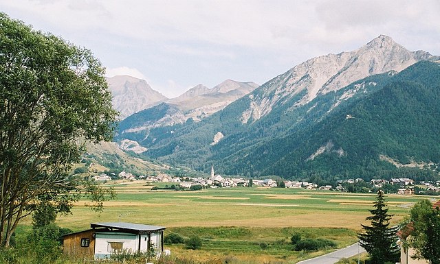
 Hiking in Saint-Léger-les-Mélèzes
Saint-Léger-les-Mélèzes is a charming alpine village located in the Hautes-Alpes region of southeastern France. It's an excellent destination for hiking enthusiasts, offering a mix of scenic trails, beautiful landscapes, and a variety of outdoor activities.
Hiking Trails
-
Les Balcons du Méane: This is a popular hike that showcases stunning views of the surrounding mountains and valleys. The trail is well-marked and suitable for hikers of varying skill levels. It's a great option for families or those looking for a leisurely walk.
-
The GR 94: Part of the long-distance hiking trails in France, the GR 94 passes through the area and provides access to a more challenging and extensive hiking experience. It connects various valleys and offers breathtaking views along the way.
-
Montagne de Faraud: For more adventurous hikers, the ascent to Montagne de Faraud provides a challenging climb with rewarding panoramic views at the summit. This trail is typically recommended for experienced hikers due to its elevation changes and rugged terrain.
-
La Forêt de la Méouge: This trail takes you through a beautiful forest area with a chance to spot local wildlife. The understory is rich in flora, making it a lovely hike in the spring and summer months.
Best Time to Hike
The best times for hiking in Saint-Léger-les-Mélèzes are during late spring (May to June) and early autumn (September to October). Summer can be hot, but it’s also a great time to enjoy the lush green landscapes and clear skies. Winter is generally not ideal for hiking in the high altitudes due to snow, but snowshoeing and winter hiking can be enjoyed in the lower trails.
Preparation and Safety
- Gear: Ensure you have proper hiking footwear, weather-appropriate clothing, and plenty of water. Hiking poles can be beneficial for steep trails.
- Navigation: While many trails are well-marked, carrying a map and a compass or a GPS device is always a good idea.
- Weather: Be mindful of changes in weather. The mountains can have unpredictable weather, so it's essential to check forecasts before heading out.
Other Activities
Besides hiking, Saint-Léger-les-Mélèzes offers other outdoor activities such as mountain biking, rock climbing, and, in the winter, skiing and snowboarding. The landscape is stunning year-round, making it an attractive destination for nature lovers.
Local Recommendations
Don't forget to explore the village itself, which has local shops and eateries where you can enjoy traditional alpine cuisine and hospitality. It's a great way to unwind after a day on the trails.
Overall, Saint-Léger-les-Mélèzes is a fantastic spot for hikers looking for diverse trails and stunning alpine scenery. Whether you are a seasoned hiker or a casual walker, you will find something to enjoy in this beautiful area!
- Country:

- Postal Code: 05260
- Coordinates: 44° 38' 38" N, 6° 11' 54" E


- GPS tracks (wikiloc): [Link]
- Area: 6.76 sq km
- Population: 345
- Web site: http://www.st-leger05.fr
- Wikipedia en: wiki(en)
- Wikipedia: wiki(fr)
- Wikidata storage: Wikidata: Q1085971
- Wikipedia Commons Category: [Link]
- Freebase ID: [/m/03mfn_x]
- Freebase ID: [/m/03mfn_x]
- GeoNames ID: Alt: [2978816]
- GeoNames ID: Alt: [2978816]
- SIREN number: [210501490]
- SIREN number: [210501490]
- INSEE municipality code: 05149
- INSEE municipality code: 05149
Shares border with regions:
Ancelle
- commune in Hautes-Alpes, France
Hiking in Ancelle
Ancelle is a charming village located in the French Alps, specifically in the Hautes-Alpes department. It's a great destination for hiking enthusiasts looking for a mix of natural beauty, alpine scenery, and a variety of trails suitable for different skill levels. Here are some insights into hiking in Ancelle:...
- Country:
- Postal Code: 05260
- Coordinates: 44° 37' 24" N, 6° 12' 24" E
- GPS tracks (wikiloc): [Link]
- Area: 50.66 sq km
- Population: 905

Chabottes
- commune in Hautes-Alpes, France
Hiking in Chabottes
Chabottes is a charming village located in the Hautes-Alpes region of France, nestled in the stunning French Alps. The area around Chabottes offers a variety of hiking trails suitable for different skill levels, making it a great destination for outdoor enthusiasts....
- Country:
- Postal Code: 05260
- Coordinates: 44° 38' 37" N, 6° 10' 15" E
- GPS tracks (wikiloc): [Link]
- Area: 9.96 sq km
- Population: 834

Saint-Jean-Saint-Nicolas
- commune in Hautes-Alpes, France
Hiking in Saint-Jean-Saint-Nicolas
Saint-Jean-Saint-Nicolas is a charming village located in the Hautes-Alpes region of France, and it's an excellent destination for hiking enthusiasts. Nestled at the foot of the Écrins mountain range, the area is known for its stunning natural scenery, diverse landscapes, and a variety of hiking trails suitable for different skill levels....
- Country:
- Postal Code: 05260
- Coordinates: 44° 40' 3" N, 6° 13' 43" E
- GPS tracks (wikiloc): [Link]
- Area: 37.17 sq km
- Population: 997