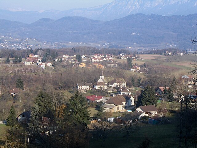
Saint-Jean-d'Avelanne (Saint-Jean-d'Avelanne)

- commune in Isère, France
 Hiking in Saint-Jean-d'Avelanne
Saint-Jean-d'Avelanne is a charming commune located in the Isère department of the Auvergne-Rhône-Alpes region in southeastern France. Surrounded by beautiful natural landscapes, it offers several opportunities for hiking and outdoor activities.
Hiking Opportunities:
-
Scenic Trails: The area around Saint-Jean-d'Avelanne has a variety of trails suitable for different skill levels. You can find peaceful paths through forests, meadows, and rolling hills, as well as more challenging routes that lead to panoramic viewpoints.
-
Natural Reserves and Parks: The nearby Chartreuse and Vercors mountains offer stunning hikes. The Chartreuse Regional Natural Park is famous for its limestone cliffs and deep gorges, while the Vercors Regional Natural Park is known for its beautiful landscapes and biodiversity.
-
Hiking Duration and Difficulty: Various trails can provide options for short, leisurely hikes or longer, more strenuous treks. Make sure to assess your fitness level and choose trails that match your ability.
-
Navigation: Pay attention to local maps and trail markers. It’s a good idea to carry a GPS device, smartphone app, or a physical map that shows the hiking routes to ensure you stay on track.
-
Wildlife and Flora: Hiking in this region provides the chance to encounter diverse wildlife and enjoy a variety of flora, especially during the spring and summer months when wildflowers bloom.
Preparation Tips:
- Seasonal Considerations: Check the weather and trail conditions before heading out. Be mindful of seasonal challenges, such as snow in winter or rain in spring.
- Gear Up: Suitable hiking boots, clothing layers, water, snacks, and navigation tools are essential for a safe and enjoyable hike.
- Local Regulations: Always adhere to any local guidelines regarding trail usage and wildlife protection.
Nearby Attractions:
In addition to hiking, you can explore local cultural sites, charming villages, and enjoy the regional cuisine. The scenic beauty of the surrounding areas makes it a perfect destination for both avid hikers and those looking for a peaceful retreat in nature.
Make sure to research specific trails before going, as local tourism offices can provide updated information and maps. Enjoy your hiking adventure in Saint-Jean-d'Avelanne!
- Country:

- Postal Code: 38480
- Coordinates: 45° 30' 25" N, 5° 40' 23" E


- GPS tracks (wikiloc): [Link]
- Area: 7.85 sq km
- Population: 946
- Web site: http://st.jean.davelanne.pagesperso-orange.fr/index1.html
- Wikipedia en: wiki(en)
- Wikipedia: wiki(fr)
- Wikidata storage: Wikidata: Q1068525
- Wikipedia Commons Category: [Link]
- Freebase ID: [/m/0dt4l3]
- Freebase ID: [/m/0dt4l3]
- SIREN number: [213803984]
- SIREN number: [213803984]
- BnF ID: [15258208g]
- BnF ID: [15258208g]
- INSEE municipality code: 38398
- INSEE municipality code: 38398
Shares border with regions:
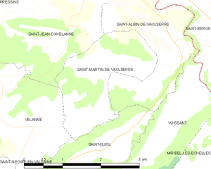
Saint-Martin-de-Vaulserre
- commune in Isère, France
Hiking in Saint-Martin-de-Vaulserre
Saint-Martin-de-Vaulserre is a charming commune located in the Isère department of the Auvergne-Rhône-Alpes region in southeastern France. The area offers various hiking opportunities that showcase the beautiful landscapes of the French Alps....
- Country:
- Postal Code: 38480
- Coordinates: 45° 29' 39" N, 5° 40' 58" E
- GPS tracks (wikiloc): [Link]
- Area: 3.92 sq km
- Population: 262
- Web site: [Link]
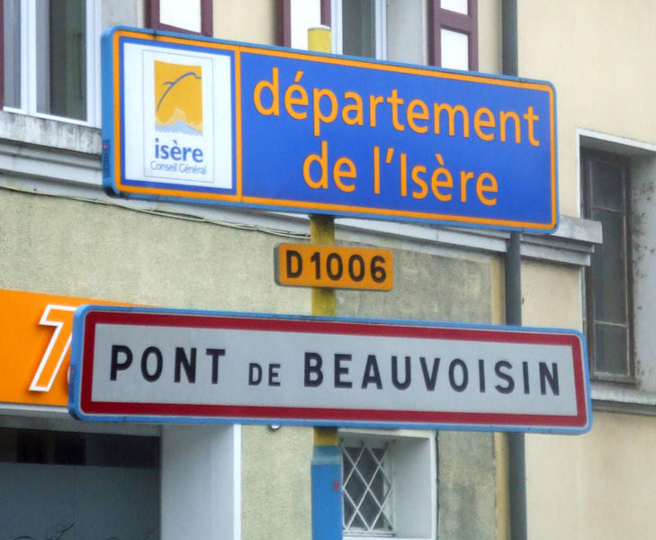

Le Pont-de-Beauvoisin
- commune in Isère, France
Hiking in Le Pont-de-Beauvoisin
Le Pont-de-Beauvoisin, located in the Isère department of France, is a charming small town that serves as a gateway to the beautiful landscapes of the Alps and the surrounding regions. Here are some highlights and tips for hiking in and around Le Pont-de-Beauvoisin:...
- Country:
- Postal Code: 38480
- Coordinates: 45° 32' 4" N, 5° 39' 59" E
- GPS tracks (wikiloc): [Link]
- Area: 7.36 sq km
- Population: 3574
- Web site: [Link]


Domessin
- commune in Savoie, France
Hiking in Domessin
Domessin is a quaint commune located in the Savoie department in the Auvergne-Rhône-Alpes region of southeastern France. Nestled at the foot of the Chartreuse Mountains, this area offers a variety of hiking opportunities that cater to different skill levels....
- Country:
- Postal Code: 73330
- Coordinates: 45° 32' 25" N, 5° 42' 33" E
- GPS tracks (wikiloc): [Link]
- Area: 9.83 sq km
- Population: 1839
- Web site: [Link]


Pressins
- commune in Isère, France
Hiking in Pressins
Pressins is a charming commune located in the Isère department of southeastern France. It's a lesser-known destination for hikers, but it offers access to beautiful landscapes typical of the French Alps and surrounding regions. Here are some key points to consider if you're planning a hiking trip in and around Pressins:...
- Country:
- Postal Code: 38480
- Coordinates: 45° 31' 32" N, 5° 37' 38" E
- GPS tracks (wikiloc): [Link]
- Area: 10.1 sq km
- Population: 1147
- Web site: [Link]


Saint-Albin-de-Vaulserre
- commune in Isère, France
Hiking in Saint-Albin-de-Vaulserre
Saint-Albin-de-Vaulserre is a charming commune located in the Isère department in the Auvergne-Rhône-Alpes region of southeastern France. While it is not as well-known as other hiking destinations, it offers beautiful rural landscapes and access to outdoor activities that can be enjoyed by hikers of all levels....
- Country:
- Postal Code: 38480
- Coordinates: 45° 30' 17" N, 5° 42' 9" E
- GPS tracks (wikiloc): [Link]
- Area: 4.99 sq km
- Population: 400


Velanne
- commune in Isère, France
Hiking in Velanne
Velanne is a charming village located in the French Alps, nestled within the picturesque Isère department. While not as widely known as some of its neighboring areas, it offers access to beautiful landscapes and hiking opportunities perfect for outdoor enthusiasts....
- Country:
- Postal Code: 38620
- Coordinates: 45° 29' 18" N, 5° 38' 54" E
- GPS tracks (wikiloc): [Link]
- Area: 8.04 sq km
- Population: 524