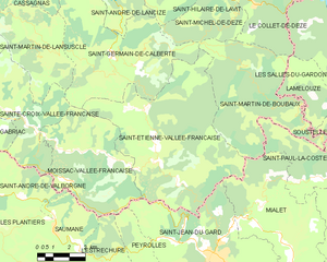
Saint-Jean-du-Gard (Saint-Jean-du-Gard)

- commune in Gard, France
- Country:

- Postal Code: 30270
- Coordinates: 44° 6' 17" N, 3° 53' 10" E


- GPS tracks (wikiloc): [Link]
- Area: 41.64 sq km
- Population: 2610
- Web site: http://www.ville-saintjeandugard.fr
- Wikipedia en: wiki(en)
- Wikipedia: wiki(fr)
- Wikidata storage: Wikidata: Q268590
- Wikipedia Commons Category: [Link]
- Freebase ID: [/m/0css6p]
- GeoNames ID: Alt: [2979244]
- SIREN number: [213002694]
- BnF ID: [15254909s]
- VIAF ID: Alt: [124360145]
- Library of Congress authority ID: Alt: [n78058426]
- INSEE municipality code: 30269
Shares border with regions:


Moissac-Vallée-Française
- commune in Lozère, France
- Country:
- Postal Code: 48110
- Coordinates: 44° 9' 47" N, 3° 47' 4" E
- GPS tracks (wikiloc): [Link]
- AboveSeaLevel: 300 м m
- Area: 27.05 sq km
- Population: 223
- Web site: [Link]


Mialet
- commune in Gard, France
- Country:
- Postal Code: 30140
- Coordinates: 44° 6' 39" N, 3° 56' 35" E
- GPS tracks (wikiloc): [Link]
- Area: 30.76 sq km
- Population: 612
- Web site: [Link]


Thoiras
- commune in Gard, France
- Country:
- Postal Code: 30140
- Coordinates: 44° 3' 55" N, 3° 55' 40" E
- GPS tracks (wikiloc): [Link]
- Area: 22.89 sq km
- Population: 441
- Web site: [Link]

Saint-Étienne-Vallée-Française
- commune in Lozère, France
- Country:
- Postal Code: 48330
- Coordinates: 44° 9' 59" N, 3° 50' 32" E
- GPS tracks (wikiloc): [Link]
- AboveSeaLevel: 245 м m
- Area: 50.99 sq km
- Population: 515
- Web site: [Link]
Peyrolles
- commune in Gard, France
- Country:
- Postal Code: 30124
- Coordinates: 44° 6' 39" N, 3° 49' 57" E
- GPS tracks (wikiloc): [Link]
- Area: 8.29 sq km
- Population: 36
- Web site: [Link]


Sainte-Croix-de-Caderle
- commune in Gard, France
- Country:
- Postal Code: 30460
- Coordinates: 44° 4' 12" N, 3° 51' 54" E
- GPS tracks (wikiloc): [Link]
- AboveSeaLevel: 530 м m
- Area: 7.63 sq km
- Population: 117