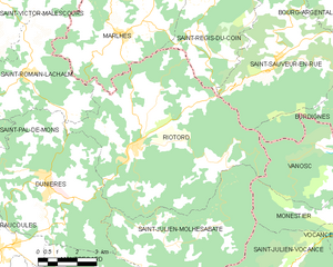
Saint-Julien-Molhesabate (Saint-Julien-Molhesabate)

- commune in Haute-Loire, France
- Country:

- Postal Code: 43220
- Coordinates: 45° 11' 10" N, 4° 25' 35" E


- GPS tracks (wikiloc): [Link]
- Area: 27.5 sq km
- Population: 173
- Wikipedia en: wiki(en)
- Wikipedia: wiki(fr)
- Wikidata storage: Wikidata: Q534103
- Wikipedia Commons Category: [Link]
- Freebase ID: [/m/03ntp6v]
- GeoNames ID: Alt: [6434429]
- SIREN number: [214302044]
- BnF ID: [15260108g]
- INSEE municipality code: 43204
Shares border with regions:


Saint-Bonnet-le-Froid
- commune in Haute-Loire, France
- Country:
- Postal Code: 43290
- Coordinates: 45° 8' 33" N, 4° 26' 7" E
- GPS tracks (wikiloc): [Link]
- Area: 13.09 sq km
- Population: 261


Montregard
- commune in Haute-Loire, France
- Country:
- Postal Code: 43290
- Coordinates: 45° 9' 31" N, 4° 20' 48" E
- GPS tracks (wikiloc): [Link]
- Area: 39.93 sq km
- Population: 607

Riotord
- commune in Haute-Loire, France
- Country:
- Postal Code: 43220
- Coordinates: 45° 13' 54" N, 4° 24' 7" E
- GPS tracks (wikiloc): [Link]
- Area: 51.88 sq km
- Population: 1179


Dunières
- commune in Haute-Loire, France
- Country:
- Postal Code: 43220
- Coordinates: 45° 12' 56" N, 4° 20' 41" E
- GPS tracks (wikiloc): [Link]
- Area: 34.75 sq km
- Population: 2856
- Web site: [Link]

Saint-Julien-Vocance
- commune in Ardèche, France
- Country:
- Postal Code: 07690
- Coordinates: 45° 10' 31" N, 4° 30' 11" E
- GPS tracks (wikiloc): [Link]
- Area: 26.42 sq km
- Population: 229

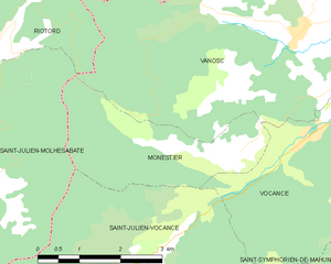
Monestier
- commune in Ardèche, France
- Country:
- Postal Code: 07690
- Coordinates: 45° 11' 55" N, 4° 31' 52" E
- GPS tracks (wikiloc): [Link]
- Area: 7.41 sq km
- Population: 57