Dunières (Dunières)

- commune in Haute-Loire, France
- Country:

- Postal Code: 43220
- Coordinates: 45° 12' 56" N, 4° 20' 41" E


- GPS tracks (wikiloc): [Link]
- Area: 34.75 sq km
- Population: 2856
- Web site: http://www.dunieres43.fr
- Wikipedia en: wiki(en)
- Wikipedia: wiki(fr)
- Wikidata storage: Wikidata: Q271069
- Wikipedia Commons Category: [Link]
- Freebase ID: [/m/03ntmc8]
- GeoNames ID: Alt: [6449060]
- SIREN number: [214300873]
- BnF ID: [15259992c]
- VIAF ID: Alt: [248224456]
- INSEE municipality code: 43087
Shares border with regions:

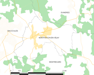
Montfaucon-en-Velay
- commune in Haute-Loire, France
- Country:
- Postal Code: 43290
- Coordinates: 45° 11' 6" N, 4° 18' 49" E
- GPS tracks (wikiloc): [Link]
- AboveSeaLevel: 914 м m
- Area: 4.99 sq km
- Population: 1257
Raucoules
- commune in Haute-Loire, France
- Country:
- Postal Code: 43290
- Coordinates: 45° 11' 15" N, 4° 17' 42" E
- GPS tracks (wikiloc): [Link]
- Area: 21.01 sq km
- Population: 911

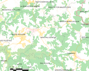
Saint-Pal-de-Mons
- commune in Haute-Loire, France
- Country:
- Postal Code: 43620
- Coordinates: 45° 14' 47" N, 4° 16' 27" E
- GPS tracks (wikiloc): [Link]
- Area: 27.11 sq km
- Population: 2272
- Web site: [Link]


Montregard
- commune in Haute-Loire, France
- Country:
- Postal Code: 43290
- Coordinates: 45° 9' 31" N, 4° 20' 48" E
- GPS tracks (wikiloc): [Link]
- Area: 39.93 sq km
- Population: 607

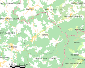
Riotord
- commune in Haute-Loire, France
- Country:
- Postal Code: 43220
- Coordinates: 45° 13' 54" N, 4° 24' 7" E
- GPS tracks (wikiloc): [Link]
- Area: 51.88 sq km
- Population: 1179
Saint-Julien-Molhesabate
- commune in Haute-Loire, France
- Country:
- Postal Code: 43220
- Coordinates: 45° 11' 10" N, 4° 25' 35" E
- GPS tracks (wikiloc): [Link]
- Area: 27.5 sq km
- Population: 173


Saint-Romain-Lachalm
- commune in Haute-Loire, France
- Country:
- Postal Code: 43620
- Coordinates: 45° 15' 58" N, 4° 20' 3" E
- GPS tracks (wikiloc): [Link]
- Area: 19.02 sq km
- Population: 1071