Saint-Léonard (Saint-Léonard)

- commune in Vosges, France
- Country:

- Postal Code: 88650
- Coordinates: 48° 12' 59" N, 6° 56' 38" E


- GPS tracks (wikiloc): [Link]
- Area: 14.57 sq km
- Population: 1355
- Web site: http://www.ville-saintleonard.fr
- Wikipedia en: wiki(en)
- Wikipedia: wiki(fr)
- Wikidata storage: Wikidata: Q1158103
- Wikipedia Commons Category: [Link]
- Freebase ID: [/m/03qgym0]
- Freebase ID: [/m/03qgym0]
- GeoNames ID: Alt: [6445729]
- GeoNames ID: Alt: [6445729]
- SIREN number: [218804235]
- SIREN number: [218804235]
- BnF ID: [15279342k]
- BnF ID: [15279342k]
- INSEE municipality code: 88423
- INSEE municipality code: 88423
Shares border with regions:

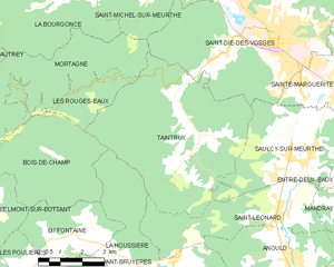
Taintrux
- commune in Vosges, France
- Country:
- Postal Code: 88100
- Coordinates: 48° 14' 59" N, 6° 54' 8" E
- GPS tracks (wikiloc): [Link]
- Area: 31.69 sq km
- Population: 1558


Saulcy-sur-Meurthe
- commune in Vosges, France
- Country:
- Postal Code: 88580
- Coordinates: 48° 14' 11" N, 6° 57' 35" E
- GPS tracks (wikiloc): [Link]
- Area: 16.37 sq km
- Population: 2339
- Web site: [Link]


Entre-deux-Eaux
- commune in Vosges, France
- Country:
- Postal Code: 88650
- Coordinates: 48° 13' 53" N, 6° 59' 31" E
- GPS tracks (wikiloc): [Link]
- Area: 8.47 sq km
- Population: 516

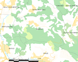
Mandray
- commune in Vosges, France
- Country:
- Postal Code: 88650
- Coordinates: 48° 13' 6" N, 6° 59' 45" E
- GPS tracks (wikiloc): [Link]
- Area: 12.36 sq km
- Population: 594
- Web site: [Link]


Anould
- commune in Vosges, France
- Country:
- Postal Code: 88650
- Coordinates: 48° 11' 8" N, 6° 56' 44" E
- GPS tracks (wikiloc): [Link]
- Area: 24.23 sq km
- Population: 3355
- Web site: [Link]

La Houssière
- commune in Vosges, France
- Country:
- Postal Code: 88430
- Coordinates: 48° 11' 43" N, 6° 51' 14" E
- GPS tracks (wikiloc): [Link]
- Area: 19.54 sq km
- Population: 598


Fraize
- commune in Vosges, France
- Country:
- Postal Code: 88230
- Coordinates: 48° 11' 9" N, 7° 0' 5" E
- GPS tracks (wikiloc): [Link]
- Area: 15.59 sq km
- Population: 2959
- Web site: [Link]