Saint-Maurice-en-Valgodemard (Saint-Maurice-en-Valgodemard)
- commune in Hautes-Alpes, France
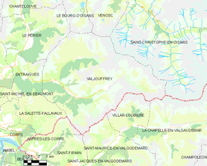
 Hiking in Saint-Maurice-en-Valgodemard
Saint-Maurice-en-Valgodemard is a beautiful village located in the French Alps, in the Hautes-Alpes department. Known for its stunning landscapes, it serves as an excellent base for various hiking adventures. Here are some key highlights for hiking in the area:
Trails and Routes
-
GR50 Grand Tour des Écrins: Part of the long-distance hiking network, this route takes you through the Écrins National Park. You'll enjoy breathtaking views of rugged mountains, alpine meadows, and glacial lakes.
-
Local Trails: There are many well-maintained local trails suitable for various skill levels. Trails ranging from easy walks to challenging hikes are abundant. The area provides marked paths that help navigate the stunning terrain.
-
Le Col de la Pousterle: A popular hike that rewards you with panoramic views from the mountain passes. It’s a moderately difficult trek, making it suited to those with some hiking experience.
Natural Attractions
- Écrins National Park: Surrounding the area, the park is home to a rich diversity of flora and fauna. Keep an eye out for marmots, chamois, and various bird species.
- Lakes and Waterfalls: Many trails lead to picturesque mountain lakes and waterfalls, perfect spots for a rest or picnic.
Seasonality
- Summer Hiking: Typically from June to September, the best time to experience the area's lush landscapes.
- Winter Activities: While primarily a summer hiking destination, there are opportunities for snowshoeing and winter walks in the colder months.
Preparation Tips
- Weather: Always check local weather conditions before heading out. Mountain weather can change rapidly.
- Gear: Wear appropriate footwear and clothing, bring plenty of water, snacks, and a map or GPS device if you're exploring less marked trails.
- Safety: If you're unfamiliar with the area, consider hiring a local guide for the best experience and safety.
Accessibility
Saint-Maurice-en-Valgodemard is typically accessed by car, and there are parking areas available near trailheads. Ensure you plan for your transportation and trail access ahead of time.
Hiking in this region promises a blend of scenic beauty and outdoor adventure, making it a memorable experience for nature lovers and hiking enthusiasts alike!
- Country:

- Postal Code: 05800
- Coordinates: 44° 48' 14" N, 6° 5' 44" E


- GPS tracks (wikiloc): [Link]
- Area: 36.37 sq km
- Population: 133
- Wikipedia en: wiki(en)
- Wikipedia: wiki(fr)
- Wikidata storage: Wikidata: Q1085854
- Wikipedia Commons Category: [Link]
- Freebase ID: [/m/03mfnzj]
- Freebase ID: [/m/03mfnzj]
- GeoNames ID: Alt: [6425640]
- GeoNames ID: Alt: [6425640]
- SIREN number: [210501524]
- SIREN number: [210501524]
- PACTOLS thesaurus ID: [pcrtPcj8yz5cdM]
- PACTOLS thesaurus ID: [pcrtPcj8yz5cdM]
- INSEE municipality code: 05152
- INSEE municipality code: 05152
Shares border with regions:

Saint-Jacques-en-Valgodemard
- commune in Hautes-Alpes, France
Hiking in Saint-Jacques-en-Valgodemard
Saint-Jacques-en-Valgodemard is a charming commune located in the Hautes-Alpes region of France, known for its breathtaking landscapes and exceptional hiking opportunities. Nestled in the Écrins National Park, this area is a haven for outdoor enthusiasts, offering a range of trails that cater to different skill levels....
- Country:
- Postal Code: 05800
- Coordinates: 44° 46' 34" N, 6° 2' 38" E
- GPS tracks (wikiloc): [Link]
- Area: 15.65 sq km
- Population: 147

Saint-Firmin
- commune in Hautes-Alpes, France
Hiking in Saint-Firmin
Saint-Firmin in the Hautes-Alpes region of France is a charming destination for hikers. Nestled in the Écrins National Park, this area is known for its stunning landscapes, rugged mountains, and rich biodiversity. Here are some key aspects to consider when hiking in and around Saint-Firmin:...
- Country:
- Postal Code: 05800
- Coordinates: 44° 46' 53" N, 6° 1' 45" E
- GPS tracks (wikiloc): [Link]
- AboveSeaLevel: 900 м m
- Area: 22.39 sq km
- Population: 468

Valjouffrey
- commune in Isère, France
Hiking in Valjouffrey
Valjouffrey is a beautiful and lesser-known hiking destination located in the Isère department of the Auvergne-Rhône-Alpes region in France. Nestled in the heart of the Vercors Massif, Valjouffrey offers stunning landscapes characterized by dramatic peaks, lush valleys, and serene alpine lakes, making it a perfect spot for outdoor enthusiasts....
- Country:
- Postal Code: 38740
- Coordinates: 44° 52' 20" N, 6° 1' 52" E
- GPS tracks (wikiloc): [Link]
- AboveSeaLevel: 1014 м m
- Area: 72.56 sq km
- Population: 145
- Web site: [Link]

Villar-Loubière
- commune in Hautes-Alpes, France
Hiking in Villar-Loubière
Villar-Loubière is a picturesque village located in the Provence-Alpes-Côte d'Azur region of southeastern France. It’s surrounded by stunning natural landscapes, making it a great destination for hiking enthusiasts....
- Country:
- Postal Code: 05800
- Coordinates: 44° 49' 34" N, 6° 8' 44" E
- GPS tracks (wikiloc): [Link]
- Area: 22.63 sq km
- Population: 42

La Motte-en-Champsaur
- commune in Hautes-Alpes, France
Hiking in La Motte-en-Champsaur
La Motte-en-Champsaur is a charming village located in the French Alps, known for its stunning natural scenery and a variety of hiking opportunities. The region offers a mix of landscapes, including alpine meadows, dense forests, and panoramic mountain views, making it an excellent destination for both novice and experienced hikers....
- Country:
- Postal Code: 05500
- Coordinates: 44° 43' 57" N, 6° 4' 5" E
- GPS tracks (wikiloc): [Link]
- Area: 52.8 sq km
- Population: 215
- Web site: [Link]

La Chapelle-en-Valgaudémar
- commune in Hautes-Alpes, France
Hiking in La Chapelle-en-Valgaudémar
La Chapelle-en-Valgaudémar is a picturesque village located in the heart of the Écrins National Park in the French Alps. This area is renowned for its stunning natural beauty, rugged mountains, and a variety of hiking trails suitable for different skill levels....
- Country:
- Postal Code: 05800
- Coordinates: 44° 49' 1" N, 6° 11' 41" E
- GPS tracks (wikiloc): [Link]
- AboveSeaLevel: 1050 м m
- Area: 108.02 sq km
- Population: 101