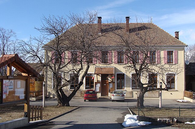
La Motte-en-Champsaur (La Motte-en-Champsaur)
- commune in Hautes-Alpes, France
 Hiking in La Motte-en-Champsaur
La Motte-en-Champsaur is a charming village located in the French Alps, known for its stunning natural scenery and a variety of hiking opportunities. The region offers a mix of landscapes, including alpine meadows, dense forests, and panoramic mountain views, making it an excellent destination for both novice and experienced hikers.
Hiking Trails
-
Champsaur Valley Trails: The trails in and around the Champsaur Valley provide a range of options from easy to moderate hikes. These trails often meander through beautiful landscapes with serene rivers and lush greenery.
-
Lac de la Muzelle: This hike takes you to the picturesque Lac de la Muzelle, set against a stunning mountain backdrop. The trail is moderately challenging but rewards hikers with breathtaking views and a peaceful lakeside experience.
-
Puy Saint Vincent: A bit further afield, the hikes around Puy Saint Vincent offer various trails with great elevation gain, ideal for those looking for a more strenuous outing.
-
Les Gorges de la Souloise: This hike along the Gorges de la Souloise is not only scenic but also features unique geological formations. The trail provides a mix of flat and hilly sections, making it suitable for different skill levels.
Tips for Hiking in La Motte-en-Champsaur
-
Season: The best time to hike in this region is during late spring to early fall (May to September), when the weather is mild and the trails are accessible.
-
Gear: Ensure you have appropriate hiking gear, including sturdy shoes, weather-appropriate clothing, a map or GPS device, plenty of water, and snacks.
-
Wildlife: Be prepared to encounter local wildlife, so be respectful of their habitat, and consider carrying bear spray if venturing into more remote areas.
-
Local Guides: For a more immersive experience, consider hiring a local guide. They can provide insight into the area’s flora, fauna, and history.
-
Trail Conditions: Always check the latest trail conditions and weather forecasts before heading out, as they can change rapidly in mountainous regions.
Hiking in La Motte-en-Champsaur can offer a wonderful experience in nature, showcasing some of the best that the French Alps have to offer. Enjoy your hike!
- Country:

- Postal Code: 05500
- Coordinates: 44° 43' 57" N, 6° 4' 5" E


- GPS tracks (wikiloc): [Link]
- Area: 52.8 sq km
- Population: 215
- Web site: http://www.la-motte-en-champsaur.com
- Wikipedia en: wiki(en)
- Wikipedia: wiki(fr)
- Wikidata storage: Wikidata: Q1086071
- Wikipedia Commons Category: [Link]
- Freebase ID: [/m/03mfmnd]
- Freebase ID: [/m/03mfmnd]
- GeoNames ID: Alt: [6456669]
- GeoNames ID: Alt: [6456669]
- SIREN number: [210500906]
- SIREN number: [210500906]
- PACTOLS thesaurus ID: [pcrtJdh1SZ2h1S]
- PACTOLS thesaurus ID: [pcrtJdh1SZ2h1S]
- INSEE municipality code: 05090
- INSEE municipality code: 05090
Shares border with regions:

Bénévent-et-Charbillac
- former commune in Hautes-Alpes, France
Hiking in Bénévent-et-Charbillac
Bénévent-et-Charbillac is a charming commune in the Drôme department of southeastern France, nestled in the beautiful landscape of the Vercors Massif. This region offers various opportunities for hiking enthusiasts, with trails that cater to different skill levels and preferences....
- Country:
- Postal Code: 05500
- Coordinates: 44° 41' 54" N, 6° 5' 12" E
- GPS tracks (wikiloc): [Link]
- AboveSeaLevel: 1120 м m
- Population: 274

Saint-Jacques-en-Valgodemard
- commune in Hautes-Alpes, France
Hiking in Saint-Jacques-en-Valgodemard
Saint-Jacques-en-Valgodemard is a charming commune located in the Hautes-Alpes region of France, known for its breathtaking landscapes and exceptional hiking opportunities. Nestled in the Écrins National Park, this area is a haven for outdoor enthusiasts, offering a range of trails that cater to different skill levels....
- Country:
- Postal Code: 05800
- Coordinates: 44° 46' 34" N, 6° 2' 38" E
- GPS tracks (wikiloc): [Link]
- Area: 15.65 sq km
- Population: 147

Saint-Bonnet-en-Champsaur
- former commune in Hautes-Alpes, France
Hiking in Saint-Bonnet-en-Champsaur
Saint-Bonnet-en-Champsaur, located in the Hautes-Alpes region of southeastern France, is a picturesque area that offers a variety of hiking opportunities. The region is known for its stunning alpine scenery, including mountains, rivers, and lush forests, making it a fantastic destination for outdoor enthusiasts....
- Country:
- Postal Code: 05500
- Coordinates: 44° 40' 55" N, 6° 4' 35" E
- GPS tracks (wikiloc): [Link]
- AboveSeaLevel: 1040 м m
- Area: 15.01 sq km
- Population: 2047
- Web site: [Link]

Saint-Michel-de-Chaillol
- commune in Hautes-Alpes, France
Hiking in Saint-Michel-de-Chaillol
Saint-Michel-de-Chaillol is a charming village located in the French Alps, specifically in the Hautes-Alpes department of southeastern France. The area is known for its breathtaking landscapes, making it a wonderful destination for hiking enthusiasts....
- Country:
- Postal Code: 05260
- Coordinates: 44° 40' 56" N, 6° 10' 3" E
- GPS tracks (wikiloc): [Link]
- Area: 16.78 sq km
- Population: 315

Saint-Maurice-en-Valgodemard
- commune in Hautes-Alpes, France
Hiking in Saint-Maurice-en-Valgodemard
Saint-Maurice-en-Valgodemard is a beautiful village located in the French Alps, in the Hautes-Alpes department. Known for its stunning landscapes, it serves as an excellent base for various hiking adventures. Here are some key highlights for hiking in the area:...
- Country:
- Postal Code: 05800
- Coordinates: 44° 48' 14" N, 6° 5' 44" E
- GPS tracks (wikiloc): [Link]
- Area: 36.37 sq km
- Population: 133
Saint-Eusèbe-en-Champsaur
- former commune in Hautes-Alpes, France
Hiking in Saint-Eusèbe-en-Champsaur
Saint-Eusèbe-en-Champsaur is a picturesque village located in the French Alps, in the Champsaur valley. It offers a variety of hiking opportunities for both novice and experienced hikers. Here are some highlights of hiking in this area:...
- Country:
- Postal Code: 05500
- Coordinates: 44° 43' 33" N, 6° 1' 39" E
- GPS tracks (wikiloc): [Link]
- Area: 7.83 sq km
- Population: 150
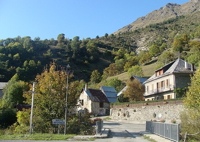
Les Infournas
- former commune in Hautes-Alpes, France
Hiking in Les Infournas
Les Infournas is a lesser-known yet stunning hiking destination located in the southern region of France, particularly in the Provence-Alpes-Côte d'Azur area. It is renowned for its rugged landscapes, striking rock formations, and a variety of trails that cater to different skill levels. Here are some key points to keep in mind if you're planning a hike there:...
- Country:
- Postal Code: 05500
- Coordinates: 44° 42' 57" N, 6° 5' 40" E
- GPS tracks (wikiloc): [Link]
- Area: 8.69 sq km
- Population: 24

Les Costes
- former commune in Hautes-Alpes, France
Hiking in Les Costes
Les Costes is a beautiful area that offers a range of hiking opportunities, characterized by its stunning landscapes and diverse terrain. While the specifics can vary depending on the exact location you're referring to, here's a general overview of what you might expect when hiking in a region like Les Costes:...
- Country:
- Postal Code: 05500
- Coordinates: 44° 44' 46" N, 6° 2' 2" E
- GPS tracks (wikiloc): [Link]
- Area: 8.78 sq km
- Population: 178

La Chapelle-en-Valgaudémar
- commune in Hautes-Alpes, France
Hiking in La Chapelle-en-Valgaudémar
La Chapelle-en-Valgaudémar is a picturesque village located in the heart of the Écrins National Park in the French Alps. This area is renowned for its stunning natural beauty, rugged mountains, and a variety of hiking trails suitable for different skill levels....
- Country:
- Postal Code: 05800
- Coordinates: 44° 49' 1" N, 6° 11' 41" E
- GPS tracks (wikiloc): [Link]
- AboveSeaLevel: 1050 м m
- Area: 108.02 sq km
- Population: 101

Champoléon
- commune in Hautes-Alpes, France
Hiking in Champoléon
Champoléon is a beautiful valley located in the Écrins National Park in the French Alps, known for its stunning landscapes, diverse flora and fauna, and a variety of hiking trails suitable for different skill levels. Here are some key points to consider when hiking in Champoléon:...
- Country:
- Postal Code: 05260
- Coordinates: 44° 43' 14" N, 6° 15' 40" E
- GPS tracks (wikiloc): [Link]
- Area: 98.54 sq km
- Population: 148