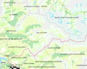
La Chapelle-en-Valgaudémar (La Chapelle-en-Valgaudémar)
- commune in Hautes-Alpes, France
 Hiking in La Chapelle-en-Valgaudémar
La Chapelle-en-Valgaudémar is a picturesque village located in the heart of the Écrins National Park in the French Alps. This area is renowned for its stunning natural beauty, rugged mountains, and a variety of hiking trails suitable for different skill levels.
Hiking Highlights:
-
Diverse Trail Options:
- Easy to Moderate Trails: There are family-friendly walking paths that offer beautiful views of the valley and surrounding mountains. Trails often lead you through charming alpine meadows and past glacial lakes.
- Challenging Hikes: For more experienced hikers, there are numerous high-altitude trails that provide a more strenuous workout along with breathtaking views of the surrounding peaks.
-
Panoramic Views:
- Many of the trails offer panoramic views of the Écrins massif, allowing hikers to appreciate the vastness of the alpine landscape. The sight of snow-capped peaks, lush forests, and clear blue skies is a common reward for your efforts.
-
Flora and Fauna:
- The region is rich in biodiversity, with various alpine flowers, wildlife, and unique ecosystems. Keep an eye out for marmots, chamois, and diverse bird species.
-
Guided Tours:
- If you prefer a structured experience, there are often guided hikes available. Local guides can provide insights into the area’s ecology, geology, and history.
-
Seasonal Considerations:
- Summer is the best time for hiking, with trails usually accessible from late June to early October. Spring and fall can be unpredictable, and winter hiking requires special gear and experience due to snow conditions.
Practical Tips:
- Gear: Ensure you have proper hiking boots, clothing suitable for changing weather conditions, and enough food and water.
- Maps and Guides: It’s advisable to have a trail map or a reliable GPS device, as some paths may not be well-marked.
- Weather Conditions: Always check the weather forecast before heading out, as conditions can change rapidly in the mountains.
- Safety: Inform someone about your hiking plans, and consider joining a group for safety on more remote trails.
Hiking in La Chapelle-en-Valgaudémar offers a blend of natural beauty, adventure, and tranquility, making it a fantastic destination for both novice and experienced hikers alike. Enjoy your trek!
- Country:

- Postal Code: 05800
- Coordinates: 44° 49' 1" N, 6° 11' 41" E


- GPS tracks (wikiloc): [Link]
- AboveSeaLevel: 1050 м m
- Area: 108.02 sq km
- Population: 101
- Wikipedia en: wiki(en)
- Wikipedia: wiki(fr)
- Wikidata storage: Wikidata: Q303151
- Wikipedia Commons Category: [Link]
- Freebase ID: [/m/03mflxj]
- Freebase ID: [/m/03mflxj]
- GeoNames ID: Alt: [3010343]
- GeoNames ID: Alt: [3010343]
- SIREN number: [210500641]
- SIREN number: [210500641]
- WOEID: [22755614]
- WOEID: [22755614]
- INSEE municipality code: 05064
- INSEE municipality code: 05064
Shares border with regions:

Valjouffrey
- commune in Isère, France
Hiking in Valjouffrey
Valjouffrey is a beautiful and lesser-known hiking destination located in the Isère department of the Auvergne-Rhône-Alpes region in France. Nestled in the heart of the Vercors Massif, Valjouffrey offers stunning landscapes characterized by dramatic peaks, lush valleys, and serene alpine lakes, making it a perfect spot for outdoor enthusiasts....
- Country:
- Postal Code: 38740
- Coordinates: 44° 52' 20" N, 6° 1' 52" E
- GPS tracks (wikiloc): [Link]
- AboveSeaLevel: 1014 м m
- Area: 72.56 sq km
- Population: 145
- Web site: [Link]

Villar-Loubière
- commune in Hautes-Alpes, France
Hiking in Villar-Loubière
Villar-Loubière is a picturesque village located in the Provence-Alpes-Côte d'Azur region of southeastern France. It’s surrounded by stunning natural landscapes, making it a great destination for hiking enthusiasts....
- Country:
- Postal Code: 05800
- Coordinates: 44° 49' 34" N, 6° 8' 44" E
- GPS tracks (wikiloc): [Link]
- Area: 22.63 sq km
- Population: 42

Vallouise
- former commune in Hautes-Alpes, France
Hiking in Vallouise
Vallouise, located in the French Alps within the Ecrins National Park, is a stunning destination for hiking enthusiasts. The area is renowned for its breathtaking mountain landscapes, diverse ecosystems, and a variety of trails suitable for all levels of hikers....
- Country:
- Postal Code: 05290
- Coordinates: 44° 50' 42" N, 6° 29' 13" E
- GPS tracks (wikiloc): [Link]
- Area: 68.58 sq km
- Population: 758

Saint-Maurice-en-Valgodemard
- commune in Hautes-Alpes, France
Hiking in Saint-Maurice-en-Valgodemard
Saint-Maurice-en-Valgodemard is a beautiful village located in the French Alps, in the Hautes-Alpes department. Known for its stunning landscapes, it serves as an excellent base for various hiking adventures. Here are some key highlights for hiking in the area:...
- Country:
- Postal Code: 05800
- Coordinates: 44° 48' 14" N, 6° 5' 44" E
- GPS tracks (wikiloc): [Link]
- Area: 36.37 sq km
- Population: 133

La Motte-en-Champsaur
- commune in Hautes-Alpes, France
Hiking in La Motte-en-Champsaur
La Motte-en-Champsaur is a charming village located in the French Alps, known for its stunning natural scenery and a variety of hiking opportunities. The region offers a mix of landscapes, including alpine meadows, dense forests, and panoramic mountain views, making it an excellent destination for both novice and experienced hikers....
- Country:
- Postal Code: 05500
- Coordinates: 44° 43' 57" N, 6° 4' 5" E
- GPS tracks (wikiloc): [Link]
- Area: 52.8 sq km
- Population: 215
- Web site: [Link]

Champoléon
- commune in Hautes-Alpes, France
Hiking in Champoléon
Champoléon is a beautiful valley located in the Écrins National Park in the French Alps, known for its stunning landscapes, diverse flora and fauna, and a variety of hiking trails suitable for different skill levels. Here are some key points to consider when hiking in Champoléon:...
- Country:
- Postal Code: 05260
- Coordinates: 44° 43' 14" N, 6° 15' 40" E
- GPS tracks (wikiloc): [Link]
- Area: 98.54 sq km
- Population: 148

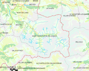
Saint-Christophe-en-Oisans
- commune in Isère, France
Hiking in Saint-Christophe-en-Oisans
Saint-Christophe-en-Oisans is a charming village located in the French Alps, nestled within the Oisans valley. It serves as a gateway to some stunning hiking opportunities in the surrounding terrain, known for its breathtaking scenery, diverse ecosystems, and the proximity to the Écrins National Park....
- Country:
- Postal Code: 38520
- Coordinates: 44° 57' 26" N, 6° 10' 37" E
- GPS tracks (wikiloc): [Link]
- Area: 123.5 sq km
- Population: 105
- Web site: [Link]