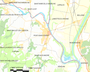
Saint-Paulet-de-Caisson (Saint-Paulet-de-Caisson)
- commune in Gard, France
- Country:

- Postal Code: 30130
- Coordinates: 44° 15' 48" N, 4° 35' 50" E


- GPS tracks (wikiloc): [Link]
- Area: 16.88 sq km
- Population: 1793
- Web site: http://www.ville-saintpauletdecaisson.fr
- Wikipedia en: wiki(en)
- Wikipedia: wiki(fr)
- Wikidata storage: Wikidata: Q268273
- Wikipedia Commons Category: [Link]
- Freebase ID: [/m/03c7zk6]
- GeoNames ID: Alt: [2977657]
- SIREN number: [213002900]
- BnF ID: [15254930m]
- VIAF ID: Alt: [167441794]
- Library of Congress authority ID: Alt: [n87819614]
- PACTOLS thesaurus ID: [pcrtxs1Mkw43Xl]
- INSEE municipality code: 30290
Shares border with regions:


Pont-Saint-Esprit
- commune in Gard, France
- Country:

- Postal Code: 30130
- Coordinates: 44° 15' 23" N, 4° 38' 54" E


- GPS tracks (wikiloc): [Link]
- AboveSeaLevel: 59 м m
- Area: 18.49 sq km
- Population: 10279
- Web site: [Link]


Carsan
- commune in Gard, France
- Country:

- Postal Code: 30130
- Coordinates: 44° 14' 16" N, 4° 35' 37" E


- GPS tracks (wikiloc): [Link]
- Area: 11.71 sq km
- Population: 646
- Web site: [Link]


Salazac
- commune in Gard, France
- Country:

- Postal Code: 30760
- Coordinates: 44° 15' 37" N, 4° 31' 31" E


- GPS tracks (wikiloc): [Link]
- Area: 9.98 sq km
- Population: 184


Saint-Michel-d'Euzet
- commune in Gard, France
- Country:

- Postal Code: 30200
- Coordinates: 44° 12' 5" N, 4° 32' 39" E


- GPS tracks (wikiloc): [Link]
- Area: 10.36 sq km
- Population: 623

Saint-Just-d'Ardèche
- commune in Ardèche, France
- Country:

- Postal Code: 07700
- Coordinates: 44° 18' 16" N, 4° 36' 40" E


- GPS tracks (wikiloc): [Link]
- AboveSeaLevel: 63 м m
- Area: 10.44 sq km
- Population: 1697


Saint-Julien-de-Peyrolas
- commune in Gard, France
- Country:

- Postal Code: 30760
- Coordinates: 44° 17' 17" N, 4° 33' 55" E


- GPS tracks (wikiloc): [Link]
- Area: 12.54 sq km
- Population: 1362
- Web site: [Link]


Saint-Laurent-de-Carnols
- commune in Gard, France
- Country:

- Postal Code: 30200
- Coordinates: 44° 12' 44" N, 4° 31' 50" E


- GPS tracks (wikiloc): [Link]
- Area: 10.15 sq km
- Population: 475
- Web site: [Link]
