Saint-Pierre-de-Trivisy (Saint-Pierre-de-Trivisy)

- commune in Tarn, France
- Country:

- Postal Code: 81330
- Coordinates: 43° 45' 40" N, 2° 26' 5" E


- GPS tracks (wikiloc): [Link]
- Area: 36.09 sq km
- Population: 630
- Web site: http://www.st-pierre-trivisy.fr
- Wikipedia en: wiki(en)
- Wikipedia: wiki(fr)
- Wikidata storage: Wikidata: Q1618987
- Wikipedia Commons Category: [Link]
- Freebase ID: [/m/03npncv]
- GeoNames ID: Alt: [6444952]
- SIREN number: [218102671]
- BnF ID: [15277573x]
- INSEE municipality code: 81267
Shares border with regions:


Montredon-Labessonnié
- commune in Tarn, France
- Country:
- Postal Code: 81360
- Coordinates: 43° 43' 13" N, 2° 19' 35" E
- GPS tracks (wikiloc): [Link]
- Area: 110.88 sq km
- Population: 2036
- Web site: [Link]


Vabre
- commune in Tarn, France
- Country:
- Postal Code: 81330
- Coordinates: 43° 41' 35" N, 2° 25' 35" E
- GPS tracks (wikiloc): [Link]
- Area: 28.43 sq km
- Population: 797
- Web site: [Link]

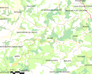
Lacaze
- commune in Tarn, France
- Country:
- Postal Code: 81330
- Coordinates: 43° 44' 18" N, 2° 31' 12" E
- GPS tracks (wikiloc): [Link]
- Area: 46.16 sq km
- Population: 294
- Web site: [Link]

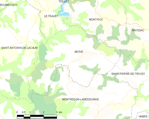
Arifat
- commune in Tarn, France
- Country:
- Postal Code: 81360
- Coordinates: 43° 47' 4" N, 2° 21' 51" E
- GPS tracks (wikiloc): [Link]
- Area: 20.28 sq km
- Population: 159
- Web site: [Link]

Rayssac
- commune in Tarn, France
- Country:
- Postal Code: 81330
- Coordinates: 43° 49' 4" N, 2° 24' 51" E
- GPS tracks (wikiloc): [Link]
- Area: 29.95 sq km
- Population: 253