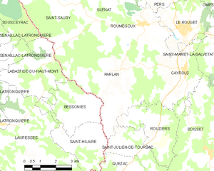
Saint-Saury (Saint-Saury)

- commune in Cantal, France
- Country:

- Postal Code: 15290
- Coordinates: 44° 52' 5" N, 2° 8' 23" E


- GPS tracks (wikiloc): [Link]
- Area: 30.11 sq km
- Population: 194
- Wikipedia en: wiki(en)
- Wikipedia: wiki(fr)
- Wikidata storage: Wikidata: Q270247
- Wikipedia Commons Category: [Link]
- Freebase ID: [/m/03mbb5p]
- GeoNames ID: Alt: [2977056]
- SIREN number: [211502141]
- BnF ID: [15248384n]
- INSEE municipality code: 15214
Shares border with regions:


Calviac
- former commune in Lot, France
- Country:
- Postal Code: 46190
- Coordinates: 44° 55' 23" N, 2° 2' 50" E
- GPS tracks (wikiloc): [Link]
- Area: 26.49 sq km
- Population: 139


Labastide-du-Haut-Mont
- commune in Lot, France
- Country:
- Postal Code: 46210
- Coordinates: 44° 50' 5" N, 2° 7' 15" E
- GPS tracks (wikiloc): [Link]
- Area: 9.85 sq km
- Population: 48


Glénat
- commune in Cantal, France
- Country:
- Postal Code: 15150
- Coordinates: 44° 54' 4" N, 2° 10' 51" E
- GPS tracks (wikiloc): [Link]
- Area: 24.27 sq km
- Population: 181


Sousceyrac
- former commune in Lot, France
- Country:
- Postal Code: 46190
- Coordinates: 44° 52' 24" N, 2° 2' 8" E
- GPS tracks (wikiloc): [Link]
- Area: 57.64 sq km
- Population: 855
Siran
- commune in Cantal, France
- Country:
- Postal Code: 15150
- Coordinates: 44° 57' 17" N, 2° 7' 40" E
- GPS tracks (wikiloc): [Link]
- Area: 50.88 sq km
- Population: 489

Parlan
- commune in Cantal, France
- Country:
- Postal Code: 15290
- Coordinates: 44° 49' 45" N, 2° 10' 21" E
- GPS tracks (wikiloc): [Link]
- Area: 24.12 sq km
- Population: 418
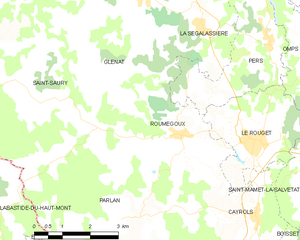
Roumégoux
- commune in Cantal, France
- Country:
- Postal Code: 15290
- Coordinates: 44° 51' 24" N, 2° 11' 55" E
- GPS tracks (wikiloc): [Link]
- Area: 13.29 sq km
- Population: 310
- Web site: [Link]