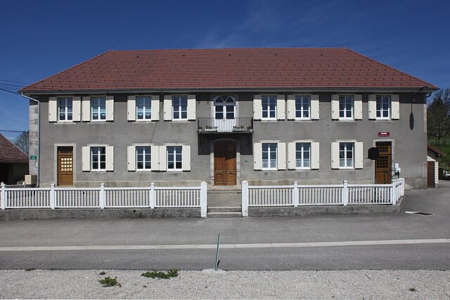
Sainte-Anne (Sainte-Anne)

- commune in Doubs, France
 Hiking in Sainte-Anne
Sainte-Anne, located in the Doubs department in eastern France, offers a range of hiking opportunities that showcase the stunning natural beauty of the Jura Mountains. The area is characterized by its picturesque landscapes, lush forests, and diverse wildlife, making it a fantastic destination for outdoor enthusiasts.
Key Features of Hiking in Sainte-Anne, Doubs:
-
Scenic Trails:
- There are various marked hiking trails ranging from easy to challenging levels, providing options for both casual walkers and experienced hikers. The trails often lead through forests, past rivers, and offer stunning views of the surrounding mountain ranges.
-
Natural Attractions:
- Hiking in this area allows you to discover notable natural features such as waterfalls, rock formations, and panoramic viewpoints that provide breathtaking vistas of the Jura landscapes.
-
Local Flora and Fauna:
- The rich biodiversity offers a chance to observe local wildlife, including various bird species, deer, and other fauna, as well as a variety of plant life, particularly in the protected areas.
-
Historical and Cultural Sites:
- Some trails might lead you to historical landmarks or cultural sites, providing insight into the region's heritage. This can enhance your hiking experience beyond just the natural beauty.
-
Seasons:
- The best time for hiking in Sainte-Anne is usually during the spring and fall when the weather is mild, and the landscapes are particularly beautiful with blossoming flowers or autumn foliage. Summer can be warmer and may have more visitors, while winter offers skiing opportunities but may not be ideal for hiking.
-
Preparation and Safety:
- As with any hiking excursion, it's essential to prepare adequately. Wear suitable footwear, bring plenty of water, and check the weather conditions. It’s also wise to carry a map or a GPS device, as some trails may not be well-marked.
-
Local Services:
- There may be local lodging options such as guesthouses or campgrounds if you’re planning to hike multiple days. Be sure to check local resources for trail maps and guided hikes if you’re unfamiliar with the area.
Whether you're looking for a peaceful day hike or a more challenging adventure, Sainte-Anne in the Doubs has something to offer for everyone. Make sure to enjoy the natural beauty and respect the environment during your hiking experience.
- Country:

- Postal Code: 25270
- Coordinates: 46° 57' 16" N, 5° 59' 7" E


- GPS tracks (wikiloc): [Link]
- Area: 6.64 sq km
- Population: 39
- Wikipedia en: wiki(en)
- Wikipedia: wiki(fr)
- Wikidata storage: Wikidata: Q569167
- Wikipedia Commons Category: [Link]
- Freebase ID: [/m/03mhcv0]
- Freebase ID: [/m/03mhcv0]
- GeoNames ID: Alt: [6453866]
- GeoNames ID: Alt: [6453866]
- SIREN number: [212505135]
- SIREN number: [212505135]
- BnF ID: [15252739p]
- BnF ID: [15252739p]
- INSEE municipality code: 25513
- INSEE municipality code: 25513
Shares border with regions:


Geraise
- commune in Jura, France
Hiking in Geraise
Geraise, while not a widely recognized hiking destination, may refer to a specific area or trail that could be known locally or under a different name. If it is meant to indicate a less popular or regional hiking area, local resources or hiking clubs can provide you with detailed trail maps, difficulty levels, and any unique features of that environment....
- Country:
- Postal Code: 39110
- Coordinates: 46° 57' 24" N, 5° 56' 54" E
- GPS tracks (wikiloc): [Link]
- Area: 6.04 sq km
- Population: 40

Dournon
- commune in Jura, France
Hiking in Dournon
Dournon, located in France, is not widely known as a major hiking destination, but it can offer some picturesque trails and scenic beauty typical of rural French landscapes. While specific trails might not be extensively documented, here are some general tips and insights you can follow when hiking in the Dournon area or similar rural locations:...
- Country:
- Postal Code: 39110
- Coordinates: 46° 55' 58" N, 5° 57' 55" E
- GPS tracks (wikiloc): [Link]
- Area: 6.55 sq km
- Population: 134


Cernans
- commune in Jura, France
Hiking in Cernans
I'm sorry, but there seems to be a misunderstanding. As of my last knowledge update in October 2023, there isn't a widely recognized hiking destination by the name "Cernans." If you meant a specific area or park that could be associated with that name, please provide more context or check the spelling....
- Country:
- Postal Code: 39110
- Coordinates: 46° 55' 55" N, 5° 55' 54" E
- GPS tracks (wikiloc): [Link]
- Area: 5.51 sq km
- Population: 140

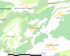
Crouzet-Migette
- commune in Doubs, France
Hiking in Crouzet-Migette
Crouzet-Migette is a beautiful area in the Jura Mountains of France, known for its stunning landscapes, diverse wildlife, and rich cultural heritage. It's less well-known than other hiking destinations in France, making it a great spot for those seeking a quieter experience in nature....
- Country:
- Postal Code: 25270
- Coordinates: 46° 57' 25" N, 6° 0' 42" E
- GPS tracks (wikiloc): [Link]
- Area: 5.67 sq km
- Population: 120

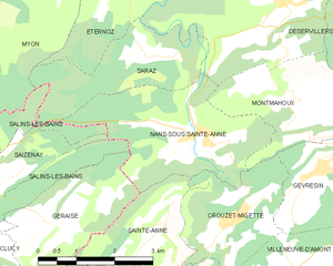
Nans-sous-Sainte-Anne
- commune in Doubs, France
Hiking in Nans-sous-Sainte-Anne
Nans-sous-Sainte-Anne is a charming village located in the Jura region of France, known for its stunning natural landscapes, rich biodiversity, and various hiking opportunities. The village is nestled within the Jura Mountains, which offer a mix of lush forests, rolling hills, rivers, and captivating rock formations....
- Country:
- Postal Code: 25330
- Coordinates: 46° 58' 36" N, 5° 59' 56" E
- GPS tracks (wikiloc): [Link]
- Area: 8.86 sq km
- Population: 139


Villeneuve-d'Amont
- commune in Doubs, France
Hiking in Villeneuve-d'Amont
Villeneuve-d'Amont is a picturesque commune located in the Jura department of France. The area is known for its beautiful landscapes and varied terrain, making it a great spot for hiking enthusiasts. Here are some key aspects to consider when planning a hike in and around Villeneuve-d'Amont:...
- Country:
- Postal Code: 25270
- Coordinates: 46° 56' 23" N, 6° 1' 55" E
- GPS tracks (wikiloc): [Link]
- Area: 14.27 sq km
- Population: 254