Saléon (Saléon)
- commune in Hautes-Alpes, France
 Hiking in Saléon
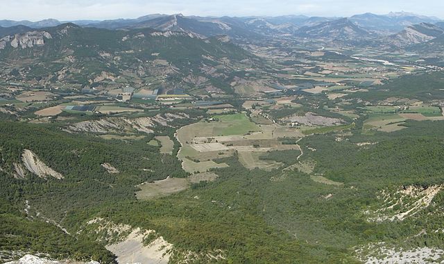
Saléon, nestled in the picturesque countryside of France, offers a range of hiking opportunities for outdoor enthusiasts. The region is characterized by its stunning landscapes, including rolling hills, verdant forests, and scenic valleys. Here are some key highlights and tips for hiking in Saléon:
Trails and Routes
-
Local Hiking Trails: Saléon has a network of marked trails that cater to various skill levels, from easy strolls to more challenging hikes. Always check local maps for trail conditions and lengths before heading out.
-
Scenic Views: Many trails provide access to panoramic viewpoints, where you can enjoy breathtaking views of the surrounding mountains and valleys.
-
Historical Sites: Some hikes may lead you to historical landmarks, such as old villages or ancient ruins, adding an element of cultural exploration to your adventure.
Flora and Fauna
- Biodiversity: The region is rich in wildlife, so keep an eye out for local fauna, including birds and small mammals. The diverse plant life also changes with the seasons, making spring and early summer particularly beautiful.
Preparation and Safety
- Gear: Suitable hiking shoes, weather-appropriate clothing, and a backpack with essentials (water, snacks, first aid kit) are crucial.
- Weather: Always check the local weather forecast before your hike, as conditions can change rapidly in the mountains.
- Maps and Navigation: Consider carrying a physical map or a GPS device, as mobile signals may be weak in some areas.
Local Regulations
- Respect Nature: Follow Leave No Trace principles to preserve the environment. Stay on marked trails, pack out what you bring in, and respect wildlife.
Enjoying Your Hike
- Take your time to enjoy the surroundings—consider bringing a camera to capture the beauty of Saléon. Whether you're an experienced hiker or a beginner, you'll find something rewarding in the trails of this charming region.
Recommendations
- Guided Tours: If you're unfamiliar with the area, consider joining a guided hiking tour to enhance your experience and learn more about the local ecology and history.
Whether you are embarking on a full-day trek or a leisurely walk, hiking in Saléon can be a delightful way to connect with nature and enjoy the serene beauty that this region has to offer.
- Country:

- Postal Code: 05300
- Coordinates: 44° 19' 55" N, 5° 46' 33" E


- GPS tracks (wikiloc): [Link]
- Area: 9.86 sq km
- Population: 91
- Wikipedia en: wiki(en)
- Wikipedia: wiki(fr)
- Wikidata storage: Wikidata: Q264865
- Wikipedia Commons Category: [Link]
- Freebase ID: [/m/03mfnwf]
- Freebase ID: [/m/03mfnwf]
- GeoNames ID: Alt: [2976476]
- GeoNames ID: Alt: [2976476]
- SIREN number: [210501599]
- SIREN number: [210501599]
- INSEE municipality code: 05159
- INSEE municipality code: 05159
Shares border with regions:

Châteauneuf-de-Chabre
- former commune in Hautes-Alpes, France
Hiking in Châteauneuf-de-Chabre
Châteauneuf-de-Chabre, located in the Hautes-Alpes region of France, is a hidden gem for outdoor enthusiasts and hikers. The area boasts stunning natural landscapes, including rugged mountains, lush valleys, and picturesque villages, making it an excellent location for both casual walkers and experienced hikers....
- Country:
- Postal Code: 05300
- Coordinates: 44° 16' 58" N, 5° 49' 10" E
- GPS tracks (wikiloc): [Link]
- Area: 23.9 sq km
- Population: 368


Eyguians
- former commune in Hautes-Alpes, France
Hiking in Eyguians
Eyguians, a charming village located in the French Alps, offers a range of hiking opportunities for outdoor enthusiasts of various skill levels. Nestled in the Hautes-Alpes department, this region is characterized by stunning mountain scenery, lush forests, and diverse wildlife....
- Country:
- Postal Code: 05300
- Coordinates: 44° 20' 47" N, 5° 46' 21" E
- GPS tracks (wikiloc): [Link]
- Area: 9.37 sq km
- Population: 229

Laragne-Montéglin
- commune in Hautes-Alpes, France
Hiking in Laragne-Montéglin
Laragne-Montéglin is a charming commune located in the Hautes-Alpes department of southeastern France. It's surrounded by stunning natural landscapes, making it a great destination for hiking enthusiasts. Here are some highlights and tips for hiking in this area:...
- Country:
- Postal Code: 05300
- Coordinates: 44° 18' 54" N, 5° 49' 18" E
- GPS tracks (wikiloc): [Link]
- Area: 23.51 sq km
- Population: 3455
- Web site: [Link]
Nossage-et-Bénévent
- commune in Hautes-Alpes, France
Hiking in Nossage-et-Bénévent
Nossage-et-Bénévent is a charming commune located in the Vosges department of France. Surrounded by natural beauty, this area offers a variety of hiking opportunities for both beginners and experienced hikers alike. Here are some highlights for hiking in and around Nossage-et-Bénévent:...
- Country:
- Postal Code: 05700
- Coordinates: 44° 18' 55" N, 5° 44' 55" E
- GPS tracks (wikiloc): [Link]
- AboveSeaLevel: 690 м m
- Area: 4.31 sq km
- Population: 14
Lagrand
- former commune in Hautes-Alpes, France
Hiking in Lagrand
Lagrand is not a widely known hiking location, so I assume you might be referring to an area such as Lagrande in the U.S. state of Oregon or possibly another place with a similar name....
- Country:
- Postal Code: 05300
- Coordinates: 44° 20' 29" N, 5° 45' 21" E
- GPS tracks (wikiloc): [Link]
- Area: 6.92 sq km
- Population: 267