San Donato di Ninea (San Donato di Ninea)
.svg)
- Italian comune
 Hiking in San Donato di Ninea
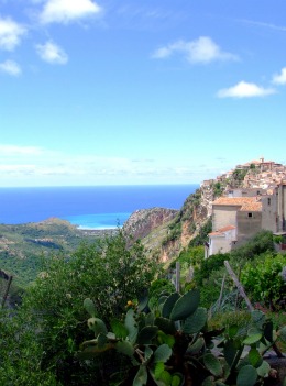
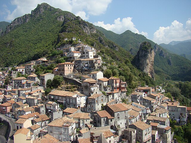
San Donato di Ninea is a picturesque town located in the Calabria region of southern Italy, known for its beautiful landscapes, rich history, and unique cultural heritage. Hiking in and around San Donato di Ninea offers a wonderful opportunity to explore the natural beauty of the area, as well as its historical sites.
Hiking Trails:
-
Sentiero della Fiumara Aco:
- This trail follows the Aco river and leads through lush forests and stunning river views. The route is accessible and suitable for families, with opportunities to discover local flora and fauna.
-
Monte Montalto:
- This hike up to Monte Montalto offers more challenging terrain and a rewarding panoramic view from the summit. The ascent can be steep at times, but the views of the surrounding mountains and valleys make it worth the effort.
-
Historical Trails:
- There are various paths that lead to historical sites within the region, including ancient ruins and old churches. Exploring these trails not only provides a physical challenge but also a glimpse into the area's rich cultural heritage.
-
Sila National Park:
- A short drive from San Donato di Ninea, this national park features extensive hiking trails through diverse ecosystems, including forests, lakes, and valleys. The trails vary in difficulty, ensuring options for both novice and experienced hikers.
Tips for Hiking in San Donato di Ninea:
- Check Weather Conditions: Weather can change quickly in mountainous regions, so always check forecasts before setting out.
- Wear Appropriate Footwear: Sturdy, waterproof hiking boots are essential for navigating trails.
- Stay Hydrated: Bring plenty of water, especially on longer hikes, as some areas may not have accessible water sources.
- Pack Snacks: Energy-boosting snacks such as nuts, fruits, and energy bars are great to have on hand.
- Respect Nature: Follow Leave No Trace principles to keep the trails and the environment pristine.
- Local Guides: Consider hiring a local guide for a more enriching experience. They can provide insights into the local ecosystem and history.
Best Time to Visit:
The best months for hiking in the region are typically spring (April to June) and autumn (September to October) when the weather is pleasant, and the landscapes are particularly beautiful. Summer can be hot, while winter may bring snow to higher elevations, affecting trail accessibility.
Enjoy your hiking adventure in San Donato di Ninea!
- Country:

- Postal Code: 87010
- Local Dialing Code: 0981
- Licence Plate Code: CS
- Coordinates: 39° 43' 0" N, 16° 2' 0" E


- GPS tracks (wikiloc): [Link]
- AboveSeaLevel: 720 м m
- Area: 82.4 sq km
- Population: 1283
- Web site: http://www.comune.sandonatodininea.cs.it/
- Wikipedia en: wiki(en)
- Wikipedia: wiki(it)
- Wikidata storage: Wikidata: Q53962
- Wikipedia Commons Category: [Link]
- Freebase ID: [/m/0f_p0x]
- GeoNames ID: Alt: [6540793]
- VIAF ID: Alt: [267845864]
- OSM relation ID: [40041]
- TGN ID: [1046496]
- ISTAT ID: 078115
- Italian cadastre code: H825
Shares border with regions:
Acquaformosa
- Italian comune
Hiking in Acquaformosa
Acquaformosa is a small village located in Calabria, Italy, and is known for its stunning natural landscape, historical architecture, and warm community spirit. Hiking in and around Acquaformosa offers a variety of experiences suitable for different skill levels, with opportunities to explore scenic trails, lush forests, and panoramic views of the surrounding mountains and valleys....
- Country:
- Postal Code: 87010
- Local Dialing Code: 0981
- Licence Plate Code: CS
- Coordinates: 39° 43' 0" N, 16° 6' 0" E
- GPS tracks (wikiloc): [Link]
- AboveSeaLevel: 756 м m
- Area: 22.71 sq km
- Population: 1108
- Web site: [Link]


Altomonte
- Italian comune
Hiking in Altomonte
Altomonte, located in the Calabria region of southern Italy, is a charming town surrounded by beautiful landscapes that are ideal for hiking enthusiasts. The area offers a blend of scenic countryside, natural beauty, and historical features that makes it a unique destination for outdoor activities. Here are some highlights of hiking in and around Altomonte:...
- Country:
- Postal Code: 87042
- Local Dialing Code: 0981
- Licence Plate Code: CS
- Coordinates: 39° 42' 0" N, 16° 8' 0" E
- GPS tracks (wikiloc): [Link]
- AboveSeaLevel: 455 м m
- Area: 65.72 sq km
- Population: 4382
- Web site: [Link]

Grisolia
- Italian comune
Hiking in Grisolia
Grisolia is a beautiful location situated in the Calabria region of Italy, known for its stunning coastal views and mountainous terrain. Hiking in and around Grisolia offers a range of experiences suitable for various skill levels, with the opportunity to explore both nature and charming local culture....
- Country:
- Postal Code: 87020
- Local Dialing Code: 0985
- Licence Plate Code: CS
- Coordinates: 39° 43' 0" N, 15° 51' 0" E
- GPS tracks (wikiloc): [Link]
- AboveSeaLevel: 480 м m
- Area: 51.75 sq km
- Population: 2223
- Web site: [Link]


Lungro
- Italian comune
Hiking in Lungro
Lungro is a charming town located in the Calabria region of southern Italy, known for its beautiful landscapes and rich cultural heritage. Hiking in and around Lungro offers a variety of trails that cater to different skill levels, allowing you to experience the stunning natural scenery of the Sila National Park and the surrounding areas....
- Country:
- Postal Code: 87010
- Local Dialing Code: 0981
- Licence Plate Code: CS
- Coordinates: 39° 45' 0" N, 16° 7' 0" E
- GPS tracks (wikiloc): [Link]
- AboveSeaLevel: 650 м m
- Area: 35.65 sq km
- Population: 2504
- Web site: [Link]

Orsomarso
- Italian comune
Hiking in Orsomarso
Orsomarso, located in the Calabria region of Italy, is a beautiful destination for hiking enthusiasts. Nestled in the heart of the Pollino National Park, it offers stunning landscapes, diverse flora, and fauna, as well as a variety of hiking trails suitable for different skill levels....
- Country:
- Postal Code: 87020
- Local Dialing Code: 0985
- Licence Plate Code: CS
- Coordinates: 39° 48' 0" N, 15° 55' 0" E
- GPS tracks (wikiloc): [Link]
- AboveSeaLevel: 120 м m
- Area: 90.41 sq km
- Population: 1243
- Web site: [Link]
San Sosti
- Italian comune
Hiking in San Sosti
San Sosti is a charming village located in the Calabria region of southern Italy, nestled in the foothills of the Pollino National Park. This area is characterized by its stunning natural landscapes, rich biodiversity, and scenic hiking routes, making it a great destination for outdoor enthusiasts....
- Country:
- Postal Code: 87010
- Local Dialing Code: 0981
- Licence Plate Code: CS
- Coordinates: 39° 40' 0" N, 16° 2' 0" E
- GPS tracks (wikiloc): [Link]
- AboveSeaLevel: 355 м m
- Area: 43.55 sq km
- Population: 2169
- Web site: [Link]

Verbicaro
- Italian comune
Hiking in Verbicaro
Verbicaro is a charming village in Calabria, Italy, nestled in the Pollino National Park region. It offers picturesque landscapes, rich culture, and various hiking opportunities that cater to different skill levels. Here are some highlights and tips for hiking in and around Verbicaro:...
- Country:
- Postal Code: 87020
- Local Dialing Code: 0985
- Licence Plate Code: CS
- Coordinates: 39° 45' 0" N, 15° 55' 0" E
- GPS tracks (wikiloc): [Link]
- AboveSeaLevel: 420 м m
- Area: 32.64 sq km
- Population: 2948
- Web site: [Link]