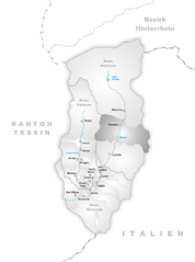
San Giacomo Filippo (San Giacomo Filippo)
.svg)
- Italian comune
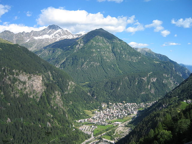
 Hiking in San Giacomo Filippo
San Giacomo Filippo, located in the Sondrio province of Lombardy, Italy, offers a variety of hiking opportunities amidst stunning landscapes of the Valtellina Valley. The region is characterized by its mountainous terrain, charming villages, lush forests, and impressive views of the surrounding Alps.
Hiking Trails and Experiences:
-
Sentiero del Viandante: This is part of a long-distance route that runs along the eastern shore of Lake Como, allowing you to experience scenic views of the lake and mountains. While it may not start directly in San Giacomo Filippo, you can connect to sections of this trail.
-
Nature Pathways: The area features several well-marked trails that allow you to explore lush forests, alpine meadows, and local wildlife. These paths are suitable for both beginner and experienced hikers.
-
Cima di Moriana: A popular destination for more seasoned hikers, this peak offers a challenging ascent with rewarding views of the surrounding valley and peaks once you reach the summit.
-
Local Flora and Fauna: As you hike, take the time to appreciate the rich biodiversity of the region, including various plant species and possibly spotting local wildlife such as chamois or eagles.
-
Cultural Insights: The hikes around San Giacomo Filippo often lead you through small villages where you can experience local culture, traditions, and cuisine. Don’t miss the opportunity to enjoy local dishes at mountain huts or restaurants.
Hiking Tips:
-
Seasonal Considerations: The best time for hiking in this area is typically from late spring to early autumn when the weather is milder and trails are accessible. Winter hikes are possible but require specific gear and skills.
-
Gear and Preparation: Ensure you have appropriate hiking gear, including sturdy boots, weather-appropriate clothing, and enough water and snacks. A map or GPS can be invaluable, as some trails may not be well-marked.
-
Local Guides: If you're unfamiliar with the area, consider hiring a local guide who can provide insights into the best routes and ensure your safety.
-
Trail Etiquette: Be mindful of nature and follow Leave No Trace principles. Stay on marked trails to protect the local ecosystem.
San Giacomo Filippo is a hidden gem for hiking enthusiasts, offering an opportunity to explore the beauty of Northern Italy's landscapes while enjoying physical activity. Whether you're looking for a leisurely walk or a strenuous hike, this region has something to offer everyone.
- Country:

- Postal Code: 23020
- Local Dialing Code: 0343
- Licence Plate Code: SO
- Coordinates: 46° 20' 0" N, 9° 22' 0" E


- GPS tracks (wikiloc): [Link]
- AboveSeaLevel: 679 м m
- Area: 61.85 sq km
- Population: 349
- Web site: http://www.comune.sangiacomofilippo.so.it/
- Wikipedia en: wiki(en)
- Wikipedia: wiki(it)
- Wikidata storage: Wikidata: Q39312
- Wikipedia Commons Gallery: [Link]
- Wikipedia Commons Category: [Link]
- Freebase ID: [/m/0gj3pn]
- GeoNames ID: Alt: [6543122]
- VIAF ID: Alt: [236108190]
- OSM relation ID: [47120]
- ISTAT ID: 014058
- Italian cadastre code: H868
Shares border with regions:

Campodolcino
- Italian comune
Hiking in Campodolcino
Campodolcino is a picturesque village located in the province of Sondrio in the Lombardy region of Italy, nestled in the heart of the Italian Alps. This area is not only known for its stunning landscapes but also for the variety of hiking opportunities it offers, catering to all levels of outdoor enthusiasts....
- Country:
- Postal Code: 23021
- Local Dialing Code: 0343
- Licence Plate Code: SO
- Coordinates: 46° 24' 18" N, 9° 21' 11" E
- GPS tracks (wikiloc): [Link]
- AboveSeaLevel: 1071 м m
- Area: 48.49 sq km
- Population: 931
- Web site: [Link]
Piuro
- Italian comune
Hiking in Piuro
Piuro is a picturesque village located in the Lombardy region of northern Italy, nestled in the Seriana Valley and close to the border with Switzerland. The area is known for its stunning natural beauty, making it a great destination for hiking enthusiasts. Here are some highlights about hiking in Piuro:...
- Country:
- Postal Code: 23020
- Local Dialing Code: 0343
- Licence Plate Code: SO
- Coordinates: 46° 19' 51" N, 9° 25' 18" E
- GPS tracks (wikiloc): [Link]
- AboveSeaLevel: 382 м m
- Area: 84.25 sq km
- Population: 1932
- Web site: [Link]
Mese
- Italian comune
Hiking in Mese
Mese, located in the province of Sondrio in the Lombardy region of Northern Italy, is a fantastic area for hiking enthusiasts. Nestled in the heart of the Valtellina Valley and surrounded by the stunning backdrop of the Alps, Mese offers a variety of hiking trails suitable for different skill levels....
- Country:
- Postal Code: 23020
- Local Dialing Code: 0343
- Licence Plate Code: SO
- Coordinates: 46° 18' 0" N, 9° 23' 0" E
- GPS tracks (wikiloc): [Link]
- AboveSeaLevel: 274 м m
- Area: 4.15 sq km
- Population: 1814
- Web site: [Link]


Chiavenna
- Italian comune
Hiking in Chiavenna
Chiavenna, located in the Lombardy region of northern Italy, is an excellent destination for hiking due to its stunning natural landscapes and rich cultural history. Nestled at the entrance of the Val Bregaglia and near the borders of Switzerland, this charming town serves as a base for numerous hiking trails that cater to various skill levels....
- Country:
- Postal Code: 23022
- Local Dialing Code: 0343
- Licence Plate Code: SO
- Coordinates: 46° 19' 0" N, 9° 24' 0" E
- GPS tracks (wikiloc): [Link]
- AboveSeaLevel: 333 м m
- Area: 10.77 sq km
- Population: 7313
- Web site: [Link]


Mesocco
- municipality in Switzerland
Hiking in Mesocco
Mesocco, located in the picturesque Mendrisiotto region of southern Switzerland, offers a variety of hiking opportunities that cater to different skill levels and interests. Nestled in the valley of the Moesa River, this charming area is known for its stunning landscapes, historic villages, and lush nature....
- Country:

- Postal Code: 6563
- Local Dialing Code: 091
- Licence Plate Code: GR
- Coordinates: 46° 23' 29" N, 9° 14' 15" E
- GPS tracks (wikiloc): [Link]
- AboveSeaLevel: 828 м m
- Area: 164.9 sq km
- Population: 1374
- Web site: [Link]

Soazza
- municipality in Switzerland
Hiking in Soazza
Soazza is a charming village located in the Ticino region of Switzerland, surrounded by stunning natural landscapes that make it an excellent destination for hiking enthusiasts. Nestled in the mountains, Soazza offers a variety of trails suitable for all skill levels, from easy walks to more challenging hikes....
- Country:
- Postal Code: 6562
- Local Dialing Code: 091
- Licence Plate Code: GR
- Coordinates: 46° 20' 59" N, 9° 12' 59" E
- GPS tracks (wikiloc): [Link]
- AboveSeaLevel: 620 м m
- Area: 46.42 sq km
- Population: 337
- Web site: [Link]