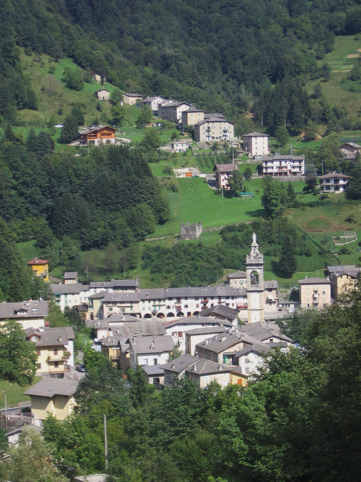
Santa Brigida (Santa Brigida)
.svg)
- Italian comune in Lombardy
 Hiking in Santa Brigida
Santa Brigida, located in the Lombardy region of northern Italy, is a wonderful destination for hiking enthusiasts. It is nestled in the Bergamo Alps, providing stunning landscapes, rich flora and fauna, and various trail options for different skill levels.
Hiking Trails:
-
Valle di Santa Brigida: A scenic valley that offers several hiking paths. The trails meander through lush forests and past picturesque streams. It's perfect for those looking for a peaceful hike.
-
Sentiero dei Ghiacciai: This trail takes you through areas historically impacted by glaciers. You'll get to witness unique geological formations and possibly spot local wildlife.
-
Monte Verta: A popular hike that is moderately challenging, leading you to one of the local peaks. From the top, you can enjoy panoramic views of the surrounding mountains and valleys.
-
Cascate del Serio: Although slightly farther from Santa Brigida, the famous waterfalls are worth the trip. The hike around the area offers vibrant vegetation and stunning views.
Best Time to Hike:
The best time for hiking in Santa Brigida is from late spring to early fall (May to September). The weather is typically mild, and the trails are more accessible. However, always check local weather conditions before heading out, as mountain weather can change rapidly.
Tips for Hiking in Santa Brigida:
- Gear Up Properly: Good hiking boots, weather-appropriate clothing, and a backpack with water and snacks are essential.
- Stay on Marked Trails: While exploring is part of the adventure, staying on marked trails helps preserve the natural environment.
- Respect Wildlife: Be mindful of the local wildlife; do not disturb animals and maintain a safe distance.
- Plan Ahead: Make sure to inform someone of your hiking plans and expected return time.
Local Amenities:
Santa Brigida has a few local accommodations and eateries where you can enjoy traditional Lombard cuisine. Be sure to try local specialties after a day of hiking!
Overall, Santa Brigida offers a rich hiking experience with its natural beauty, well-marked trails, and the opportunity to immerse yourself in the stunning landscapes of the Bergamo Alps. Enjoy your hike!
- Country:

- Postal Code: 24010
- Local Dialing Code: 0345
- Licence Plate Code: BG
- Coordinates: 45° 59' 0" N, 9° 37' 0" E


- GPS tracks (wikiloc): [Link]
- AboveSeaLevel: 805 м m
- Area: 13.8 sq km
- Population: 549
- Web site: http://www.comune.santabrigida.bg.it
- Wikipedia en: wiki(en)
- Wikipedia: wiki(it)
- Wikidata storage: Wikidata: Q101557
- Wikipedia Commons Gallery: [Link]
- Wikipedia Commons Category: [Link]
- Freebase ID: [/m/0gjdn2]
- GeoNames ID: Alt: [6536157]
- OSM relation ID: [46653]
- ISTAT ID: 016191
- Italian cadastre code: I168
- LombardiaBeniCulturali toponym ID: 1000447
Shares border with regions:


Cassiglio
- Italian comune
Hiking in Cassiglio
Cassiglio is a picturesque village located in the province of Bergamo, in the Lombardy region of Italy. It lies in the heart of the Italian Alps, making it a fantastic destination for hiking enthusiasts. Here are some key points about hiking in and around Cassiglio:...
- Country:
- Postal Code: 24010
- Local Dialing Code: 0345
- Licence Plate Code: BG
- Coordinates: 45° 58' 0" N, 9° 36' 44" E
- GPS tracks (wikiloc): [Link]
- AboveSeaLevel: 602 м m
- Area: 13.68 sq km
- Population: 110
- Web site: [Link]


Cusio, Lombardy
- Italian comune
Hiking in Cusio, Lombardy
Cusio, located in the Lombardy region of Italy, is a picturesque area known for its stunning landscapes, including parts of Lake Orta and the surrounding mountains. This region offers a variety of hiking opportunities that cater to different skill levels, from leisurely walks along the shores of the lake to more challenging mountain trails....
- Country:
- Postal Code: 24010
- Local Dialing Code: 0345
- Licence Plate Code: BG
- Coordinates: 45° 59' 27" N, 9° 36' 9" E
- GPS tracks (wikiloc): [Link]
- AboveSeaLevel: 1050 м m
- Area: 9.41 sq km
- Population: 278
- Web site: [Link]


Olmo al Brembo
- Italian comune
Hiking in Olmo al Brembo
Olmo al Brembo is a charming village located in the Lombardy region of Italy, nestled in the scenic Brembana Valley. It's surrounded by stunning natural landscapes, making it a fantastic destination for hiking enthusiasts. Here are some highlights and tips for hiking in and around Olmo al Brembo:...
- Country:
- Postal Code: 24010
- Local Dialing Code: 0345
- Licence Plate Code: BG
- Coordinates: 45° 58' 20" N, 9° 38' 57" E
- GPS tracks (wikiloc): [Link]
- AboveSeaLevel: 556 м m
- Area: 7.9 sq km
- Population: 500
- Web site: [Link]
Gerola Alta
- Italian comune
Hiking in Gerola Alta
Gerola Alta is a beautiful destination for hiking enthusiasts, located in the Lombardy region of Italy, specifically in the province of Sondrio. Known for its stunning mountain scenery, this area offers a variety of trails that cater to different skill levels, making it suitable for both novice and experienced hikers....
- Country:
- Postal Code: 23010
- Local Dialing Code: 0342
- Licence Plate Code: SO
- Coordinates: 46° 4' 0" N, 9° 34' 0" E
- GPS tracks (wikiloc): [Link]
- AboveSeaLevel: 1050 м m
- Area: 37.43 sq km
- Population: 174
- Web site: [Link]

Averara
- Italian comune
Hiking in Averara
Averara is a beautiful destination for hiking enthusiasts, nestled in the Bergamo Alps in the Lombardy region of Italy. This picturesque village offers a range of hiking trails suitable for various skill levels, set against the backdrop of stunning mountain scenery, lush forests, and vibrant flora....
- Country:
- Postal Code: 24010
- Local Dialing Code: 0345
- Licence Plate Code: BG
- Coordinates: 45° 59' 20" N, 9° 37' 53" E
- GPS tracks (wikiloc): [Link]
- AboveSeaLevel: 650 м m
- Area: 10.69 sq km
- Population: 178
- Web site: [Link]