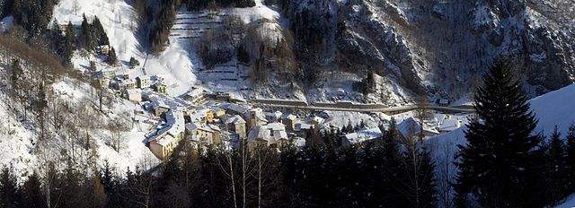
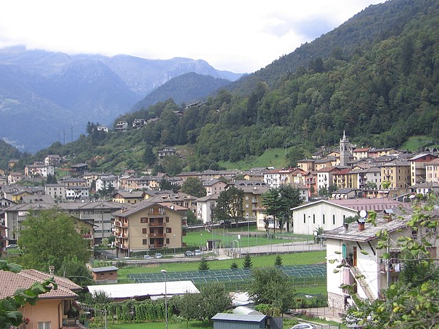
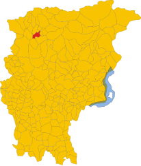
Cassiglio (Cassiglio)
.svg)
- Italian comune
 Hiking in Cassiglio
Cassiglio is a picturesque village located in the province of Bergamo, in the Lombardy region of Italy. It lies in the heart of the Italian Alps, making it a fantastic destination for hiking enthusiasts. Here are some key points about hiking in and around Cassiglio:
Scenic Trails
- Variety of Trails: The area offers various hiking trails that cater to all skill levels, from easy walks suitable for families to more challenging hikes for experienced trekkers.
- Panoramic Views: Many trails provide stunning views of the surrounding mountains, valleys, and lakes, particularly the nearby Lake of Pusiano and the majestic Orobie Alps.
Popular Hiking Routes
- Sentiero dei Fiori: This is a well-known trail that showcases a rich variety of flora and offers beautiful vistas, making it ideal for nature lovers.
- Cima di Piazzola: For a more challenging trek, hikers can reach the summit of this peak, which is rewarded with breathtaking views of the Orobie range.
- Local Historical Trails: Some routes take you through historical sites and old paths, allowing hikers to experience the rich cultural heritage of the area.
Wildlife and Nature
- Biodiversity: The area is home to diverse wildlife, including various bird species, deer, and other native animals. Early morning hikes can be particularly rewarding for wildlife spotting.
- Flora: Depending on the season, you can observe a wide range of plant life, from alpine flowers to lush forests.
Practical Tips
- Best Time to Hike: The best months for hiking in Cassiglio are typically from late spring to early fall (May to September) when the weather is mild and the trails are accessible.
- Gear: Depending on the season and the trail's difficulty, appropriate hiking gear, including sturdy boots, weather-appropriate clothing, and plenty of water, are essential.
- Maps and Guides: It is advisable to carry a map or use a hiking app to navigate the trails and to check for any local guidelines or trail conditions.
Local Amenities
- Accommodations: There are various options for staying in Cassiglio, from hotels to guesthouses, which can provide a cozy base for your hiking adventures.
- Cafes and Restaurants: After a long day of hiking, you can find local eateries serving traditional Lombard cuisine where you can refuel.
Conclusion
Hiking in Cassiglio offers an excellent opportunity to immerse yourself in nature, enjoy beautiful landscapes, and experience the rich culture of the Lombardy region. Whether you're an avid hiker or a casual walker, this area has much to offer.
- Country:

- Postal Code: 24010
- Local Dialing Code: 0345
- Licence Plate Code: BG
- Coordinates: 45° 58' 0" N, 9° 36' 44" E


- GPS tracks (wikiloc): [Link]
- AboveSeaLevel: 602 м m
- Area: 13.68 sq km
- Population: 110
- Web site: http://www.comune.cassiglio.bg.it/
- Wikipedia en: wiki(en)
- Wikipedia: wiki(it)
- Wikidata storage: Wikidata: Q100162
- Wikipedia Commons Gallery: [Link]
- Wikipedia Commons Category: [Link]
- Freebase ID: [/m/0gj9cx]
- GeoNames ID: Alt: [6539489]
- OSM relation ID: [46550]
- ISTAT ID: 016061
- Italian cadastre code: C007
Shares border with regions:


Camerata Cornello
- Italian comune
Hiking in Camerata Cornello
Camerata Cornello is a picturesque village located in the Italian Alps, specifically in the Lombardy region, within the province of Bergamo. It offers a variety of hiking opportunities with stunning natural landscapes, historical sites, and charming alpine scenery....
- Country:
- Postal Code: 24010
- Local Dialing Code: 0345
- Licence Plate Code: BG
- Coordinates: 45° 54' 0" N, 9° 39' 0" E
- GPS tracks (wikiloc): [Link]
- AboveSeaLevel: 570 м m
- Area: 12.94 sq km
- Population: 616
- Web site: [Link]


Cusio, Lombardy
- Italian comune
Hiking in Cusio, Lombardy
Cusio, located in the Lombardy region of Italy, is a picturesque area known for its stunning landscapes, including parts of Lake Orta and the surrounding mountains. This region offers a variety of hiking opportunities that cater to different skill levels, from leisurely walks along the shores of the lake to more challenging mountain trails....
- Country:
- Postal Code: 24010
- Local Dialing Code: 0345
- Licence Plate Code: BG
- Coordinates: 45° 59' 27" N, 9° 36' 9" E
- GPS tracks (wikiloc): [Link]
- AboveSeaLevel: 1050 м m
- Area: 9.41 sq km
- Population: 278
- Web site: [Link]


Olmo al Brembo
- Italian comune
Hiking in Olmo al Brembo
Olmo al Brembo is a charming village located in the Lombardy region of Italy, nestled in the scenic Brembana Valley. It's surrounded by stunning natural landscapes, making it a fantastic destination for hiking enthusiasts. Here are some highlights and tips for hiking in and around Olmo al Brembo:...
- Country:
- Postal Code: 24010
- Local Dialing Code: 0345
- Licence Plate Code: BG
- Coordinates: 45° 58' 20" N, 9° 38' 57" E
- GPS tracks (wikiloc): [Link]
- AboveSeaLevel: 556 м m
- Area: 7.9 sq km
- Population: 500
- Web site: [Link]

Ornica
- Italian comune
Hiking in Ornica
Ornica is a small village in the Lombardy region of northern Italy, situated in the Bergamasque Alps. It offers a beautiful natural setting for hikers and outdoor enthusiasts. Here are some highlights and important information regarding hiking in Ornica:...
- Country:
- Postal Code: 24010
- Local Dialing Code: 0345
- Licence Plate Code: BG
- Coordinates: 45° 59' 18" N, 9° 34' 45" E
- GPS tracks (wikiloc): [Link]
- AboveSeaLevel: 922 м m
- Area: 15.1 sq km
- Population: 152
- Web site: [Link]
Piazza Brembana
- Italian comune
Hiking in Piazza Brembana
Piazza Brembana is a picturesque valley located in the Bergamo province of Lombardy, Italy. It's surrounded by the stunning Orobie Alps, making it an excellent destination for hiking enthusiasts. The area boasts a variety of trails, ranging from easy walks suitable for families to challenging hikes for more experienced trekkers....
- Country:
- Postal Code: 24014
- Local Dialing Code: 0345
- Licence Plate Code: BG
- Coordinates: 45° 56' 50" N, 9° 40' 30" E
- GPS tracks (wikiloc): [Link]
- AboveSeaLevel: 518 м m
- Area: 6.77 sq km
- Population: 1213
- Web site: [Link]


Santa Brigida
- Italian comune in Lombardy
Hiking in Santa Brigida
Santa Brigida, located in the Lombardy region of northern Italy, is a wonderful destination for hiking enthusiasts. It is nestled in the Bergamo Alps, providing stunning landscapes, rich flora and fauna, and various trail options for different skill levels....
- Country:
- Postal Code: 24010
- Local Dialing Code: 0345
- Licence Plate Code: BG
- Coordinates: 45° 59' 0" N, 9° 37' 0" E
- GPS tracks (wikiloc): [Link]
- AboveSeaLevel: 805 м m
- Area: 13.8 sq km
- Population: 549
- Web site: [Link]


Taleggio, Lombardy
- Italian comune
Hiking in Taleggio, Lombardy
Taleggio is a picturesque valley located in the Bergamo province of Lombardy, Italy. It is renowned for its stunning landscapes, rich history, and traditional agriculture, including the famous Taleggio cheese. Hiking in this region offers a variety of trails, ranging from easy walks to more challenging routes, catering to different skill levels. Here are some highlights and tips for hiking in Taleggio:...
- Country:
- Postal Code: 24010
- Local Dialing Code: 0345
- Licence Plate Code: BG
- Coordinates: 45° 54' 0" N, 9° 34' 0" E
- GPS tracks (wikiloc): [Link]
- AboveSeaLevel: 758 м m
- Area: 46.59 sq km
- Population: 552
- Web site: [Link]


Valtorta, Lombardy
- Italian comune
Hiking in Valtorta, Lombardy
Valtorta is a beautiful area in Lombardy, Italy, particularly popular for hiking enthusiasts looking for stunning alpine landscapes. Nestled in the Bergamasque Alps, Valtorta offers a variety of trails that range in difficulty, making it a suitable destination for both beginners and experienced hikers....
- Country:
- Postal Code: 24010
- Local Dialing Code: 0345
- Licence Plate Code: BG
- Coordinates: 45° 58' 39" N, 9° 32' 5" E
- GPS tracks (wikiloc): [Link]
- AboveSeaLevel: 935 м m
- Area: 30.9 sq km
- Population: 270
- Web site: [Link]


Vedeseta
- Italian comune
Hiking in Vedeseta
Vedeseta is a picturesque village located in the province of Bergamo in Lombardy, Italy, known for its stunning natural landscapes and hiking opportunities. The area is surrounded by the Italian Alps and offers various trails suitable for different skill levels, making it an attractive destination for hikers....
- Country:
- Postal Code: 24010
- Local Dialing Code: 0345
- Licence Plate Code: BG
- Coordinates: 45° 53' 27" N, 9° 32' 23" E
- GPS tracks (wikiloc): [Link]
- AboveSeaLevel: 820 м m
- Area: 19.29 sq km
- Population: 205
- Web site: [Link]