Savignac-Mona (Savignac-Mona)

- commune in Gers, France
- Country:

- Postal Code: 32130
- Coordinates: 43° 29' 21" N, 1° 0' 28" E


- GPS tracks (wikiloc): [Link]
- Area: 6.87 sq km
- Population: 138
- Wikipedia en: wiki(en)
- Wikipedia: wiki(fr)
- Wikidata storage: Wikidata: Q739147
- Wikipedia Commons Category: [Link]
- Freebase ID: [/m/03nrv1z]
- GeoNames ID: Alt: [6432129]
- SIREN number: [213204217]
- BnF ID: [152560073]
- INSEE municipality code: 32421
Shares border with regions:


Pébées
- commune in Gers, France
- Country:
- Postal Code: 32130
- Coordinates: 43° 27' 35" N, 1° 1' 34" E
- GPS tracks (wikiloc): [Link]
- Area: 4.05 sq km
- Population: 96


Seysses-Savès
- commune in Gers, France
- Country:
- Postal Code: 32130
- Coordinates: 43° 30' 23" N, 1° 2' 29" E
- GPS tracks (wikiloc): [Link]
- Area: 13.26 sq km
- Population: 245
- Web site: [Link]


Monblanc
- commune in Gers, France
- Country:
- Postal Code: 32130
- Coordinates: 43° 27' 50" N, 0° 59' 25" E
- GPS tracks (wikiloc): [Link]
- Area: 12.93 sq km
- Population: 352
Nizas
- commune in Gers, France
- Country:
- Postal Code: 32130
- Coordinates: 43° 29' 53" N, 0° 59' 57" E
- GPS tracks (wikiloc): [Link]
- Area: 4.16 sq km
- Population: 156

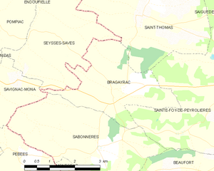
Bragayrac
- commune in Haute-Garonne, France
- Country:
- Postal Code: 31470
- Coordinates: 43° 28' 55" N, 1° 4' 11" E
- GPS tracks (wikiloc): [Link]
- Area: 8.25 sq km
- Population: 322
- Web site: [Link]

Sabonnères
- commune in Haute-Garonne, France
- Country:
- Postal Code: 31370
- Coordinates: 43° 27' 58" N, 1° 3' 50" E
- GPS tracks (wikiloc): [Link]
- Area: 12.3 sq km
- Population: 310
- Web site: [Link]