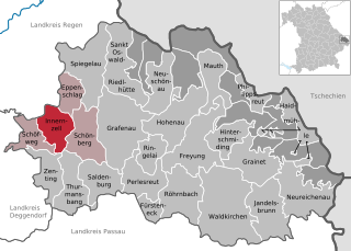
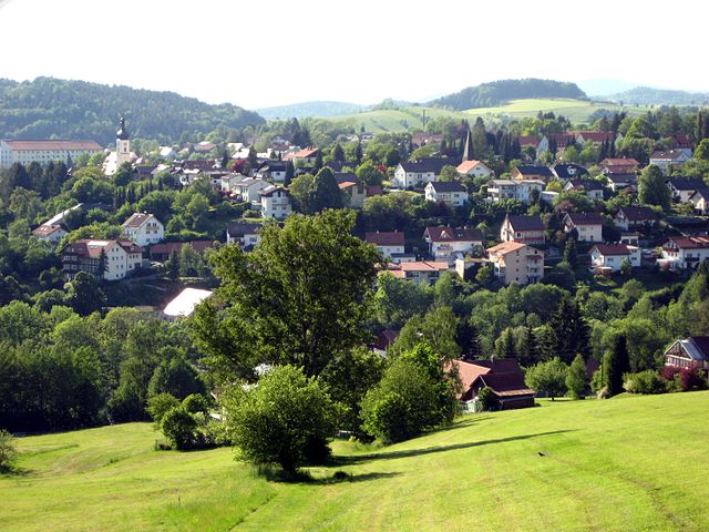
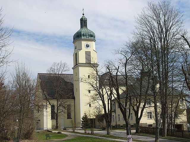
Schönberg (Schönberg)

- municipality in the district of Freyung-Grafenau in Bavaria in Germany
 Hiking in Schönberg
Schönberg, located in Lower Bavaria, is a picturesque area known for its stunning natural landscapes and hiking opportunities. Here are some key features of hiking in this region:
Trail Variety
- Scenic Routes: The area around Schönberg offers a variety of hiking trails that cater to different skill levels, from easy walks suitable for families to more challenging hikes for experienced trekkers.
- Nature Reserves: Many trails pass through beautiful nature reserves, offering opportunities to see local wildlife and diverse flora.
Popular Trails
- Schönberg to the Dreisessel Mountain: This is a popular hiking route that combines great views with a moderate level of challenge. The Dreisessel itself is a noteworthy peak offering panoramic views of the surrounding landscape.
- Rundweg Schönberg: A circular trail that allows hikers to explore the surrounding forests and meadows, typically taking about 2-3 hours to complete.
Scenic Views
- The region is characterized by rolling hills, lush forests, and serene rivers, providing numerous vantage points for breathtaking views, especially during sunset or sunrise.
Local Attractions
- Cultural Sites: Along the hiking routes, you might encounter charming Bavarian villages, historical churches, and traditional farms, adding a cultural aspect to your hike.
- Bavarian Cuisine: Don’t forget to try local cuisine in the nearby villages, as many offer hearty meals that are perfect after a day of hiking.
Tips for Hiking in Schönberg
- Weather: Always check the weather before heading out, as conditions can change rapidly in mountainous areas.
- Gear: Wear proper hiking footwear and consider bringing trekking poles for more challenging trails.
- Maps and Signage: Most trails are well-marked, but it's a good idea to carry a map or download a hiking app for offline use.
- Hydration and Snacks: Carry sufficient water and some snacks, particularly for longer hikes.
Overall, Schönberg, Lower Bavaria, is an excellent destination for outdoor enthusiasts looking to enjoy the beauty of nature combined with the charm of Bavarian culture. Happy hiking!
- Country:

- Postal Code: 94513
- Local Dialing Code: 08554
- Licence Plate Code: FRG
- Coordinates: 48° 50' 0" N, 13° 20' 0" E


- GPS tracks (wikiloc): [Link]
- AboveSeaLevel: 563 м m
- Area: 32.75 sq km
- Population: 3663
- Web site: http://www.markt-schoenberg.de
- Wikipedia en: wiki(en)
- Wikipedia: wiki(de)
- Wikidata storage: Wikidata: Q255041
- Wikipedia Commons Category: [Link]
- Freebase ID: [/m/02q373s]
- GeoNames ID: Alt: [2836963]
- OSM relation ID: [958960]
- GND ID: Alt: [4385688-3]
- Bavarikon ID: [ODB_A00001479]
- German municipality key: 09272147
Shares border with regions:


Eppenschlag
- municipality of Germany
Hiking in Eppenschlag
Eppenschlag is a charming town located in the Bavaria region of Germany, surrounded by beautiful landscapes that offer a variety of hiking opportunities. Here are some highlights and tips for hiking in and around Eppenschlag:...
- Country:
- Postal Code: 94536
- Local Dialing Code: 09928
- Licence Plate Code: FRG
- Coordinates: 48° 53' 0" N, 13° 18' 0" E
- GPS tracks (wikiloc): [Link]
- AboveSeaLevel: 608 м m
- Area: 17.03 sq km
- Population: 890
- Web site: [Link]


Thurmansbang
- municipality of Germany
Hiking in Thurmansbang
Thurmansbang is a picturesque village located in Bavaria, Germany, surrounded by the beautiful landscape of the Bavarian Forest. It's an excellent destination for hiking enthusiasts, offering a variety of trails that cater to different skill levels and preferences....
- Country:
- Postal Code: 94169
- Local Dialing Code: 08504
- Licence Plate Code: FRG
- Coordinates: 48° 46' 0" N, 13° 19' 0" E
- GPS tracks (wikiloc): [Link]
- AboveSeaLevel: 494 м m
- Area: 32.93 sq km
- Population: 2159
- Web site: [Link]


Saldenburg
- municipality of Germany
Hiking in Saldenburg
Saldenburg, located in Bavaria, Germany, is a charming area that offers a variety of hiking opportunities amidst beautiful natural landscapes. Known for its picturesque countryside, forests, and hills, Saldenburg is an excellent destination for hikers of all levels....
- Country:
- Postal Code: 94163
- Local Dialing Code: 08504
- Licence Plate Code: FRG
- Coordinates: 48° 47' 0" N, 13° 21' 0" E
- GPS tracks (wikiloc): [Link]
- AboveSeaLevel: 532 м m
- Area: 28.04 sq km
- Population: 1982
- Web site: [Link]

Innernzell
- municipality of Germany
Hiking in Innernzell
Innernzell is a charming village located in Bavaria, Germany, known for its beautiful landscapes and outdoor recreational opportunities. Situated near the foothills of the Bavarian Forest, it's an excellent starting point for various hiking adventures....
- Country:
- Postal Code: 94548
- Local Dialing Code: 08554
- Licence Plate Code: FRG
- Coordinates: 48° 51' 0" N, 13° 16' 0" E
- GPS tracks (wikiloc): [Link]
- AboveSeaLevel: 636 м m
- Area: 22.12 sq km
- Population: 1542
- Web site: [Link]

Grafenau
- municipality in Bavaria, Germany
Hiking in Grafenau
Grafenau, located in the Lower Bavarian region of Germany, is a delightful destination for hiking enthusiasts. It is surrounded by stunning natural landscapes, including the Bavarian Forest National Park, which provides a variety of trails suitable for all skill levels....
- Country:
- Postal Code: 94568; 94481
- Local Dialing Code: 08552
- Coordinates: 48° 51' 22" N, 13° 23' 49" E
- GPS tracks (wikiloc): [Link]
- AboveSeaLevel: 609 м m
- Area: 63.73 sq km
- Population: 8093
- Web site: [Link]

Spiegelau
- municipality of Germany
Hiking in Spiegelau
Spiegelau, located in the Bavarian Forest National Park in Germany, is an excellent destination for hiking enthusiasts. The area is characterized by its beautiful landscapes, dense forests, and a variety of trails catering to different skill levels. Here’s what you can expect when hiking in and around Spiegelau:...
- Country:
- Postal Code: 94518
- Local Dialing Code: 08553
- Licence Plate Code: FRG
- Coordinates: 48° 55' 0" N, 13° 22' 0" E
- GPS tracks (wikiloc): [Link]
- AboveSeaLevel: 759 м m
- Area: 47.03 sq km
- Population: 4064
- Web site: [Link]