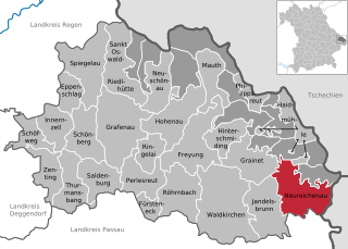
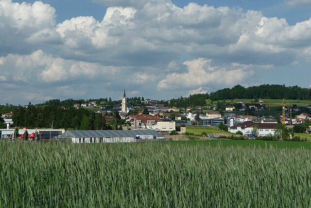
Freyung-Grafenau (Landkreis Freyung-Grafenau)

- district in Bavaria, Germany
 Hiking in Freyung-Grafenau
Freyung-Grafenau is a beautiful district located in Bavaria, Germany, known for its stunning landscapes, dense forests, and rugged terrain, making it a great destination for hiking enthusiasts. Here are some highlights and trails to consider when hiking in the area:
1.
- Granite Trail (Granitzweg): This trail takes you through the picturesque Bavarian Forest National Park and offers stunning vistas, unique rock formations, and diverse flora and fauna.
- Goldsteig Trail: This long-distance walking trail runs through the region, highlighting the natural beauty and cultural heritage of the Bavarian Forest, with various stages suitable for day hikes.
2.
- Many trails in the Freyung-Grafenau area are well-marked and accessible for hikers of all skill levels. Whether you're looking for easy strolls through the forest or more challenging mountain hikes, there's something for everyone.
3.
- Rachel and Lusen Mountains: These prominent peaks offer excellent hiking opportunities with panoramic views of the surrounding forest and valley below.
- Bavarian Forest National Park: The park is perfect for nature lovers and hikers who want to experience the natural landscape, with various trails for different abilities, including family-friendly routes.
4.
- The region is home to a plethora of wildlife, including deer, wild boars, and various bird species. Bring your binoculars for a chance to observe them in their natural habitat along the trails.
5.
- Expect to encounter charming villages along the hiking routes where you can experience local Bavarian culture, cuisine, and hospitality. Be sure to stop at a local gasthaus for a hearty meal and refreshing Bavarian beer after your hike.
6.
- Always check weather conditions and trail statuses before heading out. Dress appropriately for the weather and wear sturdy hiking boots. It's also a good idea to carry water, snacks, and a basic first aid kit.
7.
- If you're unfamiliar with the area or prefer guided experiences, consider joining a local hiking group or hiring a guide. They can provide insights into the region's history and ecology while ensuring a safe hiking experience.
Conclusion
Overall, hiking in Freyung-Grafenau allows you to immerse yourself in the natural beauty of the Bavarian Forest, offering a refreshing escape into nature. Whether you're tackling a challenging summit or enjoying a leisurely forest stroll, the region's varied landscapes and rich biodiversity make it a top destination for hikers of all levels.
- Country:

- Capital: Freyung
- Licence Plate Code: WOS; GRA; FRG
- Coordinates: 48° 49' 48" N, 13° 30' 0" E


- GPS tracks (wikiloc): [Link]
- AboveSeaLevel: 693 м m
- Area: 984.00 sq km
- Population: 75564
- Web site: http://www.freyung-grafenau.de/
- Wikipedia en: wiki(en)
- Wikipedia: wiki(de)
- Wikidata storage: Wikidata: Q10487
- Wikipedia Commons Category: [Link]
- Freebase ID: [/m/01pwml]
- GeoNames ID: Alt: [2918364]
- VIAF ID: Alt: [236784816]
- OSM relation ID: [2083466]
- GND ID: Alt: [4018493-6]
- archINFORM location ID: [4214]
- TGN ID: [7186239]
- Bavarikon ID: [ODB_A00001458]
- NUTS code: [DE225]
- BabelNet ID: [02216707n]
- German district key: 09272
Includes regions:
Frauenberger und Duschlberger Wald
- unincorporated area in Germany
Hiking in Frauenberger und Duschlberger Wald
Frauenberger und Duschlberger Wald, located in Germany, is a great spot for hiking enthusiasts seeking a blend of natural beauty and tranquility. The forest features a variety of trails suitable for different skill levels, from easy walks for families to more challenging routes for experienced hikers....
- Country:
- Coordinates: 48° 47' 0" N, 13° 47' 0" E
- GPS tracks (wikiloc): [Link]
Leopoldsreuter Wald
- unincorporated area in Germany
Hiking in Leopoldsreuter Wald
Leopoldsreuter Wald, located in Bavaria, Germany, is a wonderful destination for hiking enthusiasts. This forested area is characterized by its scenic landscapes, tranquil trails, and diverse flora and fauna. Here are some key points to keep in mind when planning a hiking trip in Leopoldsreuter Wald:...
- Country:
- Coordinates: 48° 50' 0" N, 13° 42' 0" E
- GPS tracks (wikiloc): [Link]


Mauther Forst
- unincorporated area in Germany
Hiking in Mauther Forst
Mauther Forst, located in Germany, is a beautiful natural area ideal for hiking enthusiasts looking for a mix of scenic forests, diverse wildlife, and an opportunity to connect with nature. Here are some key points to consider when hiking in Mauther Forst:...
- Country:
- Coordinates: 48° 57' 0" N, 13° 33' 0" E
- GPS tracks (wikiloc): [Link]
Philippsreuter Wald
- unincorporated area in Germany
Hiking in Philippsreuter Wald
Philippsreuter Wald, located in Germany, is a beautiful forest area that offers a range of hiking opportunities, making it a great destination for outdoor enthusiasts. The forest features picturesque landscapes, diverse wildlife, and a variety of trails suitable for different skill levels. Here are some highlights to consider:...
- Country:
- Coordinates: 48° 52' 0" N, 13° 42' 0" E
- GPS tracks (wikiloc): [Link]


Pleckensteiner Wald
- unincorporated area in Germany
Hiking in Pleckensteiner Wald
Pleckensteiner Wald is a beautiful forested area located in Bavaria, Germany, near the border with the Czech Republic. It’s part of the larger Bavarian Forest and offers diverse opportunities for hiking enthusiasts. Here are some details to help you enjoy your hiking experience in this region:...
- Country:
- Coordinates: 48° 46' 0" N, 13° 47' 0" E
- GPS tracks (wikiloc): [Link]
- AboveSeaLevel: 997 м m

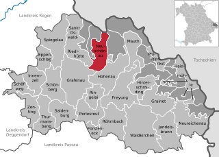
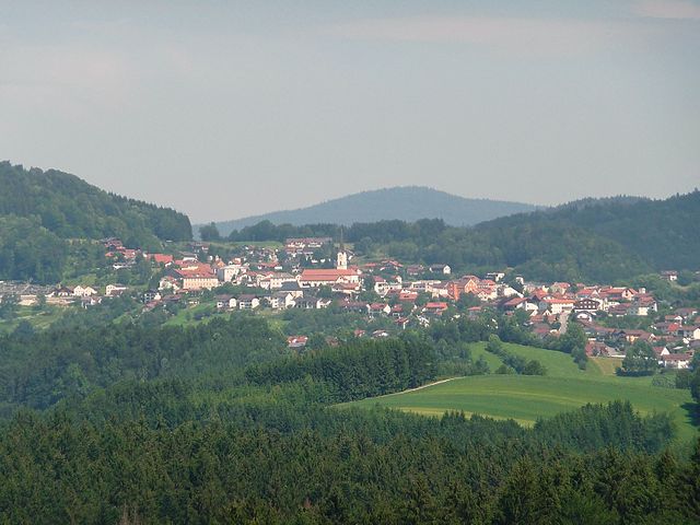
Neuschönau
- municipality of Germany
Hiking in Neuschönau
Neuschönau is a picturesque village located in the Bavarian Forest of Germany, making it a wonderful destination for hiking enthusiasts. The surrounding area is home to scenic trails that showcase the region's natural beauty, with dense forests, rolling hills, and panoramic views. Here are some key points to consider when hiking in Neuschönau:...
- Country:
- Postal Code: 94556
- Local Dialing Code: 08558
- Licence Plate Code: FRG
- Coordinates: 48° 53' 4" N, 13° 28' 40" E
- GPS tracks (wikiloc): [Link]
- AboveSeaLevel: 752 м m
- Area: 27.51 sq km
- Population: 2212
- Web site: [Link]


Zenting
- municipality of Germany
Hiking in Zenting
Zenting, located in Bavaria, Germany, is surrounded by beautiful landscapes perfect for hiking enthusiasts. Here are some details to consider when planning your hikes in the Zenting area:...
- Country:
- Postal Code: 94579
- Local Dialing Code: 09907
- Licence Plate Code: FRG
- Coordinates: 48° 48' 0" N, 13° 16' 0" E
- GPS tracks (wikiloc): [Link]
- AboveSeaLevel: 450 м m
- Area: 22.26 sq km
- Population: 1170
- Web site: [Link]

Schönberg
- municipality in the district of Freyung-Grafenau in Bavaria in Germany
Hiking in Schönberg
Schönberg, located in Lower Bavaria, is a picturesque area known for its stunning natural landscapes and hiking opportunities. Here are some key features of hiking in this region:...
- Country:
- Postal Code: 94513
- Local Dialing Code: 08554
- Licence Plate Code: FRG
- Coordinates: 48° 50' 0" N, 13° 20' 0" E
- GPS tracks (wikiloc): [Link]
- AboveSeaLevel: 563 м m
- Area: 32.75 sq km
- Population: 3663
- Web site: [Link]

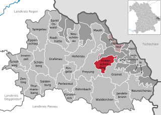
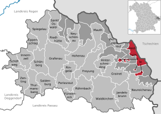
Hinterschmiding
- municipality of Germany
Hiking in Hinterschmiding
Hinterschmiding is a beautiful area located in Bavaria, Germany, nestled near the border with Austria. It's an excellent destination for hiking enthusiasts, offering a variety of trails that cater to different skill levels and preferences. Here are some highlights of hiking in Hinterschmiding:...
- Country:
- Postal Code: 94146
- Local Dialing Code: 08551
- Licence Plate Code: FRG
- Coordinates: 48° 49' 23" N, 13° 36' 4" E
- GPS tracks (wikiloc): [Link]
- AboveSeaLevel: 737 м m
- Area: 21.03 sq km
- Population: 2107
- Web site: [Link]
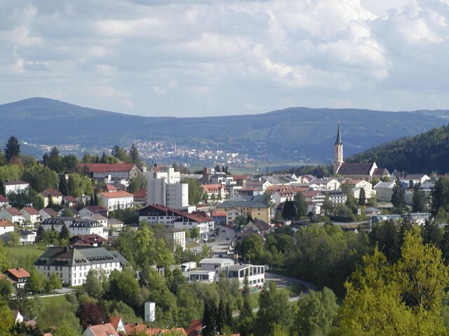

Freyung
- human settlement in Germany
Hiking in Freyung
Freyung, located in the Bavarian Forest in Germany, is a beautiful destination for hiking enthusiasts. The region is known for its stunning natural landscapes, rolling hills, dense forests, and picturesque villages. Here are some highlights about hiking in Freyung:...
- Country:
- Postal Code: 94078
- Local Dialing Code: 08558; 08551
- Licence Plate Code: FRG
- Coordinates: 48° 48' 27" N, 13° 32' 51" E
- GPS tracks (wikiloc): [Link]
- AboveSeaLevel: 655 м m
- Area: 48.63 sq km
- Population: 7124
- Web site: [Link]


Eppenschlag
- municipality of Germany
Hiking in Eppenschlag
Eppenschlag is a charming town located in the Bavaria region of Germany, surrounded by beautiful landscapes that offer a variety of hiking opportunities. Here are some highlights and tips for hiking in and around Eppenschlag:...
- Country:
- Postal Code: 94536
- Local Dialing Code: 09928
- Licence Plate Code: FRG
- Coordinates: 48° 53' 0" N, 13° 18' 0" E
- GPS tracks (wikiloc): [Link]
- AboveSeaLevel: 608 м m
- Area: 17.03 sq km
- Population: 890
- Web site: [Link]


Thurmansbang
- municipality of Germany
Hiking in Thurmansbang
Thurmansbang is a picturesque village located in Bavaria, Germany, surrounded by the beautiful landscape of the Bavarian Forest. It's an excellent destination for hiking enthusiasts, offering a variety of trails that cater to different skill levels and preferences....
- Country:
- Postal Code: 94169
- Local Dialing Code: 08504
- Licence Plate Code: FRG
- Coordinates: 48° 46' 0" N, 13° 19' 0" E
- GPS tracks (wikiloc): [Link]
- AboveSeaLevel: 494 м m
- Area: 32.93 sq km
- Population: 2159
- Web site: [Link]


Schöfweg
- municipality of Germany
Hiking in Schöfweg
Schöfweg, located in the Bavarian Forest in Germany, offers beautiful hiking opportunities for outdoor enthusiasts. The region is known for its stunning natural landscapes, dense forests, and diverse wildlife, making it a great destination for hikers of all skill levels....
- Country:
- Postal Code: 94572
- Local Dialing Code: 09908
- Licence Plate Code: FRG
- Coordinates: 48° 50' 20" N, 13° 13' 43" E
- GPS tracks (wikiloc): [Link]
- AboveSeaLevel: 772 м m
- Area: 19.02 sq km
- Population: 1174
- Web site: [Link]

Ringelai
- municipality of Germany
Hiking in Ringelai
Ringelai is a picturesque village located in Bavaria, Germany, surrounded by beautiful landscapes that make it an excellent destination for hiking enthusiasts. Here are some key points about hiking in and around Ringelai:...
- Country:
- Postal Code: 94160
- Local Dialing Code: 08555
- Licence Plate Code: FRG
- Coordinates: 48° 48' 49" N, 13° 28' 15" E
- GPS tracks (wikiloc): [Link]
- AboveSeaLevel: 425 м m
- Area: 16.37 sq km
- Population: 1813
- Web site: [Link]

Röhrnbach
- municipality of Germany
Hiking in Röhrnbach
Röhrnbach is a beautiful municipality located in Bavaria, Germany, nestled in the heart of the picturesque landscape of the Bavarian Forest. The area offers a variety of hiking opportunities suitable for different skill levels and preferences....
- Country:
- Postal Code: 94133
- Local Dialing Code: 08582
- Licence Plate Code: FRG
- Coordinates: 48° 44' 20" N, 13° 31' 23" E
- GPS tracks (wikiloc): [Link]
- AboveSeaLevel: 438 м m
- Area: 40.62 sq km
- Population: 4145
- Web site: [Link]


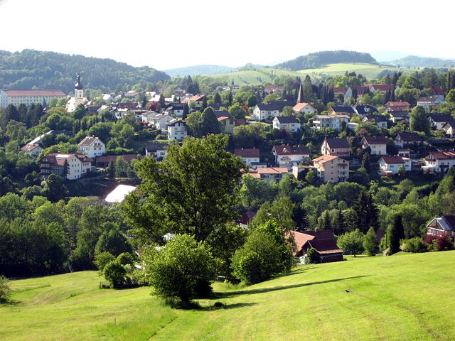
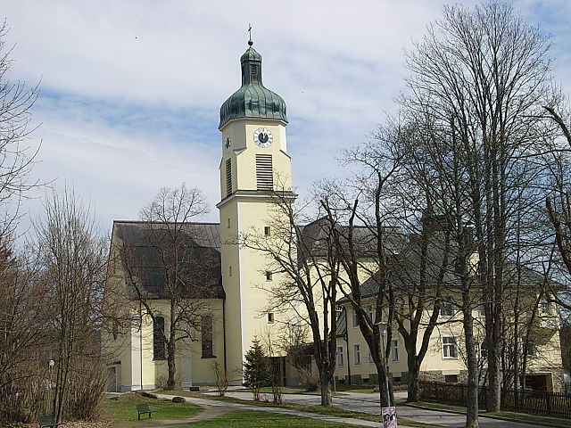
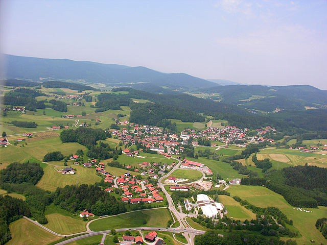
Mauth
- municipality of Germany
Hiking in Mauth
Mauth is a charming village located in the Bavarian Forest region of Germany, known for its picturesque landscapes, lush forests, and excellent hiking opportunities. This region offers a variety of trails that cater to different skill levels, making it a popular destination for both beginners and experienced hikers....
- Country:
- Postal Code: 94151
- Local Dialing Code: 08557
- Licence Plate Code: FRG
- Coordinates: 48° 53' 23" N, 13° 35' 5" E
- GPS tracks (wikiloc): [Link]
- AboveSeaLevel: 821 м m
- Area: 28.88 sq km
- Population: 2478
- Web site: [Link]


Saldenburg
- municipality of Germany
Hiking in Saldenburg
Saldenburg, located in Bavaria, Germany, is a charming area that offers a variety of hiking opportunities amidst beautiful natural landscapes. Known for its picturesque countryside, forests, and hills, Saldenburg is an excellent destination for hikers of all levels....
- Country:
- Postal Code: 94163
- Local Dialing Code: 08504
- Licence Plate Code: FRG
- Coordinates: 48° 47' 0" N, 13° 21' 0" E
- GPS tracks (wikiloc): [Link]
- AboveSeaLevel: 532 м m
- Area: 28.04 sq km
- Population: 1982
- Web site: [Link]
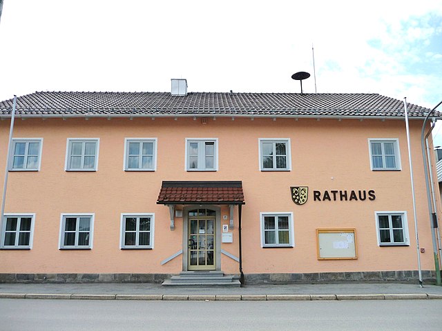
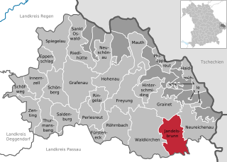
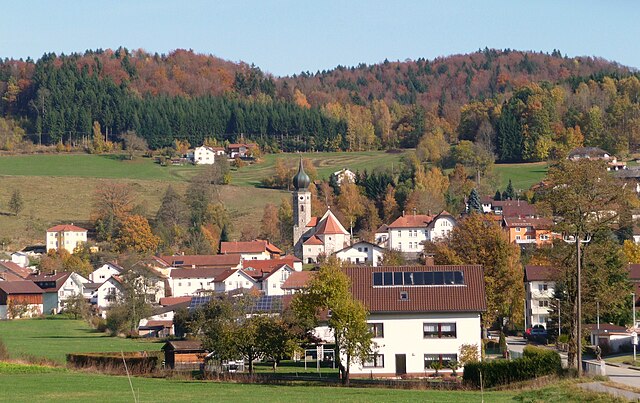
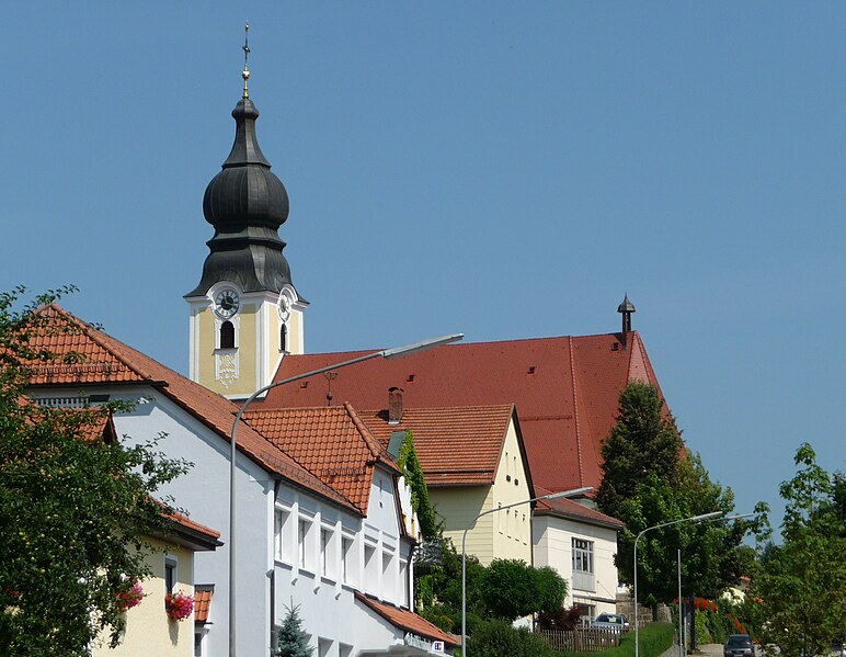
Jandelsbrunn
- municipality of Germany
Hiking in Jandelsbrunn
Jandelsbrunn is a small community in Bavaria, Germany, known for its beautiful natural landscape, making it a great destination for hikers. Nestled in the foothills of the Bavarian Forest, Jandelsbrunn offers a variety of trails that cater to hikers of different skill levels, from leisurely walks to more challenging hikes....
- Country:
- Postal Code: 94118
- Local Dialing Code: 08583
- Licence Plate Code: FRG
- Coordinates: 48° 44' 0" N, 13° 42' 0" E
- GPS tracks (wikiloc): [Link]
- AboveSeaLevel: 657 м m
- Area: 42.38 sq km
- Population: 3118
- Web site: [Link]

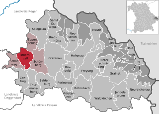
Innernzell
- municipality of Germany
Hiking in Innernzell
Innernzell is a charming village located in Bavaria, Germany, known for its beautiful landscapes and outdoor recreational opportunities. Situated near the foothills of the Bavarian Forest, it's an excellent starting point for various hiking adventures....
- Country:
- Postal Code: 94548
- Local Dialing Code: 08554
- Licence Plate Code: FRG
- Coordinates: 48° 51' 0" N, 13° 16' 0" E
- GPS tracks (wikiloc): [Link]
- AboveSeaLevel: 636 м m
- Area: 22.12 sq km
- Population: 1542
- Web site: [Link]


Perlesreut
- municipality of Germany
Hiking in Perlesreut
Perlesreut is a charming village located in Bavaria, Germany, close to the border with the Czech Republic. It’s situated in a picturesque region that offers a range of hiking opportunities, making it a great destination for both novice and experienced hikers....
- Country:
- Postal Code: 94157
- Local Dialing Code: 08555
- Licence Plate Code: FRG
- Coordinates: 48° 47' 0" N, 13° 27' 0" E
- GPS tracks (wikiloc): [Link]
- AboveSeaLevel: 542 м m
- Area: 29.73 sq km
- Population: 2686
- Web site: [Link]


Philippsreut
- municipality of Germany
Hiking in Philippsreut
Philippsreut is a charming village located in Bavaria, Germany, near the border with the Czech Republic. It offers a variety of hiking opportunities suitable for different skill levels, making it a great destination for outdoor enthusiasts. Here are some highlights regarding hiking in Philippsreut:...
- Country:
- Postal Code: 94158
- Local Dialing Code: 08550
- Licence Plate Code: FRG
- Coordinates: 48° 52' 0" N, 13° 41' 0" E
- GPS tracks (wikiloc): [Link]
- AboveSeaLevel: 943 м m
- Area: 10.22 sq km
- Population: 715
- Web site: [Link]


Fürsteneck
- municipality of Germany
Hiking in Fürsteneck
Fürsteneck, located in Bavaria, Germany, is a great destination for hiking enthusiasts due to its beautiful landscapes and well-marked trails. Nestled among lush forests and rolling hills, it offers various hiking routes suitable for different skill levels. Here are some highlights and tips for hiking in Fürsteneck:...
- Country:
- Postal Code: 94142
- Local Dialing Code: 08555
- Licence Plate Code: FRG
- Coordinates: 48° 43' 0" N, 13° 28' 0" E
- GPS tracks (wikiloc): [Link]
- AboveSeaLevel: 395 м m
- Area: 10.43 sq km
- Population: 813
- Web site: [Link]


Sankt Oswald-Riedlhütte
- municipality of Germany
Hiking in Sankt Oswald-Riedlhütte
Sankt Oswald-Riedlhütte, located in the Bavarian Forest National Park in Germany, is a fantastic destination for hiking enthusiasts. The area is known for its stunning landscapes, diverse flora and fauna, and well-maintained trail systems. Here are some highlights and tips for hiking in this region:...
- Country:
- Postal Code: 94568; 94566
- Local Dialing Code: 08553
- Licence Plate Code: FRG
- Coordinates: 48° 53' 0" N, 13° 25' 0" E
- GPS tracks (wikiloc): [Link]
- AboveSeaLevel: 791 м m
- Area: 40.34 sq km
- Population: 3103
- Web site: [Link]

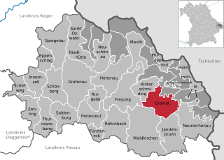
Grainet
- municipality of Germany
Hiking in Grainet
Grainet is a picturesque village located in Bavaria, Germany, known for its stunning natural landscapes and opportunities for outdoor activities, particularly hiking. Here are some highlights and tips for hiking in the Grainet area:...
- Country:
- Postal Code: 94143
- Local Dialing Code: 08585
- Licence Plate Code: FRG
- Coordinates: 48° 48' 0" N, 13° 39' 0" E
- GPS tracks (wikiloc): [Link]
- AboveSeaLevel: 694 м m
- Area: 36.12 sq km
- Population: 2112
- Web site: [Link]


Hohenau
- municipality of Germany
Hiking in Hohenau
Hohenau, a picturesque village in Bavaria, Germany, offers a variety of hiking opportunities that cater to different skill levels and preferences. Nestled within the beautiful foothills of the Bavarian Forest, the region is marked by dense forests, rolling hills, and scenic landscapes....
- Country:
- Postal Code: 94545
- Local Dialing Code: 08558
- Licence Plate Code: FRG
- Coordinates: 48° 51' 0" N, 13° 29' 19" E
- GPS tracks (wikiloc): [Link]
- AboveSeaLevel: 804 м m
- Area: 43.1 sq km
- Population: 3288
- Web site: [Link]

Haidmühle
- municipality of Germany
Hiking in Haidmühle
Haidmühle, a charming village in Bavaria, Germany, is an excellent destination for hiking enthusiasts. Nestled in the picturesque landscape of the Bavarian Forest, it offers a variety of hiking trails suitable for different skill levels. Here are some highlights and tips for hiking in Haidmühle:...
- Country:
- Postal Code: 94145
- Local Dialing Code: 08556
- Licence Plate Code: FRG
- Coordinates: 48° 49' 36" N, 13° 46' 31" E
- GPS tracks (wikiloc): [Link]
- AboveSeaLevel: 831 м m
- Area: 21.03 sq km
- Population: 1526
- Web site: [Link]

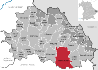
Waldkirchen
- municipality of Germany
Hiking in Waldkirchen
Waldkirchen, located in the Bavarian region of Germany, is a beautiful destination for hiking enthusiasts. Known for its stunning landscapes, lush forests, and scenic views, the area offers various trails suitable for different skill levels....
- Country:
- Postal Code: 94065
- Local Dialing Code: 08581
- Licence Plate Code: FRG
- Coordinates: 48° 43' 50" N, 13° 36' 4" E
- GPS tracks (wikiloc): [Link]
- AboveSeaLevel: 532 м m
- Area: 80.01 sq km
- Population: 9448
- Web site: [Link]

Neureichenau
- municipality of Germany
Hiking in Neureichenau
Neureichenau is a beautiful area in Bavaria, Germany, located near the borders of the Czech Republic and Austria. It's characterized by its stunning landscapes, rolling hills, and diverse flora and fauna, making it an excellent destination for hiking enthusiasts....
- Country:
- Postal Code: 94089
- Local Dialing Code: 08583
- Licence Plate Code: FRG
- Coordinates: 48° 45' 0" N, 13° 45' 0" E
- GPS tracks (wikiloc): [Link]
- AboveSeaLevel: 669 м m
- Area: 46.37 sq km
- Population: 4182
- Web site: [Link]

Grafenau
- municipality in Bavaria, Germany
Hiking in Grafenau
Grafenau, located in the Lower Bavarian region of Germany, is a delightful destination for hiking enthusiasts. It is surrounded by stunning natural landscapes, including the Bavarian Forest National Park, which provides a variety of trails suitable for all skill levels....
- Country:
- Postal Code: 94568; 94481
- Local Dialing Code: 08552
- Coordinates: 48° 51' 22" N, 13° 23' 49" E
- GPS tracks (wikiloc): [Link]
- AboveSeaLevel: 609 м m
- Area: 63.73 sq km
- Population: 8093
- Web site: [Link]

Spiegelau
- municipality of Germany
Hiking in Spiegelau
Spiegelau, located in the Bavarian Forest National Park in Germany, is an excellent destination for hiking enthusiasts. The area is characterized by its beautiful landscapes, dense forests, and a variety of trails catering to different skill levels. Here’s what you can expect when hiking in and around Spiegelau:...
- Country:
- Postal Code: 94518
- Local Dialing Code: 08553
- Licence Plate Code: FRG
- Coordinates: 48° 55' 0" N, 13° 22' 0" E
- GPS tracks (wikiloc): [Link]
- AboveSeaLevel: 759 м m
- Area: 47.03 sq km
- Population: 4064
- Web site: [Link]
Annathaler Wald
- unincorporated area in Germany
Hiking in Annathaler Wald
Annathaler Wald, located in Germany, offers a beautiful natural setting for hiking enthusiasts. This forest area is characterized by lush greenery, diverse flora, and a variety of trails suitable for different skill levels. Here are some highlights and tips for hiking in Annathaler Wald:...
- Country:
- Coordinates: 48° 53' 0" N, 13° 37' 0" E
- GPS tracks (wikiloc): [Link]
Graineter Wald
- unincorporated area in Germany
Hiking in Graineter Wald
Graineter Wald is a beautiful forest located in the region of Bavaria, Germany. It offers a range of hiking opportunities for outdoor enthusiasts, with its lush forests, scenic paths, and rich wildlife. Here are some key points to consider when planning a hike in the Graineter Wald:...
- Country:
- Coordinates: 48° 49' 0" N, 13° 41' 0" E
- GPS tracks (wikiloc): [Link]
Sankt Oswald
- unincorporated area in Germany
Hiking in Sankt Oswald
Sankt Oswald, located in Bavaria, Germany, is known for its beautiful landscapes and extensive network of hiking trails. The area is part of the larger Bavarian Forest National Park, which offers a variety of options for hikers of all skill levels, from easy walks to more challenging treks....
- Country:
- Coordinates: 48° 56' 0" N, 13° 26' 0" E
- GPS tracks (wikiloc): [Link]
Schlichtenberger Wald
- unincorporated area in Germany
Hiking in Schlichtenberger Wald
Schlichtenberger Wald is part of the beautiful German landscape, known for its lush forests and picturesque trails, making it a great destination for hiking enthusiasts. Here’s what you can expect when hiking in this area:...
- Country:
- Coordinates: 48° 51' 0" N, 13° 38' 0" E
- GPS tracks (wikiloc): [Link]
Schönbrunner Wald
- unincorporated area in Germany
Hiking in Schönbrunner Wald
Schönbrunner Wald is a beautiful area located near Vienna, Austria, primarily known for its lush greenery, diverse wildlife, and stunning landscapes. It's an excellent destination for hikers of all levels, offering a variety of trails that cater to different experiences....
- Country:
- Coordinates: 48° 54' 0" N, 13° 31' 0" E
- GPS tracks (wikiloc): [Link]
Waldhäuserwald
- unincorporated area in Germany
Hiking in Waldhäuserwald
Waldhäuserwald is a picturesque woodland area that offers a variety of hiking opportunities. While specific details may vary depending on the exact location you're referring to, many forests with that name tend to share common features and trails that can appeal to hikers of all levels. Here’s what you can generally expect:...
- Country:
- Coordinates: 48° 56' 0" N, 13° 27' 0" E
- GPS tracks (wikiloc): [Link]
Shares border with regions:
Regen district
- district in Bavaria, Germany
Hiking in Regen district
Hiking in the Regen district, located in Bavaria, Germany, offers a stunning blend of natural beauty, cultural attractions, and outdoor adventure. The region is known for its picturesque landscapes, featuring lush forests, rolling hills, and the scenic Danube and Regen rivers. Here are some highlights and tips for hiking in this area:...
- Country:
- Capital: Regen
- Licence Plate Code: REG
- Coordinates: 49° 0' 0" N, 13° 10' 12" E
- GPS tracks (wikiloc): [Link]
- AboveSeaLevel: 686 м m
- Area: 975.00 sq km
- Population: 76135
- Web site: [Link]


Deggendorf
- district in Bavaria, Germany
Hiking in Deggendorf
Deggendorf, located in Bavaria, Germany, is a fantastic region for hiking enthusiasts. Nestled at the edge of the Bavarian Forest National Park and alongside the Danube River, it boasts a variety of landscapes and trails suitable for all skill levels....
- Country:
- Capital: Deggendorf
- Licence Plate Code: DEG
- Coordinates: 48° 49' 48" N, 13° 0' 0" E
- GPS tracks (wikiloc): [Link]
- AboveSeaLevel: 309 м m
- Area: 861.00 sq km
- Population: 115005
- Web site: [Link]

Passau
- district of Bavaria, Germany
Hiking in Passau
Hiking in the Passau district, located in the southeast of Bavaria, Germany, offers an array of scenic trails and beautiful landscapes characterized by hills, forests, rivers, and charming villages. The Passau area is known for its impressive natural beauty, making it a great destination for hikers of all experience levels. Below are some highlights of hiking in the region:...
- Country:
- Capital: Passau
- Licence Plate Code: PA
- Coordinates: 48° 30' 0" N, 13° 19' 48" E
- GPS tracks (wikiloc): [Link]
- AboveSeaLevel: 364 м m
- Area: 1530.04 sq km
- Population: 162355
- Web site: [Link]
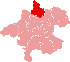
Rohrbach District
- district of Austria
Hiking in Rohrbach District
Rohrbach District, located in the southwestern part of Germany, offers a variety of hiking opportunities amidst its scenic landscapes, charming villages, and historical sites. The area is characterized by diverse terrain, including forested hills, meadows, and picturesque valleys, making it an excellent destination for hikers of all skill levels....
- Country:

- Capital: Rohrbach in Oberösterreich
- Licence Plate Code: RO
- Coordinates: 48° 32' 38" N, 13° 58' 23" E
- GPS tracks (wikiloc): [Link]
- AboveSeaLevel: 583 м m
- Area: 817.19 sq km
- Web site: [Link]