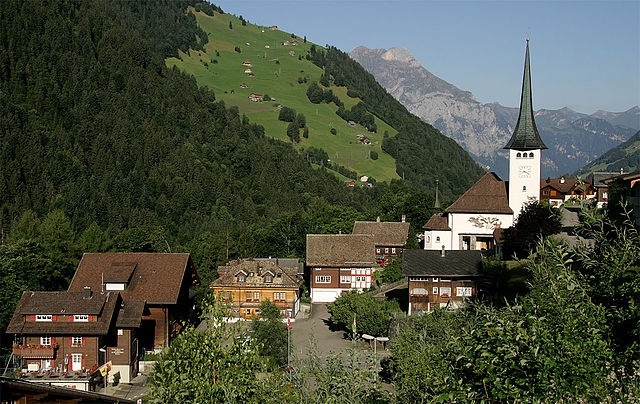
Schattdorf (Schattdorf)

- municipality in Switzerland
 Hiking in Schattdorf
Schattdorf is a charming village located in the Canton of Uri in Switzerland, surrounded by stunning mountain landscapes, making it an excellent destination for hiking enthusiasts. Here are some highlights and tips for hiking in this area:
Hiking Trails
-
Bristen Mountain: This is a popular hike starting from Schattdorf that offers breathtaking views of the surrounding Alps. The trail can be steep in sections but is well-marked. It’s suitable for experienced hikers looking for a challenge.
-
Muotathal Valley: Accessible from Schattdorf, this area offers a variety of trails that cater to different skill levels. The valley is known for its impressive natural scenery, including gorges and waterfalls.
-
Uri Alps: The trails in this region provide ample opportunities to explore alpine meadows, rocky terrains, and scenic viewpoints. Look for routes that lead to summits for panoramic views.
-
Lake Lucerne Trails: Some hikes connect to the shores of Lake Lucerne, which offers beautiful lake views and charming picnic spots.
Preparation Tips
- Weather: Always check the local weather conditions before heading out. The weather can change rapidly in the mountains.
- Equipment: Make sure you have proper hiking boots, a good backpack, and adequate clothing for varying temperatures and conditions.
- Maps: Obtain a hiking map of the area or download a hiking app to ensure you stay on marked trails.
Safety
- Trail Markings: The trails in Switzerland are usually well-marked, but it’s essential to stay on the designated paths to avoid getting lost.
- Inform Someone: Let someone know your plans before you hike, especially if you’re going into less populated areas.
Local Tips
- Transportation: Schattdorf is well-connected by public transport, making it easy to reach starting points for various hikes.
- Local Cuisine: Don’t miss trying local Swiss dishes at nearby restaurants. After a long hike, enjoying a hearty meal can be very satisfying.
Seasonal Considerations
- Spring and Summer: This is peak hiking season, with blooming flowers and clear trails.
- Fall: Offers beautiful autumn colors, but be cautious of changing weather.
- Winter: Some trails may be accessible for snowshoeing, but ensure you check conditions and safety measures.
By exploring the hiking opportunities around Schattdorf, you can experience the natural beauty of the Swiss Alps along with local culture and warmth. Happy hiking!
- Country:

- Postal Code: 6467
- Local Dialing Code: 041
- Licence Plate Code: UR
- Coordinates: 46° 50' 58" N, 8° 40' 17" E


- GPS tracks (wikiloc): [Link]
- AboveSeaLevel: 1190 м m
- Area: 16.31 sq km
- Population: 5382
- Web site: http://www.schattdorf.ch
- Wikipedia en: wiki(en)
- Wikipedia: wiki(de)
- Wikidata storage: Wikidata: Q66635
- Wikipedia Commons Category: [Link]
- Freebase ID: [/m/0fwqd2]
- GeoNames ID: Alt: [7287077]
- VIAF ID: Alt: [141944219]
- OSM relation ID: [1683102]
- HDS ID: [702]
- Swiss municipality code: [1213]
Shares border with regions:


Unterschächen
- municipality in Switzerland
Hiking in Unterschächen
Unterschächen is a picturesque village located in the heart of the Swiss Alps, specifically in the canton of Uri. It's a great destination for hiking enthusiasts due to its stunning mountain scenery and a variety of trails suitable for different skill levels....
- Country:
- Postal Code: 6465
- Local Dialing Code: 041
- Licence Plate Code: UR
- Coordinates: 46° 51' 30" N, 8° 47' 37" E
- GPS tracks (wikiloc): [Link]
- AboveSeaLevel: 1552 м m
- Area: 80.33 sq km
- Population: 714
- Web site: [Link]

Silenen
- municipality in the canton of Uri, Switzerland
Hiking in Silenen
Silenen, a charming municipality in the canton of Uri, Switzerland, is an excellent destination for hiking enthusiasts. Nestled in a picturesque valley, Silenen offers breathtaking views of the surrounding mountains and is a great starting point for various hiking trails suitable for all levels of experience....
- Country:
- Postal Code: 6473
- Local Dialing Code: 041
- Licence Plate Code: UR
- Coordinates: 46° 47' 28" N, 8° 40' 9" E
- GPS tracks (wikiloc): [Link]
- AboveSeaLevel: 510 м m
- Area: 144.78 sq km
- Population: 1991
- Web site: [Link]

Attinghausen
- municipality in Switzerland
Hiking in Attinghausen
Attinghausen is a charming village located in the Canton of Uri, Switzerland, surrounded by stunning alpine landscapes and offering a variety of hiking opportunities. Here are some highlights for hiking in and around Attinghausen:...
- Country:
- Postal Code: 6468
- Local Dialing Code: 041
- Licence Plate Code: UR
- Coordinates: 46° 49' 42" N, 8° 32' 37" E
- GPS tracks (wikiloc): [Link]
- AboveSeaLevel: 2109 м m
- Area: 46.83 sq km
- Population: 1711
- Web site: [Link]


Bürglen
- municipality in the canton of Uri, Switzerland
Hiking in Bürglen
Bürglen is a picturesque village located in the Uri region of Switzerland, surrounded by stunning alpine landscapes and rich cultural history. The area is perfect for hiking enthusiasts, offering a variety of trails that cater to different skill levels....
- Country:
- Postal Code: 6463
- Local Dialing Code: 041
- Licence Plate Code: UR
- Coordinates: 46° 52' 30" N, 8° 39' 46" E
- GPS tracks (wikiloc): [Link]
- AboveSeaLevel: 525 м m
- Area: 53.14 sq km
- Population: 3982
- Web site: [Link]


Erstfeld
- municipality in Switzerland
Hiking in Erstfeld
Erstfeld, located in the canton of Uri in Switzerland, is an excellent destination for hiking enthusiasts. The region is known for its stunning alpine scenery, charming villages, and diverse trails that cater to various skill levels. Here are some highlights of hiking in Erstfeld:...
- Country:
- Postal Code: 6472
- Local Dialing Code: 041
- Licence Plate Code: UR
- Coordinates: 46° 48' 45" N, 8° 35' 58" E
- GPS tracks (wikiloc): [Link]
- AboveSeaLevel: 1067 м m
- Area: 59.2 sq km
- Population: 3781
- Web site: [Link]
Spiringen
- municipality in Switzerland
Hiking in Spiringen
Spiringen is a picturesque village located in the Canton of Uri, Switzerland, and is a great destination for hiking enthusiasts. Nestled in the Urner Valley, it offers stunning views of the surrounding mountains and has access to a variety of hiking trails suitable for different skill levels....
- Country:
- Postal Code: 8751; 6464
- Local Dialing Code: 041
- Licence Plate Code: UR
- Coordinates: 46° 52' 42" N, 8° 50' 37" E
- GPS tracks (wikiloc): [Link]
- AboveSeaLevel: 2267 м m
- Area: 64.73 sq km
- Population: 843
- Web site: [Link]