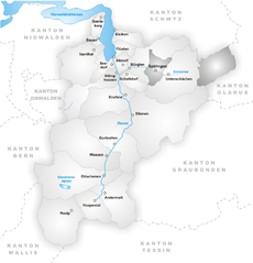
Spiringen (Spiringen)
- municipality in Switzerland
Spiringen is a picturesque village located in the Canton of Uri, Switzerland, and is a great destination for hiking enthusiasts. Nestled in the Urner Valley, it offers stunning views of the surrounding mountains and has access to a variety of hiking trails suitable for different skill levels.
Hiking Trails
-
Hiking to the Dammastock: The trail to Dammastock, the highest peak in the Urner Alps, provides breathtaking scenery and a challenging trek for experienced hikers. This hike typically involves alpine terrain and may require proper gear.
-
Spiringen to the Gotthard Pass: This historic trail offers a mix of natural beauty, cultural heritage, and historical significance as it follows part of the ancient trade routes.
-
Aar Gorge Trail: A more moderate hike, this trail takes you through stunning landscapes and natural rock formations. It's accessible for families and novice hikers.
-
Schächen Valley: This lesser-known valley trail is a great way to experience the serenity of the Swiss Alps, with lush green meadows, wildflowers, and the chance to spot local wildlife.
Tips for Hiking in Spiringen
- Check Weather Conditions: Weather can change quickly in the mountains, so always check the forecast and plan accordingly.
- Gear Up: Ensure you have appropriate hiking gear, including sturdy boots, clothing for various weather conditions, and a good backpack.
- Safety First: Carry a map or a GPS device, and inform someone about your hiking plans.
- Local Regulations: Respect local wildlife and nature. Stick to designated trails to minimize your impact on the environment.
- Hydration and Snacks: Carry plenty of water and nutritious snacks to keep your energy up.
Amenities
Spiringen also has accommodation options, local restaurants, and small shops where you can purchase supplies. It's a good idea to plan your stay in advance, especially during peak hiking seasons.
Overall, Spiringen is an excellent base for exploring the breathtaking Swiss landscape through hiking, offering both challenging treks and easy walks for all abilities, along with rich cultural experiences nearby.
- Country:

- Postal Code: 8751; 6464
- Local Dialing Code: 041
- Licence Plate Code: UR
- Coordinates: 46° 52' 42" N, 8° 50' 37" E


- GPS tracks (wikiloc): [Link]
- AboveSeaLevel: 2267 м m
- Area: 64.73 sq km
- Population: 843
- Web site: http://www.spiringen.ch
- Wikipedia en: wiki(en)
- Wikipedia: wiki(de)
- Wikidata storage: Wikidata: Q69663
- Wikipedia Commons Category: [Link]
- Freebase ID: [/m/0fwqkr]
- GeoNames ID: Alt: [7287205]
- VIAF ID: Alt: [236627960]
- OSM relation ID: [1683111]
- HDS ID: [707]
- Swiss municipality code: [1218]
Shares border with regions:


Unterschächen
- municipality in Switzerland
Unterschächen is a picturesque village located in the heart of the Swiss Alps, specifically in the canton of Uri. It's a great destination for hiking enthusiasts due to its stunning mountain scenery and a variety of trails suitable for different skill levels....
- Country:

- Postal Code: 6465
- Local Dialing Code: 041
- Licence Plate Code: UR
- Coordinates: 46° 51' 30" N, 8° 47' 37" E


- GPS tracks (wikiloc): [Link]
- AboveSeaLevel: 1552 м m
- Area: 80.33 sq km
- Population: 714
- Web site: [Link]


Muotathal
- municipality in Switzerland
Muotathal, located in the heart of Switzerland, offers stunning landscapes and diverse hiking opportunities, making it a fantastic destination for both novice and experienced hikers. Here are some highlights and tips for hiking in this beautiful region:...
- Country:

- Postal Code: 6436
- Local Dialing Code: 041
- Licence Plate Code: SZ
- Coordinates: 46° 58' 28" N, 8° 45' 28" E


- GPS tracks (wikiloc): [Link]
- AboveSeaLevel: 610 м m
- Area: 172.15 sq km
- Population: 3515
- Web site: [Link]


Schattdorf
- municipality in Switzerland
Schattdorf is a charming village located in the Canton of Uri in Switzerland, surrounded by stunning mountain landscapes, making it an excellent destination for hiking enthusiasts. Here are some highlights and tips for hiking in this area:...
- Country:

- Postal Code: 6467
- Local Dialing Code: 041
- Licence Plate Code: UR
- Coordinates: 46° 50' 58" N, 8° 40' 17" E


- GPS tracks (wikiloc): [Link]
- AboveSeaLevel: 1190 м m
- Area: 16.31 sq km
- Population: 5382
- Web site: [Link]


Silenen
- municipality in the canton of Uri, Switzerland
Silenen, a charming municipality in the canton of Uri, Switzerland, is an excellent destination for hiking enthusiasts. Nestled in a picturesque valley, Silenen offers breathtaking views of the surrounding mountains and is a great starting point for various hiking trails suitable for all levels of experience....
- Country:

- Postal Code: 6473
- Local Dialing Code: 041
- Licence Plate Code: UR
- Coordinates: 46° 47' 28" N, 8° 40' 9" E


- GPS tracks (wikiloc): [Link]
- AboveSeaLevel: 510 м m
- Area: 144.78 sq km
- Population: 1991
- Web site: [Link]


Bürglen
- municipality in the canton of Uri, Switzerland
Bürglen is a picturesque village located in the Uri region of Switzerland, surrounded by stunning alpine landscapes and rich cultural history. The area is perfect for hiking enthusiasts, offering a variety of trails that cater to different skill levels....
- Country:

- Postal Code: 6463
- Local Dialing Code: 041
- Licence Plate Code: UR
- Coordinates: 46° 52' 30" N, 8° 39' 46" E


- GPS tracks (wikiloc): [Link]
- AboveSeaLevel: 525 м m
- Area: 53.14 sq km
- Population: 3982
- Web site: [Link]


