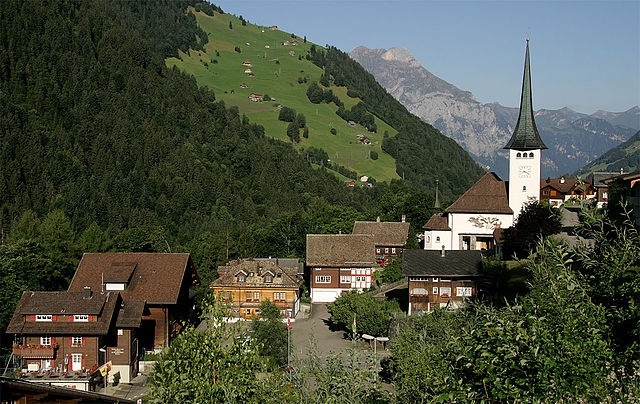
Silenen (Silenen)

- municipality in the canton of Uri, Switzerland
 Hiking in Silenen
Silenen, a charming municipality in the canton of Uri, Switzerland, is an excellent destination for hiking enthusiasts. Nestled in a picturesque valley, Silenen offers breathtaking views of the surrounding mountains and is a great starting point for various hiking trails suitable for all levels of experience.
Key Highlights of Hiking in Silenen:
-
Diverse Trails: There are numerous hiking trails in and around Silenen. These range from easy walks suitable for families to more challenging hikes that require a higher level of fitness. Many trails allow you to enjoy views of the Reuss Valley and the iconic surrounding peaks.
-
Alpine Scenery: The area is known for its stunning landscapes, including lush meadows, rocky outcrops, and charming alpine huts. Hikers can enjoy the beauty of wildflowers in the summer and dramatic snow-capped mountains in the winter.
-
Historical Routes: Some trails offer a glimpse into history, such as routes that pass by ancient trade paths or historical sites. These walks provide not only physical exercise but also cultural enrichment.
-
Accessibility: Silenen is easily accessible by public transportation, making it convenient for both locals and visitors. Additionally, the region has well-marked trails, which are easy to follow.
-
Activities Beyond Hiking: In addition to hiking, there are opportunities for other outdoor activities, such as rock climbing and mountain biking. The area is also known for its natural beauty in all seasons, making it a year-round destination.
-
Local Tips: Always check the weather conditions before heading out, as mountain weather can change rapidly. Proper gear, including sturdy hiking boots and sufficient water, is essential, especially for longer hikes.
-
Maps and Guides: It’s advisable to have a good map or to download a hiking app that covers the area. Local tourism offices or visitor centers can provide valuable information and updates on trail conditions.
Overall, hiking in Silenen offers a wonderful combination of natural beauty, outdoor adventure, and a taste of Swiss culture. Whether you're looking for a leisurely stroll or a more rigorous trek, you'll find it in this picturesque part of the Swiss Alps.
- Country:

- Postal Code: 6473
- Local Dialing Code: 041
- Licence Plate Code: UR
- Coordinates: 46° 47' 28" N, 8° 40' 9" E


- GPS tracks (wikiloc): [Link]
- AboveSeaLevel: 510 м m
- Area: 144.78 sq km
- Population: 1991
- Web site: http://www.silenen.ch
- Wikipedia en: wiki(en)
- Wikipedia: wiki(de)
- Wikidata storage: Wikidata: Q69135
- Wikipedia Commons Category: [Link]
- Freebase ID: [/m/0fwqjl]
- GeoNames ID: Alt: [7287171]
- VIAF ID: Alt: [240537591]
- OSM relation ID: [1683108]
- HDS ID: [705]
- Swiss municipality code: [1216]
Shares border with regions:

Tujetsch
- municipality in Switzerland
Hiking in Tujetsch
Tujetsch is a beautiful municipality located in the canton of Graubünden in Switzerland, known for its stunning landscapes and outdoor recreational opportunities. Hiking in Tujetsch offers a variety of trails suitable for different skill levels, ranging from leisurely walks to more challenging hikes. Here are some highlights and tips for hiking in this picturesque region:...
- Country:
- Postal Code: 7188
- Local Dialing Code: 081
- Licence Plate Code: GR
- Coordinates: 46° 40' 59" N, 8° 46' 0" E
- GPS tracks (wikiloc): [Link]
- AboveSeaLevel: 1450 м m
- Area: 134 sq km
- Population: 1256
- Web site: [Link]


Gurtnellen
- municipality in Switzerland
Hiking in Gurtnellen
Gurtnellen, located in the picturesque Uri region of Switzerland, is a great destination for hiking enthusiasts. Nestled in the heart of the Swiss Alps, it offers stunning views, varied terrain, and a range of hiking trails suited for different skill levels....
- Country:
- Postal Code: 6482
- Local Dialing Code: 041
- Licence Plate Code: UR
- Coordinates: 46° 44' 37" N, 8° 37' 26" E
- GPS tracks (wikiloc): [Link]
- AboveSeaLevel: 1104 м m
- Area: 83.35 sq km
- Population: 558
- Web site: [Link]


Unterschächen
- municipality in Switzerland
Hiking in Unterschächen
Unterschächen is a picturesque village located in the heart of the Swiss Alps, specifically in the canton of Uri. It's a great destination for hiking enthusiasts due to its stunning mountain scenery and a variety of trails suitable for different skill levels....
- Country:
- Postal Code: 6465
- Local Dialing Code: 041
- Licence Plate Code: UR
- Coordinates: 46° 51' 30" N, 8° 47' 37" E
- GPS tracks (wikiloc): [Link]
- AboveSeaLevel: 1552 м m
- Area: 80.33 sq km
- Population: 714
- Web site: [Link]


Schattdorf
- municipality in Switzerland
Hiking in Schattdorf
Schattdorf is a charming village located in the Canton of Uri in Switzerland, surrounded by stunning mountain landscapes, making it an excellent destination for hiking enthusiasts. Here are some highlights and tips for hiking in this area:...
- Country:
- Postal Code: 6467
- Local Dialing Code: 041
- Licence Plate Code: UR
- Coordinates: 46° 50' 58" N, 8° 40' 17" E
- GPS tracks (wikiloc): [Link]
- AboveSeaLevel: 1190 м m
- Area: 16.31 sq km
- Population: 5382
- Web site: [Link]


Disentis/Mustér
- resort and municipality in Surselva, Graubünden, Switzerland
Hiking in Disentis/Mustér
Disentis, located in the Swiss Canton of Graubünden, is a fantastic destination for hiking enthusiasts. This region is known for its breathtaking Alpine scenery, diverse landscapes, and rich cultural heritage. Here are some key points to consider when planning a hiking trip in Disentis:...
- Country:
- Postal Code: 7180
- Local Dialing Code: 081
- Licence Plate Code: GR
- Coordinates: 46° 44' 3" N, 8° 50' 51" E
- GPS tracks (wikiloc): [Link]
- AboveSeaLevel: 1130 м m
- Area: 90.98 sq km
- Population: 2092
- Web site: [Link]


Erstfeld
- municipality in Switzerland
Hiking in Erstfeld
Erstfeld, located in the canton of Uri in Switzerland, is an excellent destination for hiking enthusiasts. The region is known for its stunning alpine scenery, charming villages, and diverse trails that cater to various skill levels. Here are some highlights of hiking in Erstfeld:...
- Country:
- Postal Code: 6472
- Local Dialing Code: 041
- Licence Plate Code: UR
- Coordinates: 46° 48' 45" N, 8° 35' 58" E
- GPS tracks (wikiloc): [Link]
- AboveSeaLevel: 1067 м m
- Area: 59.2 sq km
- Population: 3781
- Web site: [Link]
Spiringen
- municipality in Switzerland
Hiking in Spiringen
Spiringen is a picturesque village located in the Canton of Uri, Switzerland, and is a great destination for hiking enthusiasts. Nestled in the Urner Valley, it offers stunning views of the surrounding mountains and has access to a variety of hiking trails suitable for different skill levels....
- Country:
- Postal Code: 8751; 6464
- Local Dialing Code: 041
- Licence Plate Code: UR
- Coordinates: 46° 52' 42" N, 8° 50' 37" E
- GPS tracks (wikiloc): [Link]
- AboveSeaLevel: 2267 м m
- Area: 64.73 sq km
- Population: 843
- Web site: [Link]

Glarus Süd
- municipality in Switzerland
Hiking in Glarus Süd
Glarus Süd, located in the canton of Glarus in Switzerland, is a fantastic destination for hiking enthusiasts. This region boasts stunning landscapes, ranging from lush valleys to rugged mountain terrains. Here are some key points about hiking in Glarus Süd:...
- Country:
- Postal Code: 8756, 8762, 8765, 8766, 8767, 8772, 8773, 8774, 8775, 8777, 8782, 8783, 8784
- Local Dialing Code: 055
- Licence Plate Code: GL
- Coordinates: 46° 59' 40" N, 9° 4' 27" E
- GPS tracks (wikiloc): [Link]
- AboveSeaLevel: 521 м m
- Area: 430.2 sq km
- Population: 9581
- Web site: [Link]