Schattenhalb (Schattenhalb)

- municipality in the canton of Bern, Switzerland
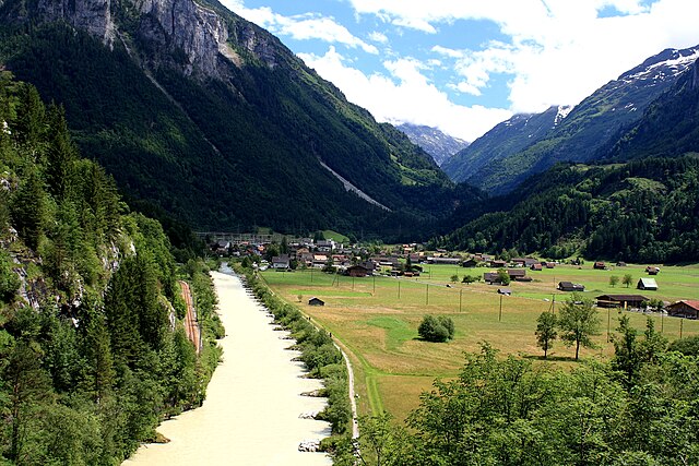
 Hiking in Schattenhalb
Schattenhalb is a picturesque area located in the Bernese Oberland of Switzerland, renowned for its stunning landscapes and excellent hiking opportunities. Here are some key points about hiking in this region:
Scenic Trails
-
Panoramic Views: The trails around Schattenhalb often provide breathtaking views of the surrounding mountains, including the famous Eiger, Mönch, and Jungfrau. This makes for excellent photo opportunities, especially at sunrise and sunset.
-
Variety of Trails: There are a variety of hiking trails in and around Schattenhalb, catering to different skill levels. Whether you're looking for a leisurely walk or a more challenging hike, you'll find something that suits your preference.
Popular Hiking Routes
-
Hiking to the First: A popular hike leads from Schattenhalb to the First, a mountain summit that offers incredible panoramic views and a variety of activities such as the First Cliff Walk, which features a suspension bridge.
-
The Panoramaweg: This trail offers a moderately challenging hike that showcases the beauty of the landscape. It connects several viewpoints and provides great spots for resting and taking in the scenery.
-
Schattenhalb to the Grosse Scheidegg: This hike takes you to Grosse Scheidegg, where you can enjoy dramatic views of the surrounding Alps. It’s a perfect route for those wanting a longer excursion.
Accessibility
-
Public Transport: Schattenhalb is accessible by train and bus, making it convenient for visitors coming from larger cities like Interlaken or Bern.
-
Seasonal Availability: Be mindful of the season when planning your hike. Summer and early autumn are generally the best times for hiking in this region, while winter may bring snow, making some trails impassable or requiring snow gear.
Safety and Preparation
-
Weather: The weather can change rapidly in the mountains, so it's important to check the forecast before you set out and dress in layers.
-
Trail Conditions: Always check trail conditions and maps at local tourism offices or online before you go. Some routes may require good physical fitness or experience, especially in changeable weather conditions.
-
Gear: Wear appropriate hiking boots and bring sufficient water, snacks, and a first-aid kit. A map or GPS is also advisable.
-
Wildlife: Keep an eye out for local wildlife and always follow local guidelines regarding wildlife interactions.
Local Recommendations
-
Guided Tours: If you’re new to hiking or would like to learn more about the region’s ecology and history, consider joining a guided hiking tour.
-
Cultural Sites: Don’t forget to explore the nearby villages and local cuisine, such as traditional Swiss dishes, which can be a nice way to unwind after a day of hiking.
Overall, hiking in Schattenhalb offers a blend of natural beauty, adventure, and cultural experiences that make it an ideal destination for outdoor enthusiasts!
- Country:

- Postal Code: 3860
- Local Dialing Code: 033
- Licence Plate Code: BE
- Coordinates: 46° 41' 39" N, 8° 10' 12" E


- GPS tracks (wikiloc): [Link]
- AboveSeaLevel: 1300 м m
- Area: 31.5 sq km
- Population: 560
- Web site: http://www.schattenhalb.ch
- Wikipedia en: wiki(en)
- Wikipedia: wiki(de)
- Wikidata storage: Wikidata: Q65490
- Wikipedia Commons Category: [Link]
- Freebase ID: [/m/0fbtf6]
- GeoNames ID: Alt: [7287078]
- VIAF ID: Alt: [249412946]
- OSM relation ID: [1682649]
- HDS ID: [472]
- Swiss municipality code: [0786]
Shares border with regions:


Grindelwald
- village and municipality in the canton of Bern, Switzerland
Hiking in Grindelwald
Grindelwald is a stunning alpine village located in the Bernese Oberland region of Switzerland, known for its breathtaking landscapes, towering peaks, and diverse hiking trails. Here’s what you need to know about hiking in Grindelwald:...
- Country:
- Postal Code: 3818
- Local Dialing Code: 033
- Licence Plate Code: BE
- Coordinates: 46° 37' 9" N, 8° 3' 4" E
- GPS tracks (wikiloc): [Link]
- AboveSeaLevel: 1142 м m
- Area: 171.28 sq km
- Population: 4138
- Web site: [Link]


Meiringen
- town in the canton of Bern, Switzerland
Hiking in Meiringen
Meiringen, a charming town in the Bernese Oberland region of Switzerland, is an excellent base for hikers looking to explore the stunning landscapes of the Alps. Here are some key points about hiking in Meiringen:...
- Country:
- Postal Code: 3860
- Local Dialing Code: 033
- Licence Plate Code: BE
- Coordinates: 46° 43' 42" N, 8° 11' 10" E
- GPS tracks (wikiloc): [Link]
- AboveSeaLevel: 600 м m
- Area: 40.7 sq km
- Population: 4690
- Web site: [Link]

Innertkirchen
- village and municipality in the canton of Bern, Switzerland
Hiking in Innertkirchen
Innertkirchen, located in the Bernese Oberland region of Switzerland, is a fantastic destination for hiking enthusiasts. Nestled between the majestic mountains of the Alps, it offers breathtaking landscapes and a variety of trails suitable for different skill levels. Here’s what you can expect when hiking in and around Innertkirchen:...
- Country:
- Postal Code: 3862
- Local Dialing Code: 033
- Licence Plate Code: BE
- Coordinates: 46° 41' 59" N, 8° 14' 0" E
- GPS tracks (wikiloc): [Link]
- AboveSeaLevel: 625 м m
- Area: 120.0 sq km
- Population: 1076
- Web site: [Link]