Innertkirchen (Innertkirchen)

- village and municipality in the canton of Bern, Switzerland
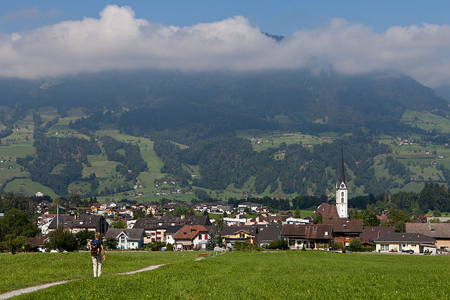
 Hiking in Innertkirchen
Innertkirchen, located in the Bernese Oberland region of Switzerland, is a fantastic destination for hiking enthusiasts. Nestled between the majestic mountains of the Alps, it offers breathtaking landscapes and a variety of trails suitable for different skill levels. Here’s what you can expect when hiking in and around Innertkirchen:
Trail Options
-
Alpenblick Trail: This moderate hike offers stunning views of the surrounding alpine landscapes. It's suitable for families and provides a perfect introduction to the area's natural beauty.
-
Kleine Scheidegg: A more challenging hike that takes you through beautiful meadows and rocky terrain. As you ascend, you'll be rewarded with magnificent views of iconic mountains such as Eiger, Mönch, and Jungfrau.
-
Aare Gorge: One of the nearby highlights, the Aare Gorge offers an impressive trail that leads you through towering limestone cliffs along the Aare River. There are well-maintained walkways and bridges, making it accessible for most hikers.
-
Gelmerbahn and Gelmer Lake: For an exhilarating experience, take the Gelmerbahn funicular to Gelmer Lake, and then enjoy hiking around the lake. The scenery is breathtaking, with turquoise waters surrounded by rugged mountains, and you can opt for longer hiking routes in the area.
What to Bring
- Appropriate Footwear: Sturdy hiking boots are essential for uneven and rocky terrain.
- Weather-Appropriate Clothing: The weather can change quickly; layers are advisable, along with rain gear.
- Water and Snacks: Stay hydrated and keep your energy levels up with snacks.
- Navigation Tools: Although trails are typically well-marked, a map or GPS device can be helpful.
Best Time to Visit
The hiking season in Innertkirchen typically runs from late May to October, depending on snowfall. Summer offers the best weather, while autumn can provide beautiful foliage.
Additional Activities
- Canyoning and Rafting: For adventure seekers, the surrounding areas offer thrilling canyoning and rafting opportunities.
- Sightseeing: Explore local attractions like the nearby waterfalls and charming Swiss villages.
Safety Tips
- Always check the weather forecast before heading out.
- Let someone know your hiking plans and expected return time.
- Be mindful of wildlife and stay on marked trails to preserve the environment.
Hiking in Innertkirchen offers a mix of natural beauty, adventure, and the warmth of Swiss culture, making it an ideal spot for both novice and experienced hikers. Enjoy your adventure!
- Country:

- Postal Code: 3862
- Local Dialing Code: 033
- Licence Plate Code: BE
- Coordinates: 46° 41' 59" N, 8° 14' 0" E


- GPS tracks (wikiloc): [Link]
- AboveSeaLevel: 625 м m
- Area: 120.0 sq km
- Population: 1076
- Web site: http://www.innertkirchen.ch
- Wikipedia en: wiki(en)
- Wikipedia: wiki(de)
- Wikidata storage: Wikidata: Q69231
- Wikipedia Commons Category: [Link]
- Freebase ID: [/m/0d4wg0]
- GeoNames ID: Alt: [2660255]
- VIAF ID: Alt: [246275700]
- OSM relation ID: [3411258]
- HDS ID: [470]
- Swiss municipality code: [0784]
Shares border with regions:


Grindelwald
- village and municipality in the canton of Bern, Switzerland
Hiking in Grindelwald
Grindelwald is a stunning alpine village located in the Bernese Oberland region of Switzerland, known for its breathtaking landscapes, towering peaks, and diverse hiking trails. Here’s what you need to know about hiking in Grindelwald:...
- Country:
- Postal Code: 3818
- Local Dialing Code: 033
- Licence Plate Code: BE
- Coordinates: 46° 37' 9" N, 8° 3' 4" E
- GPS tracks (wikiloc): [Link]
- AboveSeaLevel: 1142 м m
- Area: 171.28 sq km
- Population: 4138
- Web site: [Link]


Engelberg
- municipality in Switzerland
Hiking in Engelberg
Engelberg is a picturesque mountain village located in Switzerland, nestled in the heart of the Swiss Alps. It’s renowned for its stunning landscapes, fantastic hiking trails, and as a starting point for various outdoor activities. Here are some highlights of hiking in Engelberg:...
- Country:
- Postal Code: 6390
- Local Dialing Code: 041
- Licence Plate Code: OW
- Coordinates: 46° 49' 11" N, 8° 26' 3" E
- GPS tracks (wikiloc): [Link]
- AboveSeaLevel: 1419 м m
- Area: 40.75 sq km
- Population: 4155
- Web site: [Link]


Meiringen
- town in the canton of Bern, Switzerland
Hiking in Meiringen
Meiringen, a charming town in the Bernese Oberland region of Switzerland, is an excellent base for hikers looking to explore the stunning landscapes of the Alps. Here are some key points about hiking in Meiringen:...
- Country:
- Postal Code: 3860
- Local Dialing Code: 033
- Licence Plate Code: BE
- Coordinates: 46° 43' 42" N, 8° 11' 10" E
- GPS tracks (wikiloc): [Link]
- AboveSeaLevel: 600 м m
- Area: 40.7 sq km
- Population: 4690
- Web site: [Link]


Wolfenschiessen
- municipality in Switzerland
Hiking in Wolfenschiessen
Wolfenschiessen is a charming village located in the Nidwalden region of Switzerland, nestled between the well-known mountains of the area. It's an excellent base for hiking enthusiasts due to its stunning natural scenery, well-marked trails, and access to the surrounding alpine landscapes....
- Country:
- Postal Code: 6386
- Local Dialing Code: 041
- Licence Plate Code: NW
- Coordinates: 46° 51' 46" N, 8° 23' 40" E
- GPS tracks (wikiloc): [Link]
- AboveSeaLevel: 1516 м m
- Area: 92.76 sq km
- Population: 2093
- Web site: [Link]


Schattenhalb
- municipality in the canton of Bern, Switzerland
Hiking in Schattenhalb
Schattenhalb is a picturesque area located in the Bernese Oberland of Switzerland, renowned for its stunning landscapes and excellent hiking opportunities. Here are some key points about hiking in this region:...
- Country:
- Postal Code: 3860
- Local Dialing Code: 033
- Licence Plate Code: BE
- Coordinates: 46° 41' 39" N, 8° 10' 12" E
- GPS tracks (wikiloc): [Link]
- AboveSeaLevel: 1300 м m
- Area: 31.5 sq km
- Population: 560
- Web site: [Link]

Kerns
- village in the canton of Obwalden, Switzerland
Hiking in Kerns
Kerns is a picturesque area in Utah, known for its stunning landscapes and outdoor recreation opportunities, including hiking. Here are some key points about hiking in Kerns:...
- Country:
- Postal Code: 6064
- Local Dialing Code: 041
- Licence Plate Code: OW
- Coordinates: 46° 50' 23" N, 8° 18' 5" E
- GPS tracks (wikiloc): [Link]
- AboveSeaLevel: 1017 м m
- Area: 92.58 sq km
- Population: 6295
- Web site: [Link]


Guttannen
- municipality in Switzerland
Hiking in Guttannen
Guttannen, located in the Bernese Oberland region of Switzerland, is a small village surrounded by stunning alpine scenery. It's an excellent base for hiking enthusiasts looking to explore the natural beauty of the Swiss Alps. Here’s an overview of what you can expect when hiking in and around Guttannen:...
- Country:
- Postal Code: 3864
- Local Dialing Code: 033
- Licence Plate Code: BE
- Coordinates: 46° 38' 59" N, 8° 17' 0" E
- GPS tracks (wikiloc): [Link]
- AboveSeaLevel: 1057 м m
- Area: 200.7 sq km
- Population: 266
- Web site: [Link]


Hasliberg
- municipality in the canton of Bern, Switzerland
Hiking in Hasliberg
Hasliberg is a beautiful region located in the Bernese Oberland of Switzerland, famous for its stunning alpine landscapes and extensive network of hiking trails. Here are some key points to consider when hiking in Hasliberg:...
- Country:
- Postal Code: 6085
- Local Dialing Code: 033
- Licence Plate Code: BE
- Coordinates: 46° 44' 47" N, 8° 13' 42" E
- GPS tracks (wikiloc): [Link]
- AboveSeaLevel: 1580 м m
- Area: 41.7 sq km
- Population: 1183
- Web site: [Link]


Gadmen
- former municipality of Switzerland
Hiking in Gadmen
Gadmen is a charming village located in the canton of Bern, Switzerland, and it serves as a fantastic base for a variety of hiking adventures in the surrounding mountainous region of the Central Alps. Here are some key points about hiking in Gadmen:...
- Country:
- Postal Code: 3863
- Local Dialing Code: 033
- Licence Plate Code: BE
- Coordinates: 46° 43' 59" N, 8° 19' 59" E
- GPS tracks (wikiloc): [Link]
- AboveSeaLevel: 1205 м m
- Area: 116.4 sq km
- Web site: [Link]