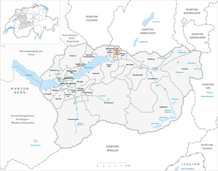
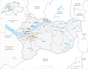
Interlaken-Oberhasli administrative district (Verwaltungskreis Interlaken-Oberhasli)

- administrative district of the canton of Bern, Switzerland (Verwaltungskreis)
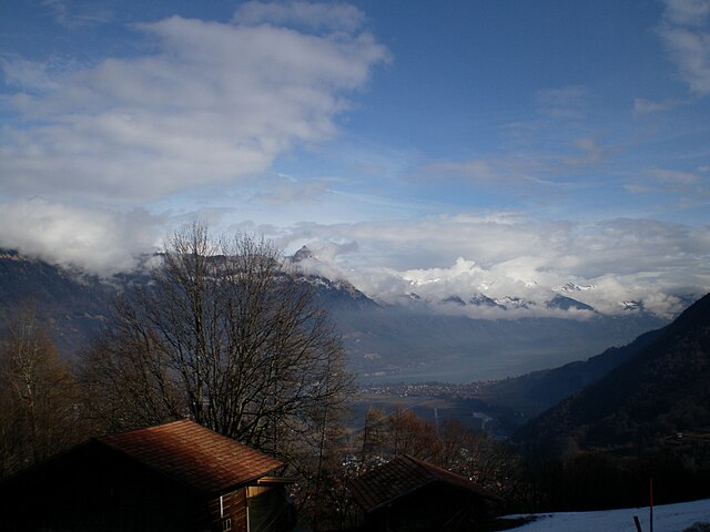
 Hiking in Interlaken-Oberhasli administrative district
Interlaken-Oberhasli is a stunning region in the Bernese Oberland of Switzerland, known for its breathtaking landscapes, towering mountains, and picturesque lakes. It offers a plethora of hiking opportunities suitable for all skill levels, from leisurely walks to challenging alpine treks. Here are some highlights and suggestions for hiking in this beautiful district:
1.
- Harder Kulm: A popular lookout point reachable by a funicular railway or by hiking. The trail offers panoramic views of the Eiger, Mönch, and Jungfrau mountains, and a breathtaking view of Interlaken and Lake Thun.
- Lauterbrunnen Valley: Known for its stunning waterfalls, this area provides several easy hiking trails that take you through lush meadows, with various viewpoints to admire the famous Staubbach Falls.
2.
- Eiger Trail: This trail along the foot of the Eiger offers amazing views of the north face of the mountain and the surrounding landscape. It's a moderately challenging trail, usually taking about 2-3 hours to complete.
- Schynige Platte to First: This hike connects two famous mountain viewpoints and includes exciting sections with panoramic views, alpine meadows, and idyllic lakes.
3.
- Aare Gorge (Aareschlucht): A family-friendly hike that takes you through a stunning gorge with impressive rock formations and the Aare River. Well-maintained pathways make it accessible for families with children.
- Trümmelbach Falls: This series of impressive waterfalls within the mountains of the Jungfrau region can be accessed via a short hike.
4.
- Grindelwald: This charming village offers an extensive network of hiking trails with varying difficulty levels. Don’t miss the hike to Bachalpsee – an easy trek with remarkable views of the surrounding peaks.
- Meiringen: Known for its connection to Sherlock Holmes, Meiringen also offers access to beautiful hikes such as the hike to the Reichenbach Falls.
5.
- Summer (June to September) is the best time for hiking with most trails open and accessible. However, be aware of weather conditions, as they can change rapidly in the mountains.
- Winter (December to March) transforms the area into a snowy wonderland, offering opportunities for snowshoeing and winter hiking. However, trails may be limited due to snow.
6.
- Always check the weather conditions before heading out and inform someone about your hiking plans.
- Carry a detailed map, water, snacks, and proper gear (hiking boots, weather-appropriate clothing).
- Be mindful of trail markings and signs, especially on more remote routes.
7.
- If you're unfamiliar with the area or would like to explore more challenging routes, consider joining a guided hiking tour. Local guides can provide insight into the ecosystems, history, and geology of the region.
Interlaken-Oberhasli offers incredible opportunities for outdoor enthusiasts, with its diverse range of hikes catering to all levels. Enjoy the stunning scenery and remember to tread lightly to preserve the natural beauty of this beautiful part of Switzerland!
- Country:

- Capital: Interlaken
- Licence Plate Code: BE
- Coordinates: 46° 40' 28" N, 8° 5' 45" E


- GPS tracks (wikiloc): [Link]
- AboveSeaLevel: 2156 м m
- Area: 1229 sq km
- Wikipedia en: wiki(en)
- Wikipedia: wiki(de)
- Wikidata storage: Wikidata: Q678742
- Wikipedia Commons Category: [Link]
- Freebase ID: [/m/0bhb7v2]
- GeoNames ID: Alt: [6458842]
- archINFORM location ID: [42770]
Includes regions:


Grindelwald
- village and municipality in the canton of Bern, Switzerland
Hiking in Grindelwald
Grindelwald is a stunning alpine village located in the Bernese Oberland region of Switzerland, known for its breathtaking landscapes, towering peaks, and diverse hiking trails. Here’s what you need to know about hiking in Grindelwald:...
- Country:
- Postal Code: 3818
- Local Dialing Code: 033
- Licence Plate Code: BE
- Coordinates: 46° 37' 9" N, 8° 3' 4" E
- GPS tracks (wikiloc): [Link]
- AboveSeaLevel: 1142 м m
- Area: 171.28 sq km
- Population: 4138
- Web site: [Link]


Lauterbrunnen
- village and municipality in the canton of Bern, Switzerland
Hiking in Lauterbrunnen
Lauterbrunnen is a stunning valley located in the Swiss Alps, known for its dramatic cliffs and impressive waterfalls. It serves as a gateway to the Jungfrau region and offers a variety of hiking opportunities, suitable for different skill levels. Here are some key highlights and tips for hiking in Lauterbrunnen:...
- Country:
- Postal Code: 3822
- Local Dialing Code: 033
- Licence Plate Code: BE
- Coordinates: 46° 33' 6" N, 7° 53' 37" E
- GPS tracks (wikiloc): [Link]
- AboveSeaLevel: 1407 м m
- Area: 164.4 sq km
- Population: 2732
- Web site: [Link]


Meiringen
- town in the canton of Bern, Switzerland
Hiking in Meiringen
Meiringen, a charming town in the Bernese Oberland region of Switzerland, is an excellent base for hikers looking to explore the stunning landscapes of the Alps. Here are some key points about hiking in Meiringen:...
- Country:
- Postal Code: 3860
- Local Dialing Code: 033
- Licence Plate Code: BE
- Coordinates: 46° 43' 42" N, 8° 11' 10" E
- GPS tracks (wikiloc): [Link]
- AboveSeaLevel: 600 м m
- Area: 40.7 sq km
- Population: 4690
- Web site: [Link]


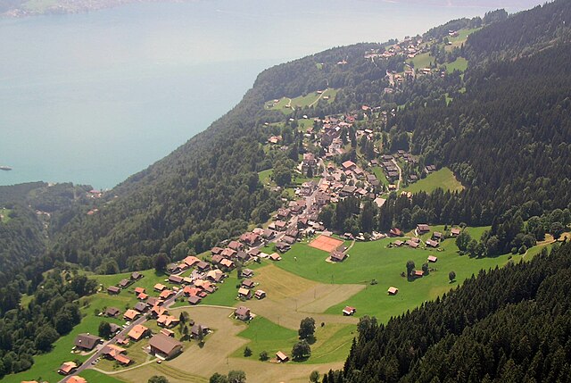
Iseltwald
- municipality in Switzerland
Hiking in Iseltwald
Iseltwald, a charming village located along the shores of Lake Brienz in Switzerland, offers a stunning backdrop for hiking enthusiasts. The area is known for its breathtaking landscapes, including pristine lake views and majestic alpine scenery. Here are some key points to consider when hiking in Iseltwald:...
- Country:
- Postal Code: 3807
- Local Dialing Code: 033
- Licence Plate Code: BE
- Coordinates: 46° 42' 35" N, 7° 57' 49" E
- GPS tracks (wikiloc): [Link]
- AboveSeaLevel: 1986 м m
- Area: 21.9 sq km
- Population: 441
- Web site: [Link]


Habkern
- municipality in Switzerland
Hiking in Habkern
Habkern is a charming village located in the Bernese Oberland region of Switzerland, surrounded by stunning alpine scenery, making it a fantastic destination for hiking enthusiasts. The area offers a variety of trails that cater to different skill levels, from easy walks to more challenging hikes....
- Country:
- Postal Code: 3804
- Local Dialing Code: 033
- Licence Plate Code: BE
- Coordinates: 46° 45' 18" N, 7° 53' 24" E
- GPS tracks (wikiloc): [Link]
- AboveSeaLevel: 1646 м m
- Area: 51.1 sq km
- Population: 643
- Web site: [Link]


Därligen
- municipality in Switzerland
Hiking in Därligen
Därligen is a charming village located near Lake Thun in the Bernese Oberland region of Switzerland. It's a fantastic area for hiking, offering stunning views of the lake and surrounding mountains, while also providing access to a variety of trails suitable for different skill levels....
- Country:
- Postal Code: 3707
- Local Dialing Code: 033
- Licence Plate Code: BE
- Coordinates: 46° 39' 12" N, 7° 48' 46" E
- GPS tracks (wikiloc): [Link]
- AboveSeaLevel: 823 м m
- Area: 6.91 sq km
- Population: 429
- Web site: [Link]

Hofstetten bei Brienz
- municipality in Switzerland
Hiking in Hofstetten bei Brienz
Hofstetten bei Brienz is a picturesque village located in the Bernese Oberland region of Switzerland, renowned for its stunning natural landscapes and outdoor activities, including hiking. Here are some highlights and recommendations for hiking in and around Hofstetten bei Brienz:...
- Country:
- Postal Code: 3858
- Local Dialing Code: 033
- Licence Plate Code: BE
- Coordinates: 46° 45' 11" N, 8° 4' 34" E
- GPS tracks (wikiloc): [Link]
- AboveSeaLevel: 646 м m
- Area: 8.7 sq km
- Population: 531
- Web site: [Link]


Brienzwiler
- municipality in Switzerland
Hiking in Brienzwiler
Brienzwiler is a picturesque village located in the Bernese Oberland region of Switzerland, nestled between Lake Brienz and the towering peaks of the Alps. It's a fantastic destination for hiking enthusiasts, offering a variety of trails that cater to different skill levels, from leisurely walks to more challenging hikes. Here are some key points to consider when hiking in and around Brienzwiler:...
- Country:
- Postal Code: 3856
- Local Dialing Code: 033
- Licence Plate Code: BE
- Coordinates: 46° 45' 5" N, 8° 6' 8" E
- GPS tracks (wikiloc): [Link]
- AboveSeaLevel: 1045 м m
- Area: 17.6 sq km
- Population: 494
- Web site: [Link]


Schwanden bei Brienz
- municipality in the canton of Bern, Switzerland
Hiking in Schwanden bei Brienz
Schwanden bei Brienz is a charming village located in the Bernese Oberland region of Switzerland, nestled on the shores of Lake Brienz. It serves as a fantastic base for various outdoor activities, including hiking. The area is surrounded by stunning landscapes, including mountains, forests, and lakes, making it a hiker's paradise....
- Country:
- Postal Code: 3855
- Local Dialing Code: 033
- Licence Plate Code: BE
- Coordinates: 46° 44' 59" N, 8° 3' 0" E
- GPS tracks (wikiloc): [Link]
- AboveSeaLevel: 659 м m
- Area: 7.02 sq km
- Population: 603
- Web site: [Link]


Brienz
- municipality in the canton of Bern, Switzerland
Hiking in Brienz
Brienz, located in the heart of Switzerland, is a beautiful destination for hiking enthusiasts. Nestled between Lake Brienz and the towering peaks of the Alps, this charming village offers a variety of hiking trails suitable for all skill levels....
- Country:
- Postal Code: 3855
- Local Dialing Code: 033
- Licence Plate Code: BE
- Coordinates: 46° 44' 59" N, 8° 2' 0" E
- GPS tracks (wikiloc): [Link]
- AboveSeaLevel: 566 м m
- Area: 48.0 sq km
- Population: 3120
- Web site: [Link]


Leissigen
- municipality in Switzerland
Hiking in Leissigen
Leissigen is a picturesque village located in the Bernese Oberland region of Switzerland, near Lake Thun. It is an excellent destination for hiking enthusiasts, offering breathtaking views of the surrounding mountains, lush forests, and tranquil lake scenery. Here are some highlights of hiking in Leissigen:...
- Country:
- Postal Code: 3706
- Local Dialing Code: 033
- Licence Plate Code: BE
- Coordinates: 46° 38' 31" N, 7° 46' 46" E
- GPS tracks (wikiloc): [Link]
- AboveSeaLevel: 1037 м m
- Area: 10.4 sq km
- Population: 1079
- Web site: [Link]


Schattenhalb
- municipality in the canton of Bern, Switzerland
Hiking in Schattenhalb
Schattenhalb is a picturesque area located in the Bernese Oberland of Switzerland, renowned for its stunning landscapes and excellent hiking opportunities. Here are some key points about hiking in this region:...
- Country:
- Postal Code: 3860
- Local Dialing Code: 033
- Licence Plate Code: BE
- Coordinates: 46° 41' 39" N, 8° 10' 12" E
- GPS tracks (wikiloc): [Link]
- AboveSeaLevel: 1300 м m
- Area: 31.5 sq km
- Population: 560
- Web site: [Link]


Bönigen
- village in the canton of Bern, Switzerland
Hiking in Bönigen
Bönigen is a picturesque village located near Interlaken in the Bernese Oberland region of Switzerland. It sits at the edge of Lake Brienz and is surrounded by stunning mountain landscapes, making it a great starting point for a variety of hiking experiences....
- Country:
- Postal Code: 3806
- Local Dialing Code: 033
- Licence Plate Code: BE
- Coordinates: 46° 41' 11" N, 7° 53' 41" E
- GPS tracks (wikiloc): [Link]
- AboveSeaLevel: 1158 м m
- Area: 15.1 sq km
- Population: 2512
- Web site: [Link]
Gündlischwand
- municipality in Switzerland
Hiking in Gündlischwand
Gündlischwand is a picturesque village located in the Bernese Oberland region of Switzerland, and it serves as a fantastic base for hiking enthusiasts. The area boasts stunning views of the surrounding mountains, lush valleys, and the iconic Eiger, Mönch, and Jungfrau peaks. Here are some highlights and tips for hiking in Gündlischwand:...
- Country:
- Postal Code: 3815
- Local Dialing Code: 033
- Licence Plate Code: BE
- Coordinates: 46° 36' 59" N, 7° 53' 59" E
- GPS tracks (wikiloc): [Link]
- AboveSeaLevel: 1551 м m
- Area: 16.9 sq km
- Population: 324
- Web site: [Link]

Gsteigwiler
- municipality in Switzerland
Hiking in Gsteigwiler
Gsteigwiler is a charming village in the Bernese Oberland region of Switzerland, near the popular tourist destination of Interlaken. This area offers breathtaking scenery, a variety of hiking trails, and access to the stunning Swiss Alps, making it an excellent destination for hikers of all levels....
- Country:
- Postal Code: 3814
- Local Dialing Code: 033
- Licence Plate Code: BE
- Coordinates: 46° 39' 8" N, 7° 53' 20" E
- GPS tracks (wikiloc): [Link]
- AboveSeaLevel: 1173 м m
- Area: 7.0 sq km
- Population: 405
- Web site: [Link]


Matten bei Interlaken
- village in the canton of Bern, Switzerland
Hiking in Matten bei Interlaken
Matten bei Interlaken is a fantastic base for hiking in the stunning Bernese Oberland region of Switzerland. Nestled between Lake Thun and Lake Brienz, it offers breathtaking views of the surrounding mountains, including the famous Eiger, Mönch, and Jungfrau....
- Country:
- Postal Code: 3800
- Local Dialing Code: 033
- Licence Plate Code: BE
- Coordinates: 46° 41' 14" N, 7° 51' 54" E
- GPS tracks (wikiloc): [Link]
- AboveSeaLevel: 571 м m
- Area: 5.9 sq km
- Population: 4071
- Web site: [Link]


Oberried am Brienzersee
- municipality in Switzerland
Hiking in Oberried am Brienzersee
Oberried am Brienzersee is a picturesque village located on the shores of Lake Brienz in Switzerland. It serves as a great base for various hiking adventures, offering stunning views of the lake and surrounding mountains. Here are some highlights and tips for hiking in this beautiful area:...
- Country:
- Postal Code: 3854
- Local Dialing Code: 033
- Licence Plate Code: BE
- Coordinates: 46° 25' 0" N, 7° 26' 59" E
- GPS tracks (wikiloc): [Link]
- AboveSeaLevel: 570 м m
- Area: 20.0 sq km
- Population: 476
- Web site: [Link]

Saxeten
- municipality in Switzerland
Hiking in Saxeten
Saxeten is a picturesque village located in the Bernese Oberland region of Switzerland, near the popular tourist town of Interlaken. It is surrounded by stunning mountainous landscapes, lush forests, and beautiful lakes, making it an excellent destination for hiking enthusiasts. Here are some key points about hiking in Saxeten:...
- Country:
- Postal Code: 3813
- Local Dialing Code: 033
- Licence Plate Code: BE
- Coordinates: 46° 37' 30" N, 7° 49' 39" E
- GPS tracks (wikiloc): [Link]
- AboveSeaLevel: 1239 м m
- Area: 19.02 sq km
- Population: 100
- Web site: [Link]


Lütschental
- municipality in Switzerland
Hiking in Lütschental
Lütschental is a picturesque valley located in the Bernese Oberland region of Switzerland, known for its stunning alpine scenery and diverse hiking opportunities. Here are some highlights and tips for hiking in Lütschental:...
- Country:
- Postal Code: 3816
- Local Dialing Code: 033
- Licence Plate Code: BE
- Coordinates: 46° 38' 38" N, 7° 57' 8" E
- GPS tracks (wikiloc): [Link]
- AboveSeaLevel: 1243 м m
- Area: 12.4 sq km
- Population: 219
- Web site: [Link]


Niederried bei Interlaken
- municipality in Switzerland
Hiking in Niederried bei Interlaken
Niederried bei Interlaken is a picturesque village located near Interlaken in Switzerland. It serves as a great starting point for a variety of hiking trails that cater to different skill levels and preferences. Here are some highlights and tips for hiking in and around Niederried:...
- Country:
- Postal Code: 3853
- Local Dialing Code: 033
- Licence Plate Code: BE
- Coordinates: 46° 42' 59" N, 7° 54' 59" E
- GPS tracks (wikiloc): [Link]
- AboveSeaLevel: 578 м m
- Area: 6.81 sq km
- Population: 348
- Web site: [Link]


Ringgenberg
- municipality in the canton of Bern, Switzerland
Hiking in Ringgenberg
Ringgenberg is a charming village located near Interlaken in the Bernese Oberland region of Switzerland. It's an excellent base for hiking enthusiasts, with stunning views of Lake Brienz, the surrounding mountains, and the iconic peaks of the Alps....
- Country:
- Postal Code: 3852
- Local Dialing Code: 033
- Licence Plate Code: BE
- Coordinates: 46° 42' 10" N, 7° 53' 42" E
- GPS tracks (wikiloc): [Link]
- AboveSeaLevel: 819 м m
- Area: 8.5 sq km
- Population: 2663
- Web site: [Link]


Unterseen
- town in the canton of Bern, Switzerland
Hiking in Unterseen
Unterseen is a charming village located near Interlaken in Switzerland, surrounded by stunning landscapes that offer a variety of hiking opportunities for all levels of outdoor enthusiasts. Here are some highlights for hiking in and around Unterseen:...
- Country:
- Postal Code: 3800
- Local Dialing Code: 033
- Licence Plate Code: BE
- Coordinates: 46° 41' 14" N, 7° 50' 59" E
- GPS tracks (wikiloc): [Link]
- AboveSeaLevel: 789 м m
- Area: 14.1 sq km
- Population: 5712
- Web site: [Link]


Interlaken
- resort town in the Swiss canton of Bern
Hiking in Interlaken
Interlaken, situated in the heart of the Swiss Alps, is a fantastic destination for hiking enthusiasts, offering stunning landscapes, a variety of trails, and breathtaking views of mountains, lakes, and valleys. Here are some highlights to consider when hiking in Interlaken:...
- Country:
- Postal Code: 3800
- Local Dialing Code: 033
- Licence Plate Code: BE
- Coordinates: 46° 41' 17" N, 7° 51' 53" E
- GPS tracks (wikiloc): [Link]
- AboveSeaLevel: 568 м m
- Area: 4.4 sq km
- Population: 5592
- Web site: [Link]

Beatenberg
- municipality in Switzerland
Hiking in Beatenberg
Beatenberg is a picturesque village located in the Swiss region of Bernese Oberland. It's renowned for its stunning panoramic views of the surrounding Alps and Lake Thun. The area is a fantastic destination for hikers of all levels, offering a variety of trails that showcase the beautiful landscapes....
- Country:
- Postal Code: 3803
- Local Dialing Code: 033
- Licence Plate Code: BE
- Coordinates: 46° 42' 53" N, 7° 48' 16" E
- GPS tracks (wikiloc): [Link]
- AboveSeaLevel: 1678 м m
- Area: 29.2 sq km
- Population: 1208
- Web site: [Link]
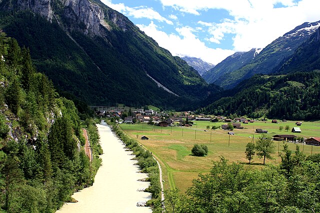

Innertkirchen
- village and municipality in the canton of Bern, Switzerland
Hiking in Innertkirchen
Innertkirchen, located in the Bernese Oberland region of Switzerland, is a fantastic destination for hiking enthusiasts. Nestled between the majestic mountains of the Alps, it offers breathtaking landscapes and a variety of trails suitable for different skill levels. Here’s what you can expect when hiking in and around Innertkirchen:...
- Country:
- Postal Code: 3862
- Local Dialing Code: 033
- Licence Plate Code: BE
- Coordinates: 46° 41' 59" N, 8° 14' 0" E
- GPS tracks (wikiloc): [Link]
- AboveSeaLevel: 625 м m
- Area: 120.0 sq km
- Population: 1076
- Web site: [Link]


Wilderswil
- village in the canton of Bern, Switzerland
Hiking in Wilderswil
Wilderswil, located in the Bernese Oberland region of Switzerland, is a charming village nestled between the stunning mountains of the Alps and is a gateway to numerous hikes. Its proximity to Interlaken makes it a popular choice for both locals and tourists seeking outdoor adventures....
- Country:
- Postal Code: 3812
- Local Dialing Code: 033
- Licence Plate Code: BE
- Coordinates: 46° 39' 59" N, 7° 52' 0" E
- GPS tracks (wikiloc): [Link]
- AboveSeaLevel: 884 м m
- Area: 13.5 sq km
- Population: 2672
- Web site: [Link]


Guttannen
- municipality in Switzerland
Hiking in Guttannen
Guttannen, located in the Bernese Oberland region of Switzerland, is a small village surrounded by stunning alpine scenery. It's an excellent base for hiking enthusiasts looking to explore the natural beauty of the Swiss Alps. Here’s an overview of what you can expect when hiking in and around Guttannen:...
- Country:
- Postal Code: 3864
- Local Dialing Code: 033
- Licence Plate Code: BE
- Coordinates: 46° 38' 59" N, 8° 17' 0" E
- GPS tracks (wikiloc): [Link]
- AboveSeaLevel: 1057 м m
- Area: 200.7 sq km
- Population: 266
- Web site: [Link]


Hasliberg
- municipality in the canton of Bern, Switzerland
Hiking in Hasliberg
Hasliberg is a beautiful region located in the Bernese Oberland of Switzerland, famous for its stunning alpine landscapes and extensive network of hiking trails. Here are some key points to consider when hiking in Hasliberg:...
- Country:
- Postal Code: 6085
- Local Dialing Code: 033
- Licence Plate Code: BE
- Coordinates: 46° 44' 47" N, 8° 13' 42" E
- GPS tracks (wikiloc): [Link]
- AboveSeaLevel: 1580 м m
- Area: 41.7 sq km
- Population: 1183
- Web site: [Link]


Gadmen
- former municipality of Switzerland
Hiking in Gadmen
Gadmen is a charming village located in the canton of Bern, Switzerland, and it serves as a fantastic base for a variety of hiking adventures in the surrounding mountainous region of the Central Alps. Here are some key points about hiking in Gadmen:...
- Country:
- Postal Code: 3863
- Local Dialing Code: 033
- Licence Plate Code: BE
- Coordinates: 46° 43' 59" N, 8° 19' 59" E
- GPS tracks (wikiloc): [Link]
- AboveSeaLevel: 1205 м m
- Area: 116.4 sq km
- Web site: [Link]