Seyssins (Seyssins)
- commune in Isère, France
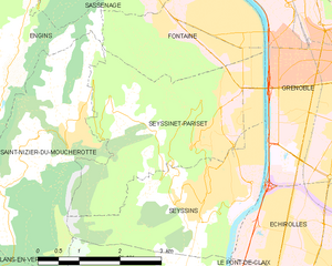
Seyssins is a picturesque town located near Grenoble in the Auvergne-Rhône-Alpes region of France. It serves as a great base for hiking enthusiasts, offering access to a variety of trails with stunning views of the surrounding mountains and valleys.
Hiking Highlights in Seyssins:
-
Proximity to the Vercors Regional Natural Park:
- Seyssins is located near the Vercors Massif, which boasts a wealth of hiking trails ranging from easy walks to challenging multi-day treks. The Vercors is known for its dramatic cliffs, limestone plateaus, and rich flora and fauna.
-
Trails:
- Sentier des Coteaux: This trail offers a beautiful walk through forests with panoramic views of Grenoble and the surrounding area. It's moderately easy and suitable for families.
- Mont Rachais: A steeper hike that rewards you with breathtaking views of the Chartreuse and Belledonne ranges. The ascent can be challenging, but the vista at the summit is well worth the climb.
- GR9 Trail: Part of the Grande Randonnée network, this trail passes through Seyssins and connects to longer routes leading into more remote wilderness areas.
-
Wildlife and Nature:
- The diverse ecosystems around Seyssins are home to various species of plants and animals. Keep an eye out for local wildlife, including deer and various bird species, particularly in the early morning or late afternoons.
-
Accessibility:
- Seyssins is easily accessible from Grenoble via public transportation or by car, making it a convenient spot for both local hikers and visitors.
-
Hiking Tips:
- Map and Compass: Always carry a map and a compass or GPS device, especially if you're venturing onto lesser-known trails.
- Weather: Check the weather conditions before heading out, as mountain weather can change rapidly.
- Gear: Wear appropriate footwear and clothing, and pack plenty of water, snacks, and a first aid kit.
-
Local Attractions:
- After a day of hiking, you can explore Seyssins itself, where you’ll find small cafés and shops to relax and enjoy the local culture.
Hiking in Seyssins offers a fantastic way to experience the natural beauty of the French Alps. Whether you're an experienced hiker or a novice, there’s something for everyone in this beautiful region. Always remember to respect nature and follow local regulations while hiking. Enjoy your adventure!
- Country:

- Postal Code: 38180
- Coordinates: 45° 9' 22" N, 5° 40' 47" E


- GPS tracks (wikiloc): [Link]
- Area: 8 sq km
- Population: 7213
- Web site: http://www.mairie-seyssins.fr
- Wikipedia en: wiki(en)
- Wikipedia: wiki(fr)
- Wikidata storage: Wikidata: Q594785
- Wikipedia Commons Category: [Link]
- Freebase ID: [/m/03g_53p]
- GeoNames ID: Alt: [6433417]
- SIREN number: [213804867]
- BnF ID: [15258290h]
- VIAF ID: Alt: [147213555]
- INSEE municipality code: 38486
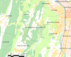
Shares border with regions:


Seyssinet-Pariset
- commune in Isère, France
Seyssinet-Pariset is a lovely commune in the Isère department, located near Grenoble in southeastern France. The region offers a variety of hiking opportunities, with beautiful landscapes that feature both mountainous terrain and lush valleys. Here are some highlights for hiking in Seyssinet-Pariset:...
- Country:

- Postal Code: 38170
- Coordinates: 45° 10' 53" N, 5° 41' 57" E


- GPS tracks (wikiloc): [Link]
- AboveSeaLevel: 262 м m
- Area: 10.65 sq km
- Population: 12264
- Web site: [Link]


Grenoble
- commune in Isère, France
Grenoble, situated at the foot of the French Alps, is an excellent base for hiking enthusiasts. The surrounding mountains and natural landscapes offer a diverse range of trails suitable for all experience levels, from leisurely walks to challenging hikes. Here are some key highlights and recommendations for hiking in the Grenoble area:...
- Country:

- Postal Code: 38100; 38000
- Local Dialing Code: 476
- Coordinates: 45° 11' 13" N, 5° 43' 35" E


- GPS tracks (wikiloc): [Link]
- AboveSeaLevel: 212 м m
- Area: 18.13 sq km
- Population: 160649
- Web site: [Link]


Échirolles
- commune in Isère, France
Échirolles is a suburb of Grenoble, located in the Auvergne-Rhône-Alpes region of France. It's surrounded by stunning natural landscapes, making it a great base for hiking enthusiasts. Here are some highlights and suggestions for hiking in and around Échirolles:...
- Country:

- Postal Code: 38130
- Coordinates: 45° 8' 34" N, 5° 43' 4" E


- GPS tracks (wikiloc): [Link]
- Area: 7.86 sq km
- Population: 35648
- Web site: [Link]


Saint-Nizier-du-Moucherotte
- commune in Isère, France
 Hiking in Saint-Nizier-du-Moucherotte
Saint-Nizier-du-Moucherotte is a picturesque village located in the French Alps, near Grenoble. It serves as an excellent starting point for various hiking trails that offer stunning views of the surrounding mountains, particularly the iconic Moucherotte peak. Here’s what you need to know about hiking in this area:...
- Country:

- Postal Code: 38250
- Coordinates: 45° 10' 15" N, 5° 37' 49" E


- GPS tracks (wikiloc): [Link]
- Area: 11.26 sq km
- Population: 1112
- Web site: [Link]


Claix
- commune in Isère, France
Claix, located in the Isère department of the Auvergne-Rhône-Alpes region of France, offers a variety of beautiful hiking opportunities due to its scenic landscapes and proximity to the French Alps. Here are some highlights and tips for hiking in and around Claix:...
- Country:

- Postal Code: 38640
- Coordinates: 45° 7' 11" N, 5° 40' 18" E


- GPS tracks (wikiloc): [Link]
- AboveSeaLevel: 300 м m
- Area: 24.12 sq km
- Population: 8018
- Web site: [Link]
