
Grenoble (Grenoble)


- commune in Isère, France
 Hiking in Grenoble
Grenoble, situated at the foot of the French Alps, is an excellent base for hiking enthusiasts. The surrounding mountains and natural landscapes offer a diverse range of trails suitable for all experience levels, from leisurely walks to challenging hikes. Here are some key highlights and recommendations for hiking in the Grenoble area:
1.
- Chartreuse Mountains: Located to the north of Grenoble, the Chartreuse Mountains provide stunning views, lush forests, and numerous trails. Notable hikes include the Dent de Crolles and Chamechaude, which is the highest peak in the range.
- Vercors Massif: This area to the south offers more rugged terrain and is known for its dramatic cliffs and diverse wildlife. Trails like Grand Veymont and the Vercors Gorges are popular among hikers.
- Belledonne Range: To the east, the Belledonne range features more challenging routes with breathtaking alpine scenery. The Pointe de la Tournette is a recommended hike for those seeking a rewarding trek.
2.
- Gréolières-les-Neiges: A moderate hike with beautiful views of the surrounding valleys and mountains.
- Lac de la Fret: An accessible trail leading to a picturesque lake, ideal for a family outing.
- Les 7 Laux: A well-known hiking circuit with multiple routes varying in difficulty and length, perfect for both beginners and seasoned hikers.
3.
- Several local maps and guidebooks are available that detail specific trails, with information on difficulty, length, and landmarks along the way.
- The Isère department’s tourist office provides updates on trail conditions, detailed maps, and additional resources.
4.
- The best months for hiking are typically from late spring to early autumn (May to October), when the weather is milder, and most trails are accessible.
- Keep in mind that conditions can vary significantly depending on elevation, so plan accordingly and check forecasts.
5.
- Ensure you have appropriate gear, including good hiking boots, clothing suited for changing weather, sufficient water, and snacks.
- Download a GPS app or carry a physical map to navigate trails easily since some areas may have limited signage.
- Inform someone about your hiking plans and expected return time, especially for longer or more remote hikes.
6.
- Grenoble is well-connected by public transport, and several buses and tram lines can take you close to various trailheads.
- For more remote hikes in the mountains, consider car rentals or checking local shuttle services.
Hiking in Grenoble offers a fantastic opportunity to connect with nature and enjoy the breathtaking Alpine scenery. Make sure to plan ahead, stay safe, and enjoy your outdoor adventure!
- Country:

- Postal Code: 38100; 38000
- Local Dialing Code: 476
- Coordinates: 45° 11' 13" N, 5° 43' 35" E


- GPS tracks (wikiloc): [Link]
- AboveSeaLevel: 212 м m
- Area: 18.13 sq km
- Population: 160649
- Web site: http://www.grenoble.fr
- Wikipedia en: wiki(en)
- Wikipedia: wiki(fr)
- Wikidata storage: Wikidata: Q1289
- Wikipedia Commons Gallery: [Link]
- Wikipedia Commons Category: [Link]
- Wikipedia Commons Maps Category: [Link]
- Freebase ID: [/m/0df_c]
- Freebase ID: [/m/0df_c]
- Freebase ID: [/m/0df_c]
- Freebase ID: [/m/0df_c]
- Freebase ID: [/m/0df_c]
- Freebase ID: [/m/0df_c]
- Freebase ID: [/m/0df_c]
- GeoNames ID: Alt: [3014728]
- GeoNames ID: Alt: [3014728]
- GeoNames ID: Alt: [3014728]
- GeoNames ID: Alt: [3014728]
- GeoNames ID: Alt: [3014728]
- GeoNames ID: Alt: [3014728]
- GeoNames ID: Alt: [3014728]
- SIREN number: [213801855]
- SIREN number: [213801855]
- SIREN number: [213801855]
- SIREN number: [213801855]
- SIREN number: [213801855]
- SIREN number: [213801855]
- SIREN number: [213801855]
- BnF ID: [119342062]
- BnF ID: [119342062]
- BnF ID: [119342062]
- BnF ID: [119342062]
- BnF ID: [119342062]
- BnF ID: [119342062]
- BnF ID: [119342062]
- VIAF ID: Alt: [265376682]
- VIAF ID: Alt: [265376682]
- VIAF ID: Alt: [265376682]
- VIAF ID: Alt: [265376682]
- VIAF ID: Alt: [265376682]
- VIAF ID: Alt: [265376682]
- VIAF ID: Alt: [265376682]
- GND ID: Alt: [4021985-9]
- GND ID: Alt: [4021985-9]
- GND ID: Alt: [4021985-9]
- GND ID: Alt: [4021985-9]
- GND ID: Alt: [4021985-9]
- GND ID: Alt: [4021985-9]
- GND ID: Alt: [4021985-9]
- archINFORM location ID: [581]
- archINFORM location ID: [581]
- archINFORM location ID: [581]
- archINFORM location ID: [581]
- archINFORM location ID: [581]
- archINFORM location ID: [581]
- archINFORM location ID: [581]
- Library of Congress authority ID: Alt: [n79091186]
- Library of Congress authority ID: Alt: [n79091186]
- Library of Congress authority ID: Alt: [n79091186]
- Library of Congress authority ID: Alt: [n79091186]
- Library of Congress authority ID: Alt: [n79091186]
- Library of Congress authority ID: Alt: [n79091186]
- Library of Congress authority ID: Alt: [n79091186]
- MusicBrainz area ID: [2ce155f8-0523-420c-82f8-0d80992f2a6e]
- MusicBrainz area ID: [2ce155f8-0523-420c-82f8-0d80992f2a6e]
- MusicBrainz area ID: [2ce155f8-0523-420c-82f8-0d80992f2a6e]
- MusicBrainz area ID: [2ce155f8-0523-420c-82f8-0d80992f2a6e]
- MusicBrainz area ID: [2ce155f8-0523-420c-82f8-0d80992f2a6e]
- MusicBrainz area ID: [2ce155f8-0523-420c-82f8-0d80992f2a6e]
- MusicBrainz area ID: [2ce155f8-0523-420c-82f8-0d80992f2a6e]
- WOEID: [593720]
- WOEID: [593720]
- WOEID: [593720]
- WOEID: [593720]
- WOEID: [593720]
- WOEID: [593720]
- WOEID: [593720]
- Quora topic ID: [Grenoble-France]
- Quora topic ID: [Grenoble-France]
- Quora topic ID: [Grenoble-France]
- Quora topic ID: [Grenoble-France]
- Quora topic ID: [Grenoble-France]
- Quora topic ID: [Grenoble-France]
- Quora topic ID: [Grenoble-France]
- SUDOC authorities ID: [026533316]
- SUDOC authorities ID: [026533316]
- SUDOC authorities ID: [026533316]
- SUDOC authorities ID: [026533316]
- SUDOC authorities ID: [026533316]
- SUDOC authorities ID: [026533316]
- SUDOC authorities ID: [026533316]
- Encyclopædia Britannica Online ID: [place/Grenoble]
- Encyclopædia Britannica Online ID: [place/Grenoble]
- Encyclopædia Britannica Online ID: [place/Grenoble]
- Encyclopædia Britannica Online ID: [place/Grenoble]
- Encyclopædia Britannica Online ID: [place/Grenoble]
- Encyclopædia Britannica Online ID: [place/Grenoble]
- Encyclopædia Britannica Online ID: [place/Grenoble]
- Gran Enciclopèdia Catalana ID: [0031110]
- Gran Enciclopèdia Catalana ID: [0031110]
- Gran Enciclopèdia Catalana ID: [0031110]
- Gran Enciclopèdia Catalana ID: [0031110]
- Gran Enciclopèdia Catalana ID: [0031110]
- Gran Enciclopèdia Catalana ID: [0031110]
- Gran Enciclopèdia Catalana ID: [0031110]
- Encyclopædia Universalis ID: [grenoble]
- Encyclopædia Universalis ID: [grenoble]
- Encyclopædia Universalis ID: [grenoble]
- Encyclopædia Universalis ID: [grenoble]
- Encyclopædia Universalis ID: [grenoble]
- Encyclopædia Universalis ID: [grenoble]
- Encyclopædia Universalis ID: [grenoble]
- HDS ID: [7357]
- HDS ID: [7357]
- HDS ID: [7357]
- HDS ID: [7357]
- HDS ID: [7357]
- HDS ID: [7357]
- HDS ID: [7357]
- EMLO location ID: [cefea5e0-1d44-4e3b-9fdc-4bfe13ac6dd5]
- EMLO location ID: [cefea5e0-1d44-4e3b-9fdc-4bfe13ac6dd5]
- EMLO location ID: [cefea5e0-1d44-4e3b-9fdc-4bfe13ac6dd5]
- EMLO location ID: [cefea5e0-1d44-4e3b-9fdc-4bfe13ac6dd5]
- EMLO location ID: [cefea5e0-1d44-4e3b-9fdc-4bfe13ac6dd5]
- EMLO location ID: [cefea5e0-1d44-4e3b-9fdc-4bfe13ac6dd5]
- EMLO location ID: [cefea5e0-1d44-4e3b-9fdc-4bfe13ac6dd5]
- Facebook Places ID: [106288792740854]
- Facebook Places ID: [106288792740854]
- Facebook Places ID: [106288792740854]
- Facebook Places ID: [106288792740854]
- Facebook Places ID: [106288792740854]
- Facebook Places ID: [106288792740854]
- Facebook Places ID: [106288792740854]
- Twitter username: Alt: [VilledeGrenoble]
- Twitter username: Alt: [VilledeGrenoble]
- Twitter username: Alt: [VilledeGrenoble]
- Twitter username: Alt: [VilledeGrenoble]
- Twitter username: Alt: [VilledeGrenoble]
- Twitter username: Alt: [VilledeGrenoble]
- Twitter username: Alt: [VilledeGrenoble]
- Great Russian Encyclopedia Online ID: [2377950]
- Great Russian Encyclopedia Online ID: [2377950]
- Great Russian Encyclopedia Online ID: [2377950]
- Great Russian Encyclopedia Online ID: [2377950]
- Great Russian Encyclopedia Online ID: [2377950]
- Great Russian Encyclopedia Online ID: [2377950]
- Great Russian Encyclopedia Online ID: [2377950]
- ISNI: Alt: [0000 0004 6038 4958]
- ISNI: Alt: [0000 0004 6038 4958]
- ISNI: Alt: [0000 0004 6038 4958]
- ISNI: Alt: [0000 0004 6038 4958]
- ISNI: Alt: [0000 0004 6038 4958]
- ISNI: Alt: [0000 0004 6038 4958]
- ISNI: Alt: [0000 0004 6038 4958]
- NKCR AUT ID: [xx0028761]
- NKCR AUT ID: [xx0028761]
- NKCR AUT ID: [xx0028761]
- NKCR AUT ID: [xx0028761]
- NKCR AUT ID: [xx0028761]
- NKCR AUT ID: [xx0028761]
- NKCR AUT ID: [xx0028761]
- data.gouv.fr org ID: [ville-de-grenoble]
- data.gouv.fr org ID: [ville-de-grenoble]
- data.gouv.fr org ID: [ville-de-grenoble]
- data.gouv.fr org ID: [ville-de-grenoble]
- data.gouv.fr org ID: [ville-de-grenoble]
- data.gouv.fr org ID: [ville-de-grenoble]
- data.gouv.fr org ID: [ville-de-grenoble]
- Petit Futé site ID: [v35259]
- Petit Futé site ID: [v35259]
- Petit Futé site ID: [v35259]
- Petit Futé site ID: [v35259]
- Petit Futé site ID: [v35259]
- Petit Futé site ID: [v35259]
- Petit Futé site ID: [v35259]
- Foursquare venue ID: [5034b5f6e4b0cc400999d28a]
- Foursquare venue ID: [5034b5f6e4b0cc400999d28a]
- Foursquare venue ID: [5034b5f6e4b0cc400999d28a]
- Foursquare venue ID: [5034b5f6e4b0cc400999d28a]
- Foursquare venue ID: [5034b5f6e4b0cc400999d28a]
- Foursquare venue ID: [5034b5f6e4b0cc400999d28a]
- Foursquare venue ID: [5034b5f6e4b0cc400999d28a]
- INSEE municipality code: 38185
- INSEE municipality code: 38185
- INSEE municipality code: 38185
- INSEE municipality code: 38185
- INSEE municipality code: 38185
- INSEE municipality code: 38185
- INSEE municipality code: 38185
- US National Archives Identifier: 10045005
- US National Archives Identifier: 10045005
- US National Archives Identifier: 10045005
- US National Archives Identifier: 10045005
- US National Archives Identifier: 10045005
- US National Archives Identifier: 10045005
- US National Archives Identifier: 10045005
Shares border with regions:


Eybens
- commune in Isère, France
Hiking in Eybens
Eybens, located near Grenoble in the Auvergne-Rhône-Alpes region of France, offers a mix of urban and natural landscapes, making it a great base for hiking enthusiasts. Here are some aspects of hiking in and around Eybens:...
- Country:
- Postal Code: 38320
- Coordinates: 45° 8' 55" N, 5° 45' 1" E
- GPS tracks (wikiloc): [Link]
- Area: 4.5 sq km
- Population: 10259
- Web site: [Link]


La Tronche
- commune in Isère, France
Hiking in La Tronche
La Tronche is a charming commune located in the Isère department of the Auvergne-Rhône-Alpes region in southeastern France, just a stone's throw from Grenoble. It is surrounded by beautiful landscapes and offers several opportunities for hiking enthusiasts. Here are some highlights and tips for hiking in and around La Tronche:...
- Country:
- Postal Code: 38700
- Coordinates: 45° 12' 23" N, 5° 44' 25" E
- GPS tracks (wikiloc): [Link]
- Area: 6.42 sq km
- Population: 6692
- Web site: [Link]


Saint-Égrève
- commune in Isère, France
Hiking in Saint-Égrève
Saint-Égrève is a commune located in the Isère department in the Auvergne-Rhône-Alpes region of southeastern France, close to the city of Grenoble. It offers a variety of hiking opportunities for outdoor enthusiasts, particularly due to its proximity to the breathtaking Chartreuse and Vercors mountains....
- Country:
- Postal Code: 38120
- Coordinates: 45° 13' 54" N, 5° 40' 59" E
- GPS tracks (wikiloc): [Link]
- AboveSeaLevel: 202 м m
- Area: 10.88 sq km
- Population: 15738
- Web site: [Link]

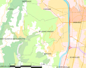
Seyssinet-Pariset
- commune in Isère, France
Hiking in Seyssinet-Pariset
Seyssinet-Pariset is a lovely commune in the Isère department, located near Grenoble in southeastern France. The region offers a variety of hiking opportunities, with beautiful landscapes that feature both mountainous terrain and lush valleys. Here are some highlights for hiking in Seyssinet-Pariset:...
- Country:
- Postal Code: 38170
- Coordinates: 45° 10' 53" N, 5° 41' 57" E
- GPS tracks (wikiloc): [Link]
- AboveSeaLevel: 262 м m
- Area: 10.65 sq km
- Population: 12264
- Web site: [Link]

Échirolles
- commune in Isère, France
Hiking in Échirolles
Échirolles is a suburb of Grenoble, located in the Auvergne-Rhône-Alpes region of France. It's surrounded by stunning natural landscapes, making it a great base for hiking enthusiasts. Here are some highlights and suggestions for hiking in and around Échirolles:...
- Country:
- Postal Code: 38130
- Coordinates: 45° 8' 34" N, 5° 43' 4" E
- GPS tracks (wikiloc): [Link]
- Area: 7.86 sq km
- Population: 35648
- Web site: [Link]


Saint-Martin-d'Hères
- commune in Isère, France
Hiking in Saint-Martin-d'Hères
Saint-Martin-d'Hères is a charming commune located near Grenoble in the Auvergne-Rhône-Alpes region of southeastern France. It offers a variety of hiking opportunities, typically set against the stunning backdrop of the surrounding mountains, particularly the Chambéranger and Chartreuse ranges....
- Country:
- Postal Code: 38400
- Coordinates: 45° 11' 1" N, 5° 45' 19" E
- GPS tracks (wikiloc): [Link]
- AboveSeaLevel: 234 м m
- Area: 9.26 sq km
- Population: 38479
- Web site: [Link]


Seyssins
- commune in Isère, France
Hiking in Seyssins
Seyssins is a picturesque town located near Grenoble in the Auvergne-Rhône-Alpes region of France. It serves as a great base for hiking enthusiasts, offering access to a variety of trails with stunning views of the surrounding mountains and valleys....
- Country:
- Postal Code: 38180
- Coordinates: 45° 9' 22" N, 5° 40' 47" E
- GPS tracks (wikiloc): [Link]
- Area: 8 sq km
- Population: 7213
- Web site: [Link]


Saint-Martin-le-Vinoux
- commune in Isère, France
Hiking in Saint-Martin-le-Vinoux
Saint-Martin-le-Vinoux is a charming commune in the Isère department of southeastern France, located near Grenoble. It offers a variety of hiking opportunities, thanks to its proximity to the stunning Vercors Regional Natural Park and the Alps....
- Country:
- Postal Code: 38950
- Coordinates: 45° 12' 11" N, 5° 42' 59" E
- GPS tracks (wikiloc): [Link]
- Area: 10.06 sq km
- Population: 5751
- Web site: [Link]

Sassenage
- commune in Isère, France
Hiking in Sassenage
Sassenage, located near the city of Grenoble in the Auvergne-Rhône-Alpes region of France, offers a variety of hiking opportunities that cater to different skill levels and interests. The region is characterized by its stunning natural landscapes, including limestone cliffs, lush forests, and panoramic views of the surrounding mountains, particularly the Vercors Massif....
- Country:
- Postal Code: 38360
- Coordinates: 45° 12' 18" N, 5° 39' 54" E
- GPS tracks (wikiloc): [Link]
- Area: 13.31 sq km
- Population: 11659
- Web site: [Link]

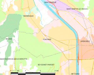
Fontaine
- commune in Isère, France
Hiking in Fontaine
Fontaine, located in the Isère department in southeastern France, is a great starting point for various hiking adventures, especially for those who enjoy the natural beauty of the Grenoble area. Here are some key highlights and tips for hiking in Fontaine:...
- Country:
- Postal Code: 38600
- Coordinates: 45° 11' 35" N, 5° 41' 5" E
- GPS tracks (wikiloc): [Link]
- AboveSeaLevel: 210 м m
- Area: 6.74 sq km
- Population: 22516
- Web site: [Link]