Seyssuel (Seyssuel)

- commune in Isère, France
- Country:

- Postal Code: 38200
- Coordinates: 45° 33' 36" N, 4° 50' 44" E


- GPS tracks (wikiloc): [Link]
- Area: 9.75 sq km
- Population: 1989
- Web site: http://www.seyssuel.fr
- Wikipedia en: wiki(en)
- Wikipedia: wiki(fr)
- Wikidata storage: Wikidata: Q1067719
- Wikipedia Commons Category: [Link]
- Freebase ID: [/m/03nvjf1]
- GeoNames ID: Alt: [2974643]
- SIREN number: [213804875]
- BnF ID: [15258291v]
- INSEE municipality code: 38487
Shares border with regions:

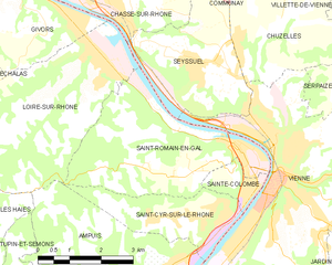
Saint-Romain-en-Gal
- commune in Rhône, France
- Country:
- Postal Code: 69560
- Coordinates: 45° 31' 57" N, 4° 51' 43" E
- GPS tracks (wikiloc): [Link]
- Area: 13.39 sq km
- Population: 1800


Communay
- commune in Rhône, France
- Country:
- Postal Code: 69360
- Coordinates: 45° 36' 16" N, 4° 50' 6" E
- GPS tracks (wikiloc): [Link]
- Area: 10.54 sq km
- Population: 4153
- Web site: [Link]


Loire-sur-Rhône
- commune in Rhône, France
- Country:
- Postal Code: 69700
- Coordinates: 45° 33' 38" N, 4° 48' 22" E
- GPS tracks (wikiloc): [Link]
- AboveSeaLevel: 157 м m
- Area: 16.6 sq km
- Population: 2549
Vienne
- commune in Isère, France
- Country:
- Postal Code: 38200
- Coordinates: 45° 31' 32" N, 4° 52' 29" E
- GPS tracks (wikiloc): [Link]
- AboveSeaLevel: 169 м m
- Area: 22.65 sq km
- Population: 29162
- Web site: [Link]


Chasse-sur-Rhône
- commune in Isère, France
- Country:
- Postal Code: 38670
- Coordinates: 45° 34' 50" N, 4° 48' 0" E
- GPS tracks (wikiloc): [Link]
- Area: 7.91 sq km
- Population: 5913
- Web site: [Link]


Chuzelles
- commune in Isère, France
- Country:
- Postal Code: 38200
- Coordinates: 45° 35' 8" N, 4° 52' 39" E
- GPS tracks (wikiloc): [Link]
- Area: 13.03 sq km
- Population: 2008
- Web site: [Link]