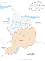
Siat (Siat)

- former municipality of Switzerland
 Hiking in Siat
Siat is a charming village located in the picturesque region of the Swiss Alps. While it may not be as well-known as some major hiking destinations in Switzerland, it offers a range of beautiful trails and outdoor experiences for those looking to explore its stunning landscapes.
Popular Hiking Trails:
-
Siat to the Latterrugia:
- A moderately challenging hike that takes you through lush forests and meadows, offering breathtaking views of the surrounding peaks. The trail often includes beautiful alpine flowers in the summer.
-
Siat to Fläsch:
- This is a great option for those looking for a less strenuous hike. The path meanders through scenic countryside, providing opportunities to spot local wildlife and enjoy the tranquility of the region.
-
Pizalun Peak:
- For the more adventurous hikers, a route leading up to Pizalun offers stunning panoramic views of the Alps. This hike requires a good level of fitness and some route finding, so it's best suited for experienced hikers.
Tips for Hiking in Siat:
-
Season: The best times to hike in Siat are during late spring through early autumn when the weather is mild, and the trails are fully accessible.
-
Gear: Make sure to wear proper hiking boots and bring essentials like water, snacks, a map, and a first aid kit. Depending on the trail, hiking poles can also be beneficial.
-
Weather: Be sure to check the weather conditions before heading out, as mountain weather can change rapidly.
-
Local Regulations: Respect the local environment and stick to marked trails to minimize your impact on nature.
Additional Activities:
- Besides hiking, Siat is an excellent location for mountain biking and wildlife photography. In the winter, the area offers opportunities for snowshoeing and skiing.
Accessibility:
Siat is reachable by public transportation from major Swiss cities, but having a car can provide more flexibility in exploring surrounding areas and more remote trails.
Whether you're a seasoned hiker or a beginner looking to enjoy the beauty of the Swiss Alps, Siat offers a peaceful and less-traveled hiking experience. Enjoy your adventure!
- Country:

- Postal Code: 7157
- Local Dialing Code: 081
- Licence Plate Code: GR
- Coordinates: 46° 46' 59" N, 9° 9' 0" E


- GPS tracks (wikiloc): [Link]
- AboveSeaLevel: 1296 м m
- Area: 13.48 sq km
- Population: 181
- Web site: http://www.siat.ch
- Wikipedia en: wiki(en)
- Wikipedia: wiki(de)
- Wikidata storage: Wikidata: Q65716
- Wikipedia Commons Category: [Link]
- Freebase ID: [/m/026gnqk]
- GeoNames ID: Alt: [8299584]
- VIAF ID: Alt: [128916704]
- OSM relation ID: [1684167]
- HDS ID: [1469]
- Swiss municipality code: [3615]
- ISNI: Alt: [0000 0001 1512 1989]
Shares border with regions:


Schnaus
- former municipality of Switzerland
Hiking in Schnaus
Schnaus, located in the Swiss region of Graubünden, is renowned for its picturesque landscapes and diverse hiking trails. While specific trail information may vary, here’s a general guide to help you enjoy hiking in this beautiful area:...
- Country:
- Postal Code: 7130
- Local Dialing Code: 081
- Licence Plate Code: GR
- Coordinates: 46° 45' 59" N, 9° 9' 59" E
- GPS tracks (wikiloc): [Link]
- AboveSeaLevel: 720 м m
- Area: 2.97 sq km


Rueun
- former municipality of Switzerland
Hiking in Rueun
Rueun is a picturesque village located in the Swiss canton of Graubünden, nestled among the stunning landscapes of the Swiss Alps. It serves as a great base for hiking enthusiasts looking to explore the natural beauty of the region. Here are some key points to know about hiking in and around Rueun:...
- Country:
- Postal Code: 7156
- Local Dialing Code: 081
- Licence Plate Code: GR
- Coordinates: 46° 45' 59" N, 9° 8' 59" E
- GPS tracks (wikiloc): [Link]
- AboveSeaLevel: 788 м m
- Area: 11.58 sq km
- Web site: [Link]


Ruschein
- former municipality of Switzerland
Hiking in Ruschein
Ruschein, located in the Grisons region of Switzerland, offers beautiful landscapes and a variety of hiking trails suitable for all levels of experience. The area is characterized by stunning alpine scenery, including lush meadows, rugged mountains, and picturesque valleys....
- Country:
- Postal Code: 7154
- Local Dialing Code: 081
- Licence Plate Code: GR
- Coordinates: 46° 46' 59" N, 9° 11' 0" E
- GPS tracks (wikiloc): [Link]
- AboveSeaLevel: 1155 м m
- Area: 12.54 sq km
- Web site: [Link]


Pigniu
- former municipality of Switzerland
Hiking in Pigniu
Pigniu is a small village located in the Swiss canton of Grisons (Graubünden), known for its stunning alpine scenery and charming landscapes. Hiking in this region offers a variety of trails that cater to different skill levels, making it a great destination for both beginners and experienced hikers....
- Country:
- Postal Code: 7156
- Local Dialing Code: 081
- Licence Plate Code: GR
- Coordinates: 46° 47' 59" N, 9° 5' 59" E
- GPS tracks (wikiloc): [Link]
- AboveSeaLevel: 1301 м m
- Area: 17.98 sq km
- Web site: [Link]

Glarus Süd
- municipality in Switzerland
Hiking in Glarus Süd
Glarus Süd, located in the canton of Glarus in Switzerland, is a fantastic destination for hiking enthusiasts. This region boasts stunning landscapes, ranging from lush valleys to rugged mountain terrains. Here are some key points about hiking in Glarus Süd:...
- Country:
- Postal Code: 8756, 8762, 8765, 8766, 8767, 8772, 8773, 8774, 8775, 8777, 8782, 8783, 8784
- Local Dialing Code: 055
- Licence Plate Code: GL
- Coordinates: 46° 59' 40" N, 9° 4' 27" E
- GPS tracks (wikiloc): [Link]
- AboveSeaLevel: 521 м m
- Area: 430.2 sq km
- Population: 9581
- Web site: [Link]