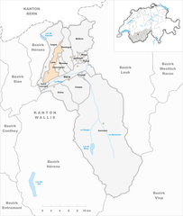
Sierre District (Bezirk Siders)

- district of the canton of Valais, Switzerland
 Hiking in Sierre District
The Sierre District is located in the Valais (Wallis) region of Switzerland, and it's known for its stunning landscapes, diverse terrain, and a variety of hiking trails suitable for all levels of hikers. Here are some key highlights about hiking in the Sierre District:
Trails and Routes
-
Val d'Anniviers: This area offers beautiful trails that connect charming villages such as Grimentz and Zinal. Hikers can enjoy picturesque views of the surrounding mountains, lush valleys, and waterfalls.
-
Barrage de Moiry: A hike to the Moiry Dam is a popular choice. You can explore the area around the dam, enjoy views of the glacier, and even venture higher for panoramic vistas.
-
Wine Trails: The region is also famous for its vineyards, particularly in the area surrounding Sierre. There are several wine hiking trails that allow hikers to sample local wines while enjoying the scenic beauty of the terraced vineyards and the Rhône Valley.
-
Mont Tsai: For those seeking a challenge, the ascent to Mont Tsai offers breathtaking views and a rewarding experience. This trail requires proper preparation, as it involves steeper climbs.
-
Bike and Hike Trails: Many trails in the area are suitable for both hiking and mountain biking, offering an exciting option for those who want to combine both activities.
Seasonal Considerations
-
Summer: During the summer months, the trails are generally well-marked and accessible. Wildflowers bloom, and the weather is usually favorable for hiking.
-
Autumn: Fall offers stunning foliage, particularly in the vineyards, making it an excellent time for photography and enjoying the colors of nature.
-
Winter: In winter, some trails are suitable for snowshoeing or winter hiking, but it's essential to check local conditions and prepare accordingly for snow and ice.
Preparation Tips
-
Gear: Always wear appropriate hiking boots and carry a backpack with enough water, snacks, a map, and first-aid supplies. Weather can change quickly, so layers are advisable.
-
Navigation: While many trails are marked, having a map or GPS device can be beneficial, especially for more remote areas.
-
Local Advice: Local tourist information centers can provide up-to-date trail conditions, maps, and insights.
Safety
- Always inform someone about your hiking plans.
- Keep an eye on the weather forecast and be prepared to turn back if conditions worsen.
- Hike within your skill level and know your physical limits.
With its breathtaking views and diverse hiking options, the Sierre District is a fantastic destination for hikers looking to experience the natural beauty of Switzerland.
- Country:

- Capital: Sierre
- Licence Plate Code: VS
- Coordinates: 46° 16' 14" N, 7° 30' 57" E


- GPS tracks (wikiloc): [Link]
- AboveSeaLevel: 515 м m
- Area: 397.0 sq km
- Wikipedia en: wiki(en)
- Wikipedia: wiki(de)
- Wikidata storage: Wikidata: Q651884
- Wikipedia Commons Category: [Link]
- Freebase ID: [/m/0286qj2]
- GeoNames ID: Alt: [6458795]
- archINFORM location ID: [45094]
- HDS ID: [8403]
- BabelNet ID: [03833685n]
Includes regions:


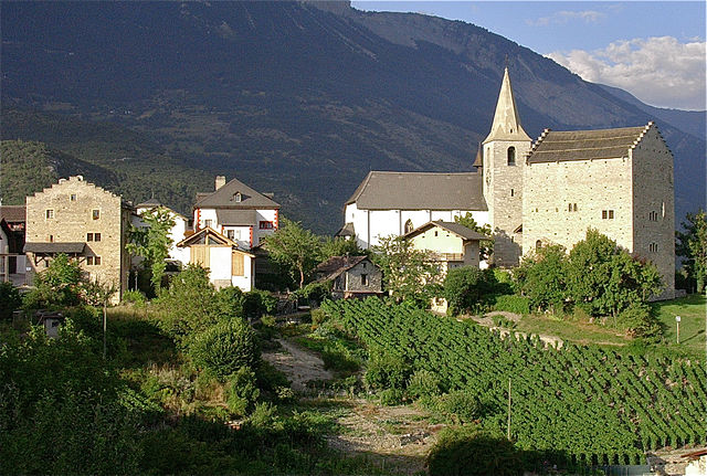
Veyras
- municipality in Switzerland
Hiking in Veyras
Veyras, a picturesque village in the Valais region of Switzerland, offers a variety of hiking opportunities that showcase its stunning landscapes, charming vineyards, and the breathtaking backdrop of the Swiss Alps. Here are some highlights and tips for hiking in and around Veyras:...
- Country:
- Postal Code: 3968
- Local Dialing Code: 027
- Licence Plate Code: VS
- Coordinates: 46° 18' 14" N, 7° 32' 33" E
- GPS tracks (wikiloc): [Link]
- AboveSeaLevel: 634 м m
- Area: 1.1 sq km
- Population: 1832
- Web site: [Link]


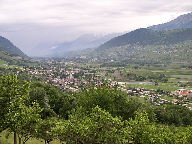
Saint-Léonard
- municipality in Switzerland
Hiking in Saint-Léonard
Saint-Léonard, located in the Valais region of Switzerland, is renowned for its stunning natural beauty and is a great destination for hiking enthusiasts. The area is characterized by its dramatic landscapes, including mountains, vineyards, and, notably, the largest underground lake in Europe, which is found in the nearby nearby region....
- Country:
- Postal Code: 1958
- Local Dialing Code: 027
- Licence Plate Code: VS
- Coordinates: 46° 15' 24" N, 7° 25' 37" E
- GPS tracks (wikiloc): [Link]
- AboveSeaLevel: 527 м m
- Area: 3.9 sq km
- Population: 2316
- Web site: [Link]


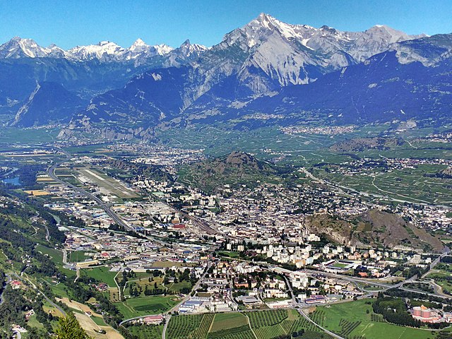
Sierre
- town in Valais, Switzerland
Hiking in Sierre
Sierre, located in the Valais region of Switzerland, is a fantastic destination for hiking enthusiasts. The area boasts stunning landscapes, from vineyards to alpine peaks, offering a variety of trails suitable for different skill levels....
- Country:
- Postal Code: 3960
- Local Dialing Code: 027
- Licence Plate Code: VS
- Coordinates: 46° 17' 30" N, 7° 31' 55" E
- GPS tracks (wikiloc): [Link]
- AboveSeaLevel: 533 м m
- Area: 1918 sq km
- Population: 16860
- Web site: [Link]
Chermignon
- municipality in Switzerland
Hiking in Chermignon
Chermignon, located in the Valais region of Switzerland, offers a beautiful setting for hiking enthusiasts. The area is known for its stunning mountain scenery, charming villages, and diverse trails suitable for various skill levels. Here are some key points to consider when hiking in Chermignon:...
- Country:
- Local Dialing Code: 027
- Licence Plate Code: VS
- Coordinates: 46° 19' 0" N, 7° 28' 0" E
- GPS tracks (wikiloc): [Link]
- AboveSeaLevel: 910 м m
- Area: 5.4 sq km
- Web site: [Link]

Icogne
- municipality in Switzerland
Hiking in Icogne
Icogne is a beautiful village located in the Valais region of Switzerland, nestled in the Swiss Alps. It offers a variety of hiking opportunities, from easy walks to more challenging trails, with stunning views of the surrounding mountains and landscapes....
- Country:
- Postal Code: 1977
- Local Dialing Code: 027
- Licence Plate Code: VS
- Coordinates: 46° 17' 0" N, 7° 26' 0" E
- GPS tracks (wikiloc): [Link]
- AboveSeaLevel: 1026 м m
- Area: 25.0 sq km
- Population: 565
- Web site: [Link]

Miège
- municipality in Switzerland
Hiking in Miège
Miège is a charming village located in the Valais region of Switzerland, known for its picturesque landscape and vibrant vineyard scenery. While it may not be as widely recognized as some of the more famous hiking destinations in Switzerland, it offers unique trails for hikers looking to explore the region's natural beauty and enjoy some tranquility....
- Country:
- Postal Code: 3972
- Local Dialing Code: 027
- Licence Plate Code: VS
- Coordinates: 46° 18' 52" N, 7° 32' 54" E
- GPS tracks (wikiloc): [Link]
- AboveSeaLevel: 737 м m
- Area: 2.5 sq km
- Population: 1348
- Web site: [Link]


Chippis
- municipality in Switzerland
Hiking in Chippis
Chippis is a lovely small municipality located in the Valais region of Switzerland. It’s known for its stunning landscapes and beautiful hiking opportunities, making it an ideal destination for outdoor enthusiasts....
- Country:
- Local Dialing Code: 027
- Licence Plate Code: VS
- Coordinates: 46° 17' 0" N, 7° 32' 0" E
- GPS tracks (wikiloc): [Link]
- AboveSeaLevel: 529 м m
- Area: 2.0 sq km
- Population: 1580
- Web site: [Link]

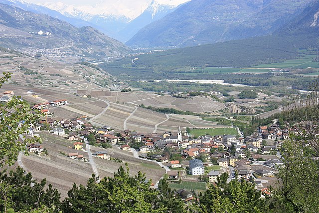
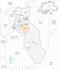
Grône
- municipality in Switzerland
Hiking in Grône
Grône is a charming municipality located in the Valais region of Switzerland, nestled between the Rhône River and the foothills of the Alps. It offers a variety of hiking opportunities that cater to different skill levels and interests. Here are some highlights of hiking in and around Grône:...
- Country:
- Postal Code: 3979
- Local Dialing Code: 027
- Licence Plate Code: VS
- Coordinates: 46° 14' 0" N, 7° 29' 11" E
- GPS tracks (wikiloc): [Link]
- AboveSeaLevel: 1742 м m
- Area: 21.1 sq km
- Population: 2411
- Web site: [Link]
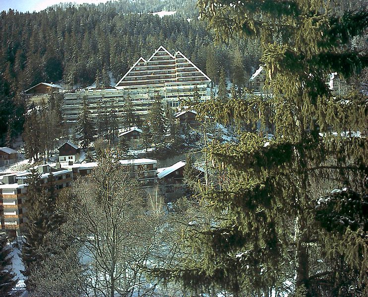

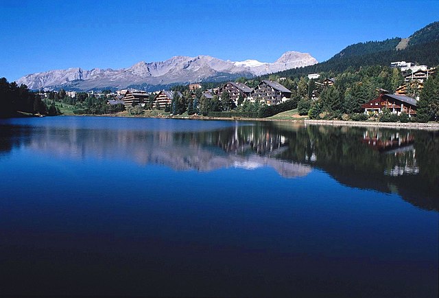
Montana
- municipality in the district of Sierre in the canton of Valais, Switzerland
Hiking in Montana
Hiking in Montana, Switzerland, offers breathtaking views and a diverse range of trails perfect for both beginners and experienced hikers. Located in the Alps, Montana is a small village in the Valais region, known for its stunning mountain scenery, picturesque landscapes, and charming atmosphere....
- Country:
- Postal Code: 3963
- Local Dialing Code: 027
- Licence Plate Code: VS
- Coordinates: 46° 19' 0" N, 7° 29' 0" E
- GPS tracks (wikiloc): [Link]
- AboveSeaLevel: 1495 м m
- Area: 4.9 sq km
- Web site: [Link]

Venthône
- municipality in Switzerland
Hiking in Venthône
Venthône, located in the Valais region of Switzerland, is known for its beautiful landscapes, picturesque villages, and stunning views of the surrounding mountains. The area offers a range of hiking opportunities suitable for different skill levels, making it a fantastic destination for both novice and experienced hikers....
- Country:
- Postal Code: 3973
- Local Dialing Code: 027
- Licence Plate Code: VS
- Coordinates: 46° 18' 0" N, 7° 32' 0" E
- GPS tracks (wikiloc): [Link]
- AboveSeaLevel: 799 м m
- Area: 2.5 sq km
- Population: 1264
- Web site: [Link]


Anniviers
- municipality in Switzerland
Hiking in Anniviers
Anniviers is a beautiful valley located in the Swiss Alps, specifically in the canton of Valais. It’s known for its stunning landscapes, charming villages, and a variety of hiking trails that cater to different skill levels. Here’s a brief overview of what to expect when hiking in Anniviers:...
- Country:
- Postal Code: 3961
- Local Dialing Code: 027
- Licence Plate Code: VS
- Coordinates: 46° 12' 0" N, 7° 35' 0" E
- GPS tracks (wikiloc): [Link]
- AboveSeaLevel: 1476 м m
- Area: 243.1 sq km
- Population: 2721
- Web site: [Link]
Mollens
- municipality in the canton of Valais, Switzerland
Hiking in Mollens
Mollens is a charming village located in the Valais region of Switzerland, offering stunning views and a range of hiking opportunities. The scenic landscapes are characterized by the majestic Alps, lush valleys, and picturesque surroundings. Here are some key points to know about hiking in Mollens:...
- Country:
- Postal Code: 3974
- Local Dialing Code: 027
- Licence Plate Code: VS
- Coordinates: 46° 21' 1" N, 7° 32' 17" E
- GPS tracks (wikiloc): [Link]
- AboveSeaLevel: 1905 м m
- Area: 11.1 sq km
- Web site: [Link]
Randogne
- municipality in Switzerland
Hiking in Randogne
Randogne is a beautiful region located in the Valais canton of Switzerland, near the popular resort town of Crans-Montana. It's known for its stunning landscapes, diverse hiking trails, and charming alpine villages. Here are some key points to consider if you're planning to hike in Randogne:...
- Country:
- Postal Code: 3975
- Local Dialing Code: 027
- Licence Plate Code: VS
- Coordinates: 46° 19' 0" N, 7° 31' 0" E
- GPS tracks (wikiloc): [Link]
- AboveSeaLevel: 1468 м m
- Area: 16.8 sq km
- Web site: [Link]

Lens
- municipality in Switzerland
Hiking in Lens
Lens, Switzerland, is a charming village located in the Valais region, close to the popular resort town of Crans-Montana. The area is renowned for its stunning alpine scenery, diverse flora and fauna, and a variety of hiking trails suitable for all levels of hikers. Here are some highlights for hiking in and around Lens:...
- Country:
- Postal Code: 1978
- Local Dialing Code: 027
- Licence Plate Code: VS
- Coordinates: 46° 16' 0" N, 7° 26' 0" E
- GPS tracks (wikiloc): [Link]
- AboveSeaLevel: 1134 м m
- Area: 13.9 sq km
- Population: 4162
- Web site: [Link]
Chalais
- municipality in Switzerland
Hiking in Chalais
Chalais is a picturesque village located in the Valais region of Switzerland, nestled in the heart of the Alps. It's a fantastic destination for hiking enthusiasts, offering a variety of trails that cater to different skill levels and preferences....
- Country:
- Local Dialing Code: 027
- Licence Plate Code: VS
- Coordinates: 46° 14' 52" N, 7° 31' 49" E
- GPS tracks (wikiloc): [Link]
- AboveSeaLevel: 1605 м m
- Area: 24.5 sq km
- Population: 3528
- Web site: [Link]
Shares border with regions:

Sion District
- district of the canton of Valais, Switzerland
Hiking in Sion District
The Sion District, located in the heart of Switzerland's Valais canton, is a wonderful destination for hiking enthusiasts. Known for its stunning alpine landscapes, charming villages, and rich cultural heritage, the Sion District offers a variety of hiking trails suitable for different skill levels....
- Country:
- Capital: Sion
- Licence Plate Code: VS
- Coordinates: 46° 14' 0" N, 7° 20' 58" E
- GPS tracks (wikiloc): [Link]
- AboveSeaLevel: 548 м m
- Area: 125.6 sq km


Hérens District
- district of the canton of Valais, Switzerland
Hiking in Hérens District
The Hérens District, located in the Valais Canton of Switzerland, is known for its stunning landscapes, diverse terrain, and rich cultural heritage, making it a fantastic destination for hiking enthusiasts. Here are some key points to consider when hiking in the Hérens District:...
- Country:
- Capital: Vex
- Licence Plate Code: VS
- Coordinates: 46° 11' 38" N, 7° 25' 26" E
- GPS tracks (wikiloc): [Link]
- AboveSeaLevel: 1098 м m
- Area: 443.5 sq km


Visp District
- district of the canton of Valais, Switzerland
Hiking in Visp District
The Visp District, located in the Valais canton of Switzerland, is an excellent destination for hiking enthusiasts. Surrounded by stunning Alpine scenery, it offers a variety of trails suitable for different skill levels, from beginners to experienced hikers. Here are some highlights and key points regarding hiking in the Visp District:...
- Country:
- Capital: Visp
- Licence Plate Code: VS
- Coordinates: 46° 17' 0" N, 7° 52' 0" E
- GPS tracks (wikiloc): [Link]
- AboveSeaLevel: 2758 м m
- Area: 863.8 sq km


Leuk District
- district of the canton of Valais, Switzerland
Hiking in Leuk District
The Leuk District, located in the Valais canton of Switzerland, is a stunning hiking destination known for its diverse landscapes, charming villages, and a variety of trails suitable for all skill levels. Here are some key highlights to consider when planning a hiking trip in this region:...
- Country:
- Capital: Leuk
- Licence Plate Code: VS
- Coordinates: 46° 19' 5" N, 7° 38' 4" E
- GPS tracks (wikiloc): [Link]
- AboveSeaLevel: 957 м m
- Area: 335.9 sq km