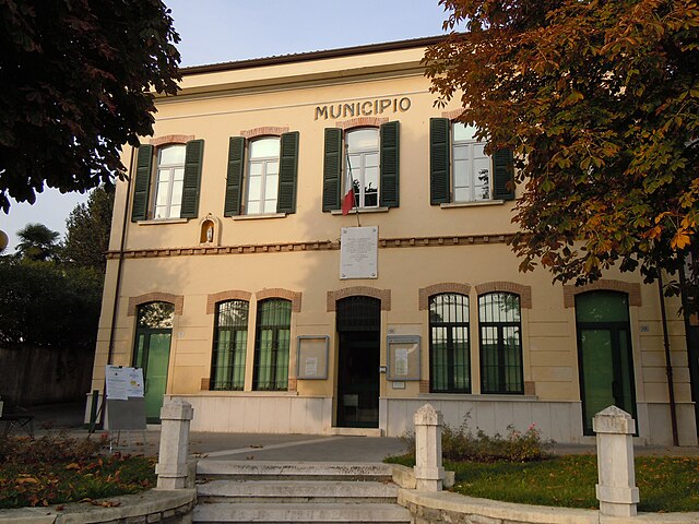
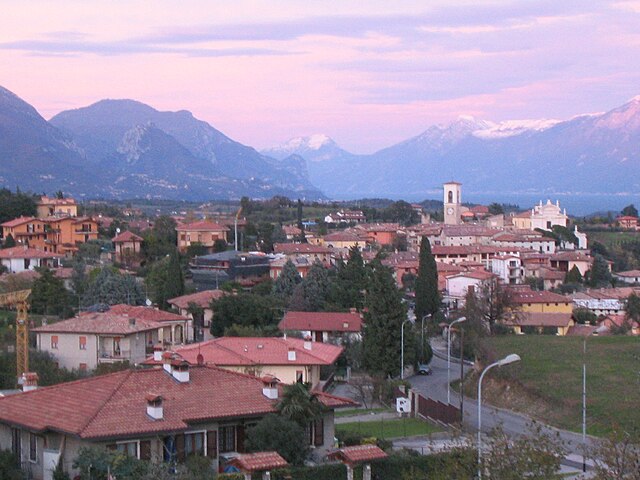
Soiano del Lago (Soiano del Lago)
.svg)
- Italian comune
 Hiking in Soiano del Lago
Soiano del Lago, located in the Lombardy region of Italy, near Lake Garda, offers a variety of hiking opportunities that showcase the area's stunning natural beauty and cultural heritage. The region is characterized by its rolling hills, olive groves, and panoramic views of the lake, making it a picturesque destination for hikers of all levels.
Hiking Trails
-
Sentiero del Castello (Castle Trail):
- This trail often leads to the ruins of the nearby castle, offering both a historical perspective and beautiful views of Lake Garda. The path is generally well-marked and can be suitable for families.
-
Lovere to Soiano Loop:
- A longer circular trail that connects Soiano with nearby villages and offers sections that pass through vineyards and olive orchards. The elevation changes provide a great workout and rewarding vistas.
-
Montinelle Ridge:
- This trail provides a more rugged experience with steeper sections and is ideal for experienced hikers. The ridge offers breathtaking views of the lake from various vantage points.
Tips for Hiking in Soiano del Lago
- Best Time to Go: Spring (April to June) and early fall (September to October) offer mild weather and fewer crowds. Summer can be hot, so hike early in the morning or later in the afternoon.
- What to Bring: Good hiking boots, plenty of water (especially in warmer months), sun protection, snacks, and a map or GPS device.
- Local Regulations: Respect local wildlife and plants, stay on designated trails to prevent erosion, and follow any guidelines set by local authorities.
Nearby Attractions
- Lake Garda: After your hike, take time to relax by the lake, go for a swim, or explore the charming nearby towns such as Salò or Gardone Riviera.
- Cultural Sites: Check out the local churches and historical sites in Soiano, which add a cultural dimension to your hiking experience.
In summary, hiking in Soiano del Lago combines scenic trails, historical exploration, and the beauty of Lake Garda, making it a perfect destination for outdoor enthusiasts. Always be prepared, respect the environment, and enjoy the breathtaking views!
- Country:

- Postal Code: 25080
- Local Dialing Code: 0365
- Licence Plate Code: BS
- Coordinates: 45° 31' 40" N, 10° 30' 46" E


- GPS tracks (wikiloc): [Link]
- AboveSeaLevel: 196 м m
- Area: 5.77 sq km
- Population: 1919
- Web site: http://www.comune.soianodellago.bs.it/
- Wikipedia en: wiki(en)
- Wikipedia: wiki(it)
- Wikidata storage: Wikidata: Q112022
- Wikipedia Commons Category: [Link]
- Freebase ID: [/m/04d33_]
- GeoNames ID: Alt: [6542795]
- VIAF ID: Alt: [155003446]
- OSM relation ID: [45227]
- Library of Congress authority ID: Alt: [n2009017103]
- UN/LOCODE: [ITSDL]
- ISTAT ID: 017180
- Italian cadastre code: I782
Shares border with regions:
Calvagese della Riviera
- Italian comune
Hiking in Calvagese della Riviera
Calvagese della Riviera, located in the province of Brescia in Northern Italy, offers various hiking opportunities that allow you to explore its picturesque landscapes and natural beauty. Here are some key points to consider when hiking in this area:...
- Country:
- Postal Code: 25080
- Local Dialing Code: 030
- Licence Plate Code: BS
- Coordinates: 45° 32' 3" N, 10° 26' 33" E
- GPS tracks (wikiloc): [Link]
- AboveSeaLevel: 225 м m
- Area: 11.74 sq km
- Population: 3566
- Web site: [Link]

Manerba del Garda
- Italian comune
Hiking in Manerba del Garda
Manerba del Garda is a beautiful area located on the western shore of Lake Garda in northern Italy. The region is known for its stunning natural scenery, rich history, and a variety of hiking paths that cater to different skill levels. Here are some key highlights and tips for hiking in Manerba del Garda:...
- Country:
- Postal Code: 25080
- Local Dialing Code: 0365
- Licence Plate Code: BS
- Coordinates: 45° 32' 59" N, 10° 33' 5" E
- GPS tracks (wikiloc): [Link]
- AboveSeaLevel: 130 м m
- Area: 36.63 sq km
- Population: 5357
- Web site: [Link]

Moniga del Garda
- Italian comune
Hiking in Moniga del Garda
Moniga del Garda is a charming town located on the western shore of Lake Garda in Italy. It offers beautiful scenery, lovely views of the lake, and a pleasant Mediterranean climate, making it a great destination for hiking enthusiasts. Here are some details about hiking in the area:...
- Country:
- Postal Code: 25080
- Local Dialing Code: 0365
- Licence Plate Code: BS
- Coordinates: 45° 31' 37" N, 10° 32' 20" E
- GPS tracks (wikiloc): [Link]
- AboveSeaLevel: 125 м m
- Area: 14.65 sq km
- Population: 2575
- Web site: [Link]

Padenghe sul Garda
- Italian comune
Hiking in Padenghe sul Garda
Padenghe sul Garda, located on the southwestern shore of Lake Garda in Italy, offers a beautiful backdrop for hiking enthusiasts. The area is characterized by its stunning lake views, rolling hills, olive groves, and vineyards. Here’s what you can expect when hiking in and around Padenghe sul Garda:...
- Country:
- Postal Code: 25080
- Local Dialing Code: 030
- Licence Plate Code: BS
- Coordinates: 45° 30' 30" N, 10° 30' 59" E
- GPS tracks (wikiloc): [Link]
- AboveSeaLevel: 127 м m
- Area: 26.81 sq km
- Population: 4629
- Web site: [Link]
Polpenazze del Garda
- Italian comune
Hiking in Polpenazze del Garda
Polpenazze del Garda, located in the province of Brescia in northern Italy, offers a charming hiking experience with stunning views of Lake Garda and the surrounding countryside. This quaint town is part of the Valtènesi area, known for its vineyards, olive groves, and hilly landscapes, making it a perfect destination for both novice and experienced hikers....
- Country:
- Postal Code: 25080
- Local Dialing Code: 0365
- Licence Plate Code: BS
- Coordinates: 45° 32' 41" N, 10° 30' 51" E
- GPS tracks (wikiloc): [Link]
- AboveSeaLevel: 204 м m
- Area: 9.12 sq km
- Population: 2672
- Web site: [Link]