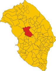
Soleto (Soleto)
.svg)
- Italian comune
 Hiking in Soleto
Soleto is a charming town located in the Apulia region of southern Italy, known for its rich history, beautiful architecture, and surrounding natural landscape. Hiking in and around Soleto can offer a blend of cultural experiences and scenic beauty.
Hiking Opportunities around Soleto
-
Local Trails: There are several trails around Soleto that lead through olive groves, vineyards, and historical sites. You might encounter charming rural landscapes and traditional dry stone walls typical of the region.
-
Cava di Bauxite: A short drive north of Soleto leads you to the Cava di Bauxite near the town of Otranto. This former bauxite quarry is known for its striking red and green cliffs and waters, providing opportunities for short hikes with breathtaking views.
-
Natural Parks: The nearby Leuca - Santa Maria di Leuca Natural Park and the Regional Park of Porto Selvaggio and Palude del Capitano offer diverse terrains—from coastal paths to wooded areas—making it an excellent spot for hiking, bird watching, and enjoying nature.
-
Historic Routes: Tracing routes that connect Soleto to other historical towns like Galatina and Gallipoli can also be rewarding. These paths often lead through ancient sites and pastoral landscapes.
Tips for Hiking in Soleto
- Best Time to Hike: Spring (April to June) and fall (September to October) are ideal, as temperatures are milder and the landscape is lush.
- Gear Up: Wear sturdy hiking shoes, and don’t forget to bring water, sunscreen, and snacks, especially during warmer months.
- Respect the Environment: Stay on marked trails to preserve the natural habitat and respect local wildlife.
- Local Guidance: Consider hiring a local guide if you're unfamiliar with the area. They can enhance your experience with insights about the landscape and history.
Cultural Experience
Hiking in Soleto not only allows for physical activity but also immerses you in the local culture. The town is known for its local cuisine, including traditional Puglian dishes, so be sure to plan for some culinary exploration after your hikes.
Whether you're a novice or an experienced hiker, Soleto and its surroundings offer something special for every nature enthusiast. Happy hiking!
- Country:

- Postal Code: 73010
- Local Dialing Code: 0836
- Licence Plate Code: LE
- Coordinates: 40° 11' 16" N, 18° 12' 26" E


- GPS tracks (wikiloc): [Link]
- AboveSeaLevel: 91 м m
- Area: 30.46 sq km
- Population: 5422
- Web site: http://www.comune.soleto.le.it/
- Wikipedia en: wiki(en)
- Wikipedia: wiki(it)
- Wikidata storage: Wikidata: Q52197
- Wikipedia Commons Category: [Link]
- Wikipedia Commons Maps Category: [Link]
- Freebase ID: [/m/03wkhr]
- GeoNames ID: Alt: [6538986]
- VIAF ID: Alt: [154924077]
- OSM relation ID: [40331]
- GND ID: Alt: [4342802-2]
- WOEID: [724297]
- UN/LOCODE: [ITSOE]
- Digital Atlas of the Roman Empire ID: [30409]
- ISTAT ID: 075076
- Italian cadastre code: I800
Shares border with regions:


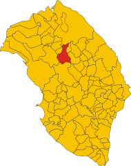
Corigliano d'Otranto
- Italian comune
Hiking in Corigliano d'Otranto
Corigliano d'Otranto, located in the province of Lecce in the Apulia region of Italy, offers a charming landscape that is perfect for hiking enthusiasts. While it may not be the first location that comes to mind for hiking, it does have unique features that attract nature lovers and adventurers alike....
- Country:
- Postal Code: 73022
- Local Dialing Code: 0836
- Licence Plate Code: LE
- Coordinates: 40° 10' 0" N, 18° 15' 0" E
- GPS tracks (wikiloc): [Link]
- AboveSeaLevel: 76 м m
- Area: 28.41 sq km
- Population: 5768
- Web site: [Link]

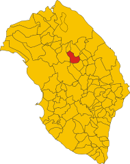
Galatina
- Italian comune
Hiking in Galatina
Galatina, a charming town located in the Puglia region of southern Italy, is not primarily known as a hiking destination. However, it serves as a great base for exploring the surrounding countryside and coastal areas. Here are some aspects of hiking in and around Galatina:...
- Country:
- Postal Code: 73013
- Local Dialing Code: 0836
- Licence Plate Code: LE
- Coordinates: 40° 10' 0" N, 18° 10' 0" E
- GPS tracks (wikiloc): [Link]
- AboveSeaLevel: 78 м m
- Area: 82.65 sq km
- Population: 26887
- Web site: [Link]

Lequile
- Italian comune
Hiking in Lequile
Lequile, a charming town in the Apulia region of Italy, is not as well-known for hiking as some of the more mountainous areas of the country, but it offers an opportunity to explore the beautiful landscapes of the Salento peninsula nearby. While there may not be extensive hiking trails directly within Lequile, you can find several options within a short drive....
- Country:
- Postal Code: 73010
- Local Dialing Code: 0832
- Licence Plate Code: LE
- Coordinates: 40° 18' 0" N, 18° 8' 0" E
- GPS tracks (wikiloc): [Link]
- AboveSeaLevel: 38 м m
- Area: 36.8 sq km
- Population: 8689
- Web site: [Link]
San Donato di Lecce
- Italian comune
Hiking in San Donato di Lecce
San Donato di Lecce, located in the Apulia region of Italy, is a charming town that offers a great opportunity for hiking enthusiasts to explore the beautiful countryside and historical sites of the area. Here are some key points to consider if you're planning a hiking trip in and around San Donato di Lecce:...
- Country:
- Postal Code: 73010
- Local Dialing Code: 0832
- Licence Plate Code: LE
- Coordinates: 40° 16' 0" N, 18° 11' 0" E
- GPS tracks (wikiloc): [Link]
- AboveSeaLevel: 70 м m
- Area: 21.58 sq km
- Population: 5656
- Web site: [Link]


Sternatia
- Italian comune
Hiking in Sternatia
Sternatia, located in the Salento region of Italy, is a charming town that makes for an excellent base for hiking enthusiasts looking to explore the diverse landscapes and natural beauty of the area. While Sternatia itself may not be known specifically for its hiking trails, the surrounding region offers a variety of options....
- Country:
- Postal Code: 73010
- Local Dialing Code: 0836
- Licence Plate Code: LE
- Coordinates: 40° 13' 0" N, 18° 14' 0" E
- GPS tracks (wikiloc): [Link]
- AboveSeaLevel: 73 м m
- Area: 16.76 sq km
- Population: 2261
- Web site: [Link]
Zollino
- Italian comune
Hiking in Zollino
Zollino, a charming town located in the Apulia region of southern Italy, offers a unique experience for hikers looking to explore natural landscapes and cultural heritage. Here are some key points about hiking in and around Zollino:...
- Country:
- Postal Code: 73010
- Local Dialing Code: 0836
- Licence Plate Code: LE
- Coordinates: 40° 12' 0" N, 18° 15' 0" E
- GPS tracks (wikiloc): [Link]
- AboveSeaLevel: 90 м m
- Area: 9.95 sq km
- Population: 1961
- Web site: [Link]