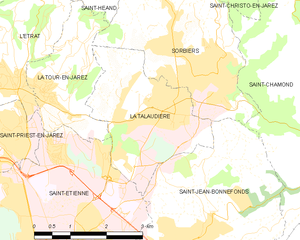
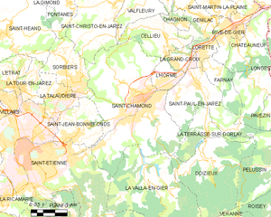
Sorbiers (Sorbiers)

- commune in Loire, France
- Country:

- Postal Code: 42290
- Coordinates: 45° 29' 16" N, 4° 27' 1" E


- GPS tracks (wikiloc): [Link]
- Area: 12.19 sq km
- Population: 8083
- Web site: http://www.mairie-sorbiers.fr/
- Wikipedia en: wiki(en)
- Wikipedia: wiki(fr)
- Wikidata storage: Wikidata: Q1069995
- Wikipedia Commons Category: [Link]
- Freebase ID: [/m/03qd3pd]
- Freebase ID: [/m/03qd3pd]
- GeoNames ID: Alt: [6434328]
- GeoNames ID: Alt: [6434328]
- SIREN number: [214203028]
- SIREN number: [214203028]
- BnF ID: [152598687]
- BnF ID: [152598687]
- INSEE municipality code: 42302
- INSEE municipality code: 42302
Shares border with regions:


Fontanès
- commune in Loire, France
- Country:
- Postal Code: 42140
- Coordinates: 45° 32' 48" N, 4° 26' 14" E
- GPS tracks (wikiloc): [Link]
- Area: 6.63 sq km
- Population: 673


Saint-Jean-Bonnefonds
- commune in Loire, France
- Country:
- Postal Code: 42650
- Coordinates: 45° 27' 4" N, 4° 26' 47" E
- GPS tracks (wikiloc): [Link]
- Area: 11.59 sq km
- Population: 6680
- Web site: [Link]


La Tour-en-Jarez
- commune in Loire, France
- Country:
- Postal Code: 42580
- Coordinates: 45° 29' 7" N, 4° 23' 19" E
- GPS tracks (wikiloc): [Link]
- Area: 5.05 sq km
- Population: 1461
- Web site: [Link]


Saint-Héand
- commune in Loire, France
- Country:
- Postal Code: 42570
- Coordinates: 45° 31' 43" N, 4° 22' 22" E
- GPS tracks (wikiloc): [Link]
- Area: 31.3 sq km
- Population: 3600
- Web site: [Link]


Saint-Christo-en-Jarez
- commune in Loire, France
- Country:
- Postal Code: 42320
- Coordinates: 45° 32' 41" N, 4° 29' 12" E
- GPS tracks (wikiloc): [Link]
- Area: 21.77 sq km
- Population: 1828
- Web site: [Link]

La Talaudière
- commune in Loire, France
- Country:
- Postal Code: 42350
- Coordinates: 45° 28' 53" N, 4° 25' 55" E
- GPS tracks (wikiloc): [Link]
- Area: 7.63 sq km
- Population: 6608
- Web site: [Link]

Saint-Chamond
- commune in Loire, France
- Country:
- Postal Code: 42400
- Coordinates: 45° 28' 35" N, 4° 30' 53" E
- GPS tracks (wikiloc): [Link]
- AboveSeaLevel: 375 м m
- Area: 54.88 sq km
- Population: 34870
- Web site: [Link]