.jpg)
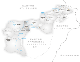
St. Gallen (St. Gallen)

- capital of St. Gallen canton in Switzerland
 Hiking in St. Gallen
St. Gallen, located in the northeastern part of Switzerland, is an excellent destination for hiking enthusiasts. The region is characterized by stunning landscapes, including rolling hills, lush forests, and panoramic mountain views. Here are some highlights of hiking in and around St. Gallen:
Trails and Routes
-
Pizol: This mountain offers several hiking trails, including the Pizol Panorama Trail, which showcases breathtaking views of the surrounding peaks and alpine lakes. The hike to the Pizol Glacier is another popular option.
-
Säntis: As the highest peak in the Alpstein massif, Säntis provides a challenging hike with rewarding views. The trail from Schwägalp to the summit of Säntis is well-marked and features a cable car for those who want a less strenuous ascent.
-
Appenzellerland: Just a short distance from St. Gallen, this area features scenic trails that take hikers through traditional Swiss villages, rolling pastures, and stunning landscapes. The "Appenzeller Trail" can be a particularly enjoyable experience for its cultural insights and beautiful scenery.
-
Waldstatt to Eppenberg: This lesser-known route offers a more tranquil hiking experience through forests and meadows, with great opportunities for wildlife watching.
Key Features
- Accessibility: Many trails are easily accessible via public transportation or short drives from the city center.
- Scenery: Hikers can enjoy diverse landscapes ranging from lush valleys to rocky mountain terrain, including picturesque lakes and rivers.
- Flora and Fauna: The region is rich in biodiversity, with opportunities to see various plants and wildlife, especially during the spring and summer months.
Tips for Hiking in St. Gallen
- Weather: Always check the weather conditions before heading out, as mountain weather can change rapidly.
- Preparation: Bring adequate gear, including sturdy footwear, weather-appropriate clothing, and enough water and snacks.
- Trail Information: Make use of local tourism websites or app-based guides to get the latest updates on trail conditions and difficulty levels.
Local Resources
- Tourist Information Centers: They provide maps, advice on trails, and can suggest guided hikes.
- Guided Tours: For those unfamiliar with the area, consider joining a guided hike to explore hidden gems and learn about local flora, fauna, and history.
St. Gallen offers a fantastic blend of cultural and natural experiences for hikers of all levels. Whether you seek challenging trails or leisurely walks, you'll find plenty of options to explore the beauty of this Swiss region.
- Country:

- Postal Code: 9000
- Local Dialing Code: 071
- Licence Plate Code: SG
- Coordinates: 47° 25' 24" N, 9° 22' 38" E


- GPS tracks (wikiloc): [Link]
- AboveSeaLevel: 675 м m
- Area: 39.41 sq km
- Population: 75481
- Web site: http://www.stadt.sg.ch
- Wikipedia en: wiki(en)
- Wikipedia: wiki(de)
- Wikidata storage: Wikidata: Q25607
- Wikipedia Commons Gallery: [Link]
- Wikipedia Commons Category: [Link]
- Wikipedia Commons Maps Category: [Link]
- Freebase ID: [/m/0245n9]
- GeoNames ID: Alt: [7287240]
- BnF ID: [11950003x]
- VIAF ID: Alt: [127834916]
- OSM relation ID: [1683941]
- GND ID: Alt: [4051594-1]
- archINFORM location ID: [1568]
- Library of Congress authority ID: Alt: [n80004388]
- MusicBrainz area ID: [bdf2dee3-e43c-47a2-8b27-0bf29c3c91c2]
- Quora topic ID: [St-Gallen-Switzerland]
- Encyclopædia Britannica Online ID: [place/Sankt-Gallen-Switzerland]
- Gran Enciclopèdia Catalana ID: [0058746]
- HDS ID: [1321]
- EMLO location ID: [1d0548c2-8d3d-4d0e-ad5a-d5cc3dd9cf4e]
- Facebook Places ID: [110759738952928]
- Swiss municipality code: [3203]
- ISNI: Alt: [0000 0001 2321 910X]
- BNE ID: Alt: [XX454270]
- NLA (Australia) ID: [36585741]
Shares border with regions:


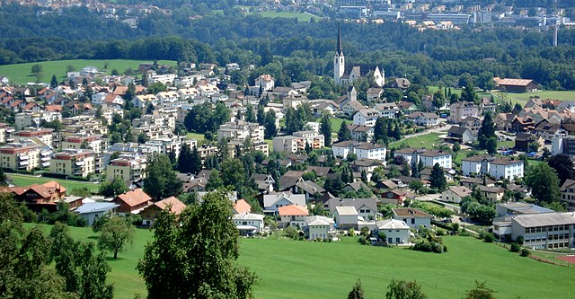
Herisau
- municipality in Switzerland
Hiking in Herisau
Herisau is a charming village located in the Appenzell region of Switzerland, surrounded by picturesque landscapes and rolling hills. It's an excellent destination for hiking enthusiasts, offering a variety of trails suitable for different skill levels. Here are some highlights of hiking in Herisau:...
- Country:
- Postal Code: 9100
- Local Dialing Code: 071
- Licence Plate Code: AR
- Coordinates: 47° 23' 6" N, 9° 16' 43" E
- GPS tracks (wikiloc): [Link]
- AboveSeaLevel: 738 м m
- Area: 25.2 sq km
- Population: 15780
- Web site: [Link]


Wittenbach
- municipality in the canton of St. Gallen, Switzerland
Hiking in Wittenbach
Wittenbach is a beautiful area for hiking, located in the canton of St. Gallen in Switzerland. The region offers a mix of lush landscapes, scenic views, and well-marked trails that can cater to various skill levels. Here are some key points to consider if you're planning a hiking trip in Wittenbach:...
- Country:
- Postal Code: 9300
- Local Dialing Code: 071
- Licence Plate Code: SG
- Coordinates: 47° 28' 0" N, 9° 22' 46" E
- GPS tracks (wikiloc): [Link]
- AboveSeaLevel: 588 м m
- Area: 12.22 sq km
- Population: 9784
- Web site: [Link]


Mörschwil
- municipality in Switzerland
Hiking in Mörschwil
Mörschwil is a charming municipality located in the canton of St. Gallen, Switzerland. With its picturesque landscapes and proximity to Lake Constance, it offers a variety of hiking opportunities that cater to different skill levels and preferences. Here are some highlights:...
- Country:
- Postal Code: 9402
- Local Dialing Code: 071
- Licence Plate Code: SG
- Coordinates: 47° 28' 3" N, 9° 25' 34" E
- GPS tracks (wikiloc): [Link]
- AboveSeaLevel: 551 м m
- Area: 9.83 sq km
- Population: 3583
- Web site: [Link]


Untereggen
- municipality in Switzerland
Hiking in Untereggen
Untereggen, located in Switzerland, is a charming municipality in the canton of St. Gallen that offers a variety of hiking opportunities amidst beautiful landscapes. Here are some key highlights for hiking in and around Untereggen:...
- Country:
- Postal Code: 9033
- Local Dialing Code: 071
- Licence Plate Code: SG
- Coordinates: 47° 27' 59" N, 9° 26' 59" E
- GPS tracks (wikiloc): [Link]
- AboveSeaLevel: 607 м m
- Area: 7.14 sq km
- Population: 1055
- Web site: [Link]

Gaiserwald
- municipality in Switzerland
Hiking in Gaiserwald
Gaiserwald is a beautiful area in Switzerland, known for its picturesque landscapes and diverse hiking trails. Here are some key points to consider when hiking in Gaiserwald:...
- Country:
- Postal Code: 9030
- Local Dialing Code: 071
- Licence Plate Code: SG
- Coordinates: 47° 25' 49" N, 9° 19' 39" E
- GPS tracks (wikiloc): [Link]
- AboveSeaLevel: 650 м m
- Area: 12.64 sq km
- Population: 8368
- Web site: [Link]

Eggersriet
- municipality in Switzerland
Hiking in Eggersriet
Eggersriet is a charming little town located in the canton of St. Gallen, Switzerland, nestled amidst beautiful landscapes. Hiking in and around Eggersriet allows you to enjoy breathtaking views of the surrounding hills, forests, and rural scenery....
- Country:
- Postal Code: 9034
- Local Dialing Code: 071
- Licence Plate Code: SG
- Coordinates: 47° 26' 59" N, 9° 27' 59" E
- GPS tracks (wikiloc): [Link]
- AboveSeaLevel: 817 м m
- Area: 8.82 sq km
- Population: 2275
- Web site: [Link]


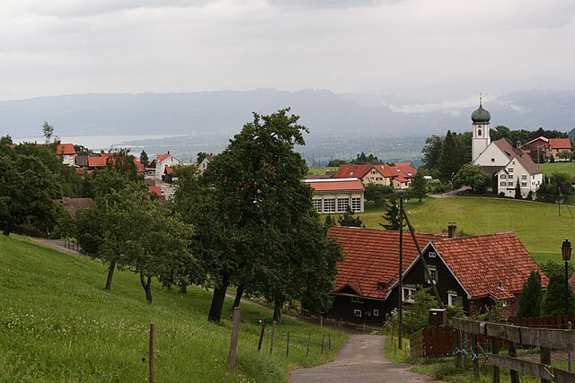
Speicher
- municipality in Switzerland
Hiking in Speicher
Speicher, located in the Appenzell Region of Switzerland, is an ideal destination for hiking enthusiasts. The area offers a picturesque blend of meadows, forests, and stunning mountain views. Here are some key highlights of hiking in Speicher:...
- Country:
- Postal Code: 9042
- Local Dialing Code: 071
- Licence Plate Code: AR
- Coordinates: 47° 24' 38" N, 9° 26' 36" E
- GPS tracks (wikiloc): [Link]
- AboveSeaLevel: 936 м m
- Area: 8.17 sq km
- Population: 4293
- Web site: [Link]

Stein
- municipality in Switzerland
Hiking in Stein
Hiking in Stein, located in the Appenzell region of Switzerland, offers a fantastic experience surrounded by stunning landscapes, rolling hills, and mountainous terrain. This area is known for its picturesque scenery, vibrant green meadows, and traditional Swiss chalets, making it a perfect destination for outdoor enthusiasts....
- Country:
- Postal Code: 9063
- Local Dialing Code: 071
- Licence Plate Code: AR
- Coordinates: 47° 22' 36" N, 9° 20' 30" E
- GPS tracks (wikiloc): [Link]
- AboveSeaLevel: 800 м m
- Area: 9.37 sq km
- Population: 1423
- Web site: [Link]


Teufen
- municipality in Switzerland
Hiking in Teufen
Teufen, located in Appenzell Ausserrhoden, Switzerland, offers a stunning setting for hiking enthusiasts. The region is characterized by beautiful meadows, rolling hills, and breathtaking views of the Appenzell Alps. Here are some highlights of hiking in this area:...
- Country:
- Postal Code: 9053
- Local Dialing Code: 071
- Licence Plate Code: AR
- Coordinates: 47° 23' 37" N, 9° 23' 19" E
- GPS tracks (wikiloc): [Link]
- AboveSeaLevel: 875 м m
- Area: 15.3 sq km
- Population: 6267
- Web site: [Link]

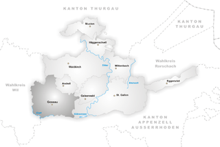
Gossau
- municipality in the canton of St. Gallen, Switzerland
Hiking in Gossau
Gossau, located in the canton of St. Gallen in Switzerland, offers fantastic hiking opportunities with stunning views and diverse terrains, making it a great destination for both casual hikers and more experienced outdoor enthusiasts....
- Country:
- Postal Code: 9200
- Local Dialing Code: 071
- Licence Plate Code: SG
- Coordinates: 47° 24' 59" N, 9° 15' 0" E
- GPS tracks (wikiloc): [Link]
- AboveSeaLevel: 638 м m
- Area: 27.51 sq km
- Population: 18171
- Web site: [Link]