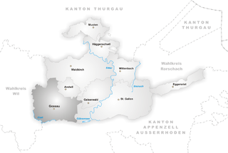
St. Gallen Constituency (Wahlkreis St. Gallen)

- district in Switzerland
 Hiking in St. Gallen Constituency
St. Gallen (Wahlkreis), located in the eastern part of Switzerland, offers a variety of stunning hiking trails suitable for all levels, from casual walkers to experienced hikers. The region is characterized by picturesque landscapes including rolling hills, dense forests, and views of the nearby Alps.
Key Hiking Areas:
-
Appenzellerland: This area features several scenic trails with breathtaking views. The Appenzeller Panorama Trail is particularly popular, offering a moderate hike that showcases the beauty of the region.
-
Säntis Mountain: This iconic peak is the highest in Eastern Switzerland. There are several routes leading to the summit, with options ranging from more accessible paths to challenging scrambles. The viewpoint at the top is truly rewarding, providing panoramic vistas.
-
Walensee: The trails around Lake Walen (Walensee) offer serene hikes along the water's edge, including the popular Linth River Trail. The combination of lake views and mountainous backdrops creates an idyllic setting for hikers.
-
The Toggenburg Region: The Toggenburg offers a network of trails that wind through lush meadows and charming villages. This region is perfect in all seasons, with opportunities for both summer hiking and winter snowshoeing.
Tips for Hiking in St. Gallen:
-
Trail Information: Always check local hiking maps and trail conditions before heading out. The Swiss hiking trail network is well-marked, but it's good to be prepared with the latest info.
-
Weather Considerations: The weather can change rapidly in the mountains. Dress in layers and bring waterproof gear to ensure a comfortable hike.
-
Safety: Make sure to inform someone about your hiking plans, especially if you’re heading to more remote areas. Carry sufficient water and snacks, and be aware of your surroundings.
-
Respect Nature: Stick to marked trails, and help preserve the natural beauty of the area by following the Leave No Trace principles.
With its breathtaking scenery and diverse trails, St. Gallen (Wahlkreis) is a fantastic destination for hiking enthusiasts. Whether you're looking for an easy day hike or an adventurous mountain trek, you'll find plenty to explore!
- Country:

- Capital: St. Gallen
- Licence Plate Code: SG
- Coordinates: 47° 27' 48" N, 9° 23' 26" E


- GPS tracks (wikiloc): [Link]
- AboveSeaLevel: 602 м m
- Area: 157.54 sq km
- Wikipedia en: wiki(en)
- Wikipedia: wiki(de)
- Wikidata storage: Wikidata: Q661143
- Wikipedia Commons Category: [Link]
- Freebase ID: [/m/0641mzg]
- GeoNames ID: Alt: [6458770]
- archINFORM location ID: [42746]
Includes regions:


St. Gallen
- capital of St. Gallen canton in Switzerland
Hiking in St. Gallen
St. Gallen, located in the northeastern part of Switzerland, is an excellent destination for hiking enthusiasts. The region is characterized by stunning landscapes, including rolling hills, lush forests, and panoramic mountain views. Here are some highlights of hiking in and around St. Gallen:...
- Country:
- Postal Code: 9000
- Local Dialing Code: 071
- Licence Plate Code: SG
- Coordinates: 47° 25' 24" N, 9° 22' 38" E
- GPS tracks (wikiloc): [Link]
- AboveSeaLevel: 675 м m
- Area: 39.41 sq km
- Population: 75481
- Web site: [Link]
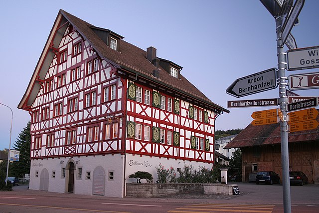

Waldkirch
- municipality in the canton of St. Gallen, Switzerland
Hiking in Waldkirch
Waldkirch is a charming village located in the scenic region of the Emmental in Switzerland, surrounded by picturesque landscapes that are perfect for hiking enthusiasts. Here are some highlights and tips for hiking in and around Waldkirch:...
- Country:
- Postal Code: 9205
- Local Dialing Code: 071
- Licence Plate Code: SG
- Coordinates: 47° 27' 59" N, 9° 16' 59" E
- GPS tracks (wikiloc): [Link]
- AboveSeaLevel: 629 м m
- Area: 31.25 sq km
- Population: 3498
- Web site: [Link]


Wittenbach
- municipality in the canton of St. Gallen, Switzerland
Hiking in Wittenbach
Wittenbach is a beautiful area for hiking, located in the canton of St. Gallen in Switzerland. The region offers a mix of lush landscapes, scenic views, and well-marked trails that can cater to various skill levels. Here are some key points to consider if you're planning a hiking trip in Wittenbach:...
- Country:
- Postal Code: 9300
- Local Dialing Code: 071
- Licence Plate Code: SG
- Coordinates: 47° 28' 0" N, 9° 22' 46" E
- GPS tracks (wikiloc): [Link]
- AboveSeaLevel: 588 м m
- Area: 12.22 sq km
- Population: 9784
- Web site: [Link]


Häggenschwil
- municipality in Switzerland
Hiking in Häggenschwil
Häggenschwil is a picturesque village located near the city of St. Gallen in Switzerland, offering access to beautiful hiking opportunities. The region is characterized by its rolling hills, lush forests, and views of the surrounding landscape, making it a great destination for outdoor enthusiasts....
- Country:
- Postal Code: 9312
- Local Dialing Code: 071
- Licence Plate Code: SG
- Coordinates: 47° 28' 59" N, 9° 21' 0" E
- GPS tracks (wikiloc): [Link]
- AboveSeaLevel: 554 м m
- Area: 9.10 sq km
- Population: 1332
- Web site: [Link]

Gaiserwald
- municipality in Switzerland
Hiking in Gaiserwald
Gaiserwald is a beautiful area in Switzerland, known for its picturesque landscapes and diverse hiking trails. Here are some key points to consider when hiking in Gaiserwald:...
- Country:
- Postal Code: 9030
- Local Dialing Code: 071
- Licence Plate Code: SG
- Coordinates: 47° 25' 49" N, 9° 19' 39" E
- GPS tracks (wikiloc): [Link]
- AboveSeaLevel: 650 м m
- Area: 12.64 sq km
- Population: 8368
- Web site: [Link]
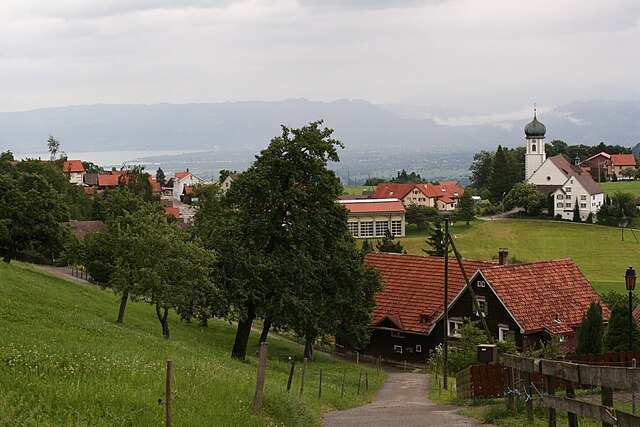

Eggersriet
- municipality in Switzerland
Hiking in Eggersriet
Eggersriet is a charming little town located in the canton of St. Gallen, Switzerland, nestled amidst beautiful landscapes. Hiking in and around Eggersriet allows you to enjoy breathtaking views of the surrounding hills, forests, and rural scenery....
- Country:
- Postal Code: 9034
- Local Dialing Code: 071
- Licence Plate Code: SG
- Coordinates: 47° 26' 59" N, 9° 27' 59" E
- GPS tracks (wikiloc): [Link]
- AboveSeaLevel: 817 м m
- Area: 8.82 sq km
- Population: 2275
- Web site: [Link]


Muolen
- municipality in Switzerland
Hiking in Muolen
Muolen is a charming region known for its scenic landscapes and outdoor activities, making it a fantastic destination for hikers. It offers a variety of trails that cater to different skill levels, from beginners to more experienced hikers. Here are some key aspects of hiking in Muolen:...
- Country:
- Postal Code: 9313
- Local Dialing Code: 071
- Licence Plate Code: SG
- Coordinates: 47° 31' 0" N, 9° 18' 59" E
- GPS tracks (wikiloc): [Link]
- AboveSeaLevel: 490 м m
- Area: 10.30 sq km
- Population: 1200
- Web site: [Link]


Andwil
- municipality in the canton of St. Gallen, Switzerland
Hiking in Andwil
Andwil is a charming municipality located in the canton of St. Gallen, Switzerland. It is situated in a picturesque area characterized by rolling hills, lush green meadows, and stunning views of the surrounding Alps. Hiking in and around Andwil offers a variety of trails suitable for different skill levels, making it a great destination for both beginners and more experienced hikers....
- Country:
- Postal Code: 9204
- Local Dialing Code: 071
- Licence Plate Code: SG
- Coordinates: 47° 26' 26" N, 9° 16' 52" E
- GPS tracks (wikiloc): [Link]
- AboveSeaLevel: 733 м m
- Area: 6.29 sq km
- Population: 1951
- Web site: [Link]

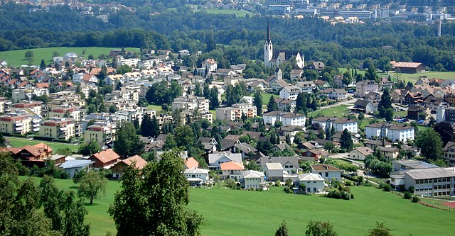
Gossau
- municipality in the canton of St. Gallen, Switzerland
Hiking in Gossau
Gossau, located in the canton of St. Gallen in Switzerland, offers fantastic hiking opportunities with stunning views and diverse terrains, making it a great destination for both casual hikers and more experienced outdoor enthusiasts....
- Country:
- Postal Code: 9200
- Local Dialing Code: 071
- Licence Plate Code: SG
- Coordinates: 47° 24' 59" N, 9° 15' 0" E
- GPS tracks (wikiloc): [Link]
- AboveSeaLevel: 638 м m
- Area: 27.51 sq km
- Population: 18171
- Web site: [Link]